2 Weeks in Benelux Road Trip Itinerary
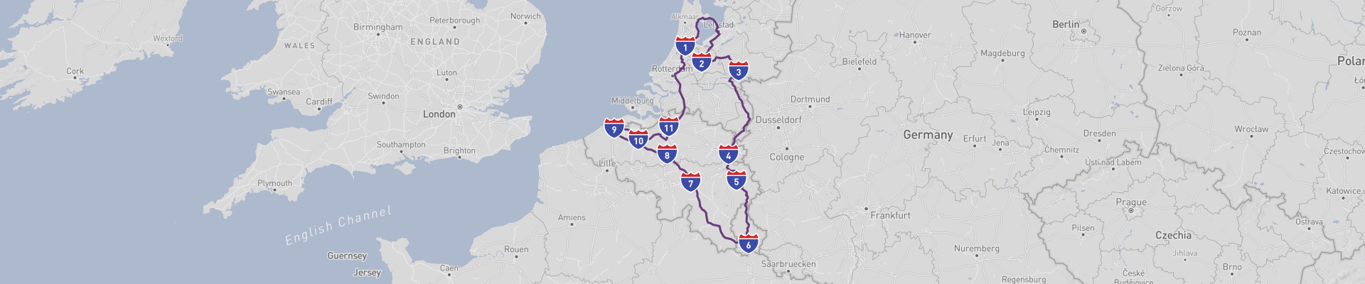
2 Weeks in Benelux Road Trip is a relaxed loop of about 1223km that starts and ends in Amsterdam in the Netherlands, taking you through Utrecht, Maastricht, Luxembourg City, Brussels and Ghent before heading back to Amsterdam. Plan about 14 days for this route so you have enough time to explore cities, make detours into the countryside and not feel rushed on driving days.
The best time of year to drive this route is from late April to early October. Late spring and early summer give you long daylight hours, milder temperatures and a good chance of dry roads, while early autumn is quieter and often still pleasant. July and August are warm but busier and more expensive, especially in major cities.
You start in Amsterdam, a city that mixes canals, culture and nightlife. Even though this is your starting point rather than a stop on the route, it’s worth taking at least a day to walk or bike along the canals, visit the Anne Frank House and check out the Rijksmuseum and Van Gogh Museum. The canal ring (Grachtengordel) itself is part of the UNESCO World Heritage list, so just wandering the historic center already ticks off a major sight.
Leaving Amsterdam, you head to Utrecht. It’s smaller and more laid-back than the capital but has a similar canal charm with its own twist: the lower wharves along the Oudegracht where cafés and terraces sit right by the water. The Dom Tower dominates the skyline; climbing it gives wide views over the old town and beyond. Utrecht’s compact center is perfect for walking, and you’ll find lots of bars, restaurants and boutiques packed into its medieval streets. It’s a good place for a canal-side lunch before continuing south.
Further down you reach Maastricht, almost on the border with Belgium and Germany. This is one of the oldest cities in the Netherlands and feels different from the north: more hilly surroundings, a mix of French and Belgian influences and a strong café culture. The cobbled streets around Vrijthof and the Basilica of Saint Servatius are worth a slow stroll. If you have time, the underground caves and tunnels of the Sint Pietersberg are a fun contrast to the elegant city center. Maastricht is also a comfortable base for exploring the rolling Limburg countryside with its vineyards and small villages.
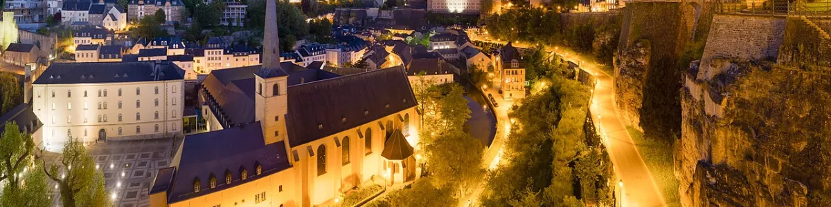
Crossing into Luxembourg takes you to Luxembourg City, dramatically set on cliffs above deep gorges. The fortified old quarters and fortifications are a UNESCO World Heritage Site, and the Chemin de la Corniche offers some of the best viewpoints over the valleys and bridges. Don’t miss the Bock Casemates, a network of tunnels cut into the rock that once formed part of the city’s defenses. The compact old town is easy to cover on foot; beyond that, short drives lead into quiet forests and valleys, making Luxembourg a pleasant mix of city and nature on this road trip.
From Luxembourg City you drive to Brussels, the de facto capital of the EU and a mix of historic and modern. The Grand Place (Grote Markt) is the big highlight and a UNESCO World Heritage Site, surrounded by ornate guildhalls and the Town Hall. It’s especially impressive in the evening when the buildings are lit up. Other must-see spots include the Atomium, built for the 1958 World Expo, and the Royal Museums of Fine Arts. If you like comics or Art Nouveau, Brussels is full of themed walks and buildings. Between museums, grab Belgian fries, waffles and some local beer to get a taste of the city’s food culture.
Next stop is Ghent, often less crowded than nearby Bruges but just as beautiful, with a more local, studenty feel. The medieval center around the Graslei and Korenlei quays is perfect for a canal boat tour or just sitting by the water. The castle of the Counts (Gravensteen) sits right in the middle of town and is easy to visit. Inside Saint Bavo’s Cathedral you’ll find the famous altarpiece “The Adoration of the Mystic Lamb.” Ghent’s mix of gothic towers, canals and street art makes it a great place to spend a day or two before turning back toward the Netherlands.
The final leg brings you back to Amsterdam, passing through flat Dutch landscapes and plenty of potential side trips if you have time left: small historic towns, windmill areas like Kinderdijk (another UNESCO site if you choose to detour) or coastal stretches along the North Sea. Ending the loop in Amsterdam keeps logistics simple and allows you to return the car and fly or train out easily.
Overall road conditions in the Benelux countries are very good: highways and main roads are well maintained, signage is clear and fuel stations and service areas are frequent. Still, there are a few things to be aware of. Traffic can be heavy around big cities like Amsterdam, Brussels and Luxembourg City, especially during rush hours, and parking in historic centers is often limited and expensive, so it’s smart to use park-and-ride facilities or choose accommodation with parking. Speed cameras are common, and each country has its own speed limits and rules, so check them before you go. In bad weather (heavy rain, fog or winter conditions outside the recommended season) visibility and grip can drop quickly, especially on smaller rural roads. As always, keep an eye out for cyclists in Dutch and Belgian cities, watch for tram lines and one-way systems, and avoid driving when you’re tired so you can fully enjoy the 2 Weeks in Benelux Road Trip.
 14
number of days
14
number of days
 1,223 km
route length
1,223 km
route length
 high
budget
high
budget
 family
good for
family
good for
 on the right
traffic direction
on the right
traffic direction
 moderate
accident level
moderate
accident level
START
Amsterdam
Distance 1,223 km
Driving time 17.1 h
Pace: fast
366.8 kWh
Airports
AMS
,
LEY
[detailsContainer]
Amsterdam is an ideal kick-off point for your 2 Weeks in Benelux Road Trip, mixing big-city buzz with compact, easy-to-navigate streets and great road connections in all directions.
The historic center is small enough to explore on foot before you pick up your car. Wander the canal belt (Grachtengordel), a UNESCO site lined with narrow gabled houses, cafes, and houseboats. Don’t miss the Jordaan district for its cozy streets, indie shops, and bar-filled corners that come alive at night.
For classic culture, the Museumplein area is your go-to. The Rijksmuseum packs in Dutch Golden Age masters like Rembrandt and Vermeer, while the Van Gogh Museum has the world’s largest Van Gogh collection. Nearby, the Stedelijk Museum focuses on modern and contemporary art. If you’re into history, the Anne Frank House is powerful and sobering—book tickets well in advance.
Need some chill time before long driving days? Head to Vondelpark for a walk or picnic, or jump on a ferry behind Central Station to explore Amsterdam-Noord with its street art, creative spaces, and the A’DAM Lookout panorama platform.
If you’re flying in, the closest international airport is Amsterdam Airport Schiphol (AMS), located just outside the city. From Schiphol, it’s an easy train ride (around 15–20 minutes) to Amsterdam Centraal if you want to explore the city first, or you can head straight to your rental car and hit the road.
Car rentals are widely available at Schiphol. Major international and local companies (like Hertz, Avis, Sixt, Europcar, Enterprise, and more) operate directly from the airport’s car rental center, which is linked to the terminal. Booking ahead usually gets you better prices and guarantees the car category you want for your Benelux road adventure.
1
Amsterdam
- Utrecht
Distance 175 km
Driving time 2.5 h
Pace: fast
52.6 kWh
↓
View map
↓
Itinerary
[detailsContainer]
Leaving Amsterdam and rolling out towards Utrecht, you’ve got about 175 km ahead of you and fewer than 3 hours behind the wheel, so there’s plenty of time to enjoy the ride without rushing.
Before you hit the road, soak up Amsterdam’s mix of history and laid‑back vibes: wander its canal-side streets, check out the old merchant houses, and enjoy the lively waterfront corners that make leaving a little bit hard. Once you’re driving, keep an eye out for historical sites and stretches of scenic road; some UNESCO Heritage sites are along the route, and they’re worth slowing down for, even if just for a quick photo stop or a short walk.
As you get closer to Utrecht, the scenery tightens up and in sections the road will be narrow, so take it easy and enjoy the more intimate feel of the countryside. Utrecht itself welcomes you with atmospheric streets, peaceful canals, and a beautifully preserved old center that’s perfect for an evening stroll after a day on the road.
For more details on attractions, accommodation options, recommended restaurants, and campsites along the route, check the "Itinerary" of this stage.
 Utrecht - Netherlands - Europe - Road Trip - Wikimedia Commons
Utrecht - Netherlands - Europe - Road Trip - Wikimedia Commons
Utrecht - Netherlands - Europe - Road Trip - pxhere.com
❯
❮
2
Utrecht
- Arnhem
Distance 80 km
Driving time 1.3 h
Pace: fast
23.9 kWh
↓
View map
↓
Itinerary
[detailsContainer]
Leaving Utrecht, you roll out of a lively canal city that’s perfect for a quick pre-drive wander. Before you hit the road, walk or bike around the canals near Oudegracht, check out the views from the Dom Tower, and enjoy the relaxed café vibe along the water. Once you’re driving, you’ll cover about 80 km in under 2 hours, so there’s no rush—take it easy and enjoy the changing views as the city gives way to open Dutch countryside.
As you get closer to Arnhem, keep an eye out for greener, more rolling landscapes and stretches of road that feel made for a slow, scenic cruise. Arnhem itself rewards you with a mix of culture and history: dive into the story of World War II at the John Frost Bridge, or stretch your legs in Park Sonsbeek, where wooded paths and ponds are ideal after some time behind the wheel. The city center adds a nice finish to the drive, with streets that invite a relaxed stroll and a drink on a terrace before you move on.
More info on attractions, accommodation options, recommended restaurants, and campsites along this route is available in the Itinerary of this stage.
Arnhem - Netherlands - Europe - Road Trip - Wikimedia Commons
Arnhem - Netherlands - Europe - Road Trip - Wikimedia Commons
Arnhem - Netherlands - Europe - Road Trip - Wikimedia Commons
❯
❮
3
Arnhem
- Maastricht
Distance 166 km
Driving time 1.9 h
Pace: fast
49.8 kWh
↓
View map
↓
Itinerary
[detailsContainer]
Rolling out of Arnhem, you’ll ease into a 166 km drive that takes fewer than 2 hours, but you’ll want to slow down and make it count.
Start by wandering Arnhem’s historic heart, where war-scarred streets meet leafy parks and old architecture. As you steer south, keep an eye out for gentle hills and river views that break up the flat Dutch stereotype; this stretch rewards anyone who enjoys watching the landscape quietly shift from open countryside to more rugged, story-filled terrain.
Gliding into Maastricht, the vibe changes again. Park up and dive into its maze of old streets, where grand squares and centuries-old buildings sit right next to lively cafés. It’s a place made for unhurried exploring: cobbles under your feet, church towers above, and a relaxed buzz all around. When you drive in or out, stay alert for scenic bends and views over the river that make the last kilometers especially satisfying behind the wheel.
More information regarding attractions, accommodation options, recommended restaurants, and campsites along the route is available in the bItineraryb of this stage.
Maastricht - Netherlands - Europe - Road Trip - commons.wikimedia.org
Maastricht - Netherlands - Europe - Road Trip - pixabay.com
Maastricht - Netherlands - Europe - Road Trip - pixabay.com
❯
❮
4
Maastricht
- Spa
Distance 61 km
Driving time 0.8 h
Pace: fast
18.2 kWh
↓
View map
↓
Itinerary
[detailsContainer]
Starting in Maastricht, you roll out from a city where history sits right on the river. Before you hit the road, wander around the Vrijthof and check out the Basilica of Saint Servatius and Saint John’s Church – the mix of medieval stone and bright red tower is a great send-off for a driving day. The route to Spa is only about 61 km and takes fewer than 1 hours, but it’s worth taking it slow: you’ll be crossing the state border and the landscape quickly turns more hilly and wooded, with some really scenic road sections that beg for a quick photo stop.
As you approach Spa, the atmosphere shifts to that classic spa-town charm. Park up and stroll around the historic thermal baths area, then head toward the surroundings of the Spa-Francorchamps zone, where the winding roads and forested hills show off some of the most picturesque landscapes on this stage. It’s a fun mix of relaxed town vibes and driver-friendly curves that make the approach as enjoyable as the destination itself.
More info on attractions, accommodation options, recommended restaurants, and campsites along the route is available in the "Itinerary" of this stage.
Spa - Netherlands - Europe - Road Trip - commons.wikimedia.org
❯
❮
5
Spa
- Luxembourg City
Distance 142 km
Driving time 2.2 h
Pace: fast
42.6 kWh
↓
View map
↓
Itinerary
[detailsContainer]
Starting in Spa, Belgium, you roll out from a town famous for its thermal heritage and elegant Belle Époque charm, where historic buildings and leafy streets already set a relaxed mood for the drive.
Once you’re on the road, keep an eye out for historical sites and picturesque landscapes as the route unfolds over 142 km, with a driving time of fewer than 3 hours. Some stretches follow a properly scenic road, with forested hills and open views, and in some sections the road is very winding, so it’s worth taking it easy and enjoying the curves. Along the way, you will cross a state border before reaching Luxembourg City, and there are some UNESCO Heritage sites along the route that underline how rich this corridor is in culture and history.
Rolling into Luxembourg City, you’re rewarded with dramatic fortifications, impressive bridges, and layers of old and new architecture stacked above deep gorges. The historic quarters here are packed with atmosphere, and wandering on foot reveals just how strategically and beautifully this city was built.
More detailed information about attractions, accommodation options, recommended restaurants, and campsites along the route is available in the Itinerary of this stage.
Luxembourg City - Netherlands - Europe - Road Trip
Luxembourg City - Netherlands - Europe - Road Trip - commons.wikimedia.org
❯
❮
6
Luxembourg City
- Namur
Distance 154 km
Driving time 1.6 h
Pace: fast
46.2 kWh
↓
View map
↓
Itinerary
[detailsContainer]
Leaving Luxembourg City and heading to Namur, you’ll cover about 154 km in less than 2 hours, but it’s worth taking it slow. Roll out of Luxembourg City after a stroll around the Old Quarters and Fortifications, whose UNESCO‑listed walls, gates, and viewpoints set the tone for a trip full of history and dramatic scenery. As you drive, keep an eye out for the changing landscape: gentle hills, forested stretches, and rivers that make the road feel pleasantly scenic rather than just a connection between two cities. Along the route you’ll cross a state border, and you’ll have some UNESCO Heritage sites not far from your path, so it’s a good idea to plan short detours if you’re into culture and architecture.
Namur welcomes you with its relaxed vibe and the impressive Citadel of Namur towering over the confluence of the Meuse and Sambre. Drive up to the fortress for sweeping views, atmospheric ramparts, and winding roads that are especially fun for road‑trippers. It’s a fitting finish to a stage where historical sites and picturesque landscapes go hand in hand.
More information regarding attractions, accommodation options, recommended restaurants, and campsites along the route is available in the "Itinerary" of this stage.
Namur - Netherlands - Europe - Road Trip - commons.wikimedia.org
❯
❮
7
Namur
- Brussels
Distance 64 km
Driving time 0.9 h
Pace: fast
19.3 kWh
↓
View map
↓
Itinerary
[detailsContainer]
Leaving Namur, you roll out from the shadow of the mighty Citadelle de Namur, perched above the Meuse. It’s worth a last quick wander before you hit the road: the fortress walls, old barracks, and sweeping river views really set the tone for a drive rich in history.
The 64 km to Brussels fly by in under 1 hour, but don’t rush it. Along the way, keep an eye out for historical sites; some UNESCO Heritage sites are along the route, and the landscape quietly shifts from riverside hills to the edges of the capital.
As you reach Brussels, dive straight into the heart of the city at the Grand-Place, surrounded by ornate guild houses and the impressive Town Hall. From there, it’s an easy spin over to the Atomium, where the futuristic structure and panoramic views give you a completely different angle on the city. Wrap it up at the Manneken Pis, small but iconic, tucked in the streets just off the Grand-Place.
More info about attractions, accommodation options, recommended restaurants, and campsites along the route is available in the b"Itinerary"/b of this stage.
Brussels - Netherlands - Europe - Road Trip - pixabay.com
Brussels - Netherlands - Europe - Road Trip - commons.wikimedia.org
❯
❮
8
Brussels
- Bruges
Distance 95 km
Driving time 1.2 h
Pace: fast
28.6 kWh
↓
View map
↓
Itinerary
[detailsContainer]
Rolling out of Brussels, you dive straight into grand history. Before you leave, take time for the majestic Grand Place and the sturdy Town Hall, then swing by the Atomium for that retro‑futuristic vibe and a cool city panorama. As you hit the road toward Bruges, keep an eye out for historical sites along the way; some UNESCO Heritage sites are along the route, so this is not just a transfer, it is a mini‑time‑travel session.
The run to Bruges is about 95 km and, with smooth traffic, easily done in fewer than 2 hours, giving you plenty of room for photo stops and coffee breaks. Rolling into Bruges, the scenery shifts into pure storybook mode: wander through the Markt, climb the Belfry for rooftop views, and let yourself get lost between the Burg and the canals. The whole historic center rewards slow strolling after a day behind the wheel, especially when the light hits the old facades in the late afternoon.
For more details on attractions, accommodation options, recommended restaurants, and campsites along the route, check the "Itinerary" of this stage.
Bruges - Netherlands - Europe - Road Trip - www.publicdomainpictures.net
Bruges - Netherlands - Europe - Road Trip - pixabay.com
❯
❮
9
Bruges
- Ghent
Distance 50 km
Driving time 1.3 h
Pace: slow
11.6 kWh
↓
View map
↓
Itinerary
[detailsContainer]
Starting in Bruges, you roll out from a maze of cobbled streets, canals, and step-gabled houses that feel straight out of a storybook. Before hitting the road, wander around the Markt and the Belfry, then drift toward the Beguinage and the historic city center. These spots are part of some UNESCO Heritage sites that lie along your route and give Bruges its unmistakable medieval character.
Once you leave town, the 50 km drive to Ghent takes fewer than 2 hours, so you can cruise at an easy pace. Keep an eye out for scenic stretches with tree-lined roads, waterways, and small villages that echo the same historic charm as the cities they link. This is the kind of drive where you might want to pull over just to soak in the views.
Rolling into Ghent, the skyline of towers and spires pulls you in. Park up and explore the medieval heart of the city, especially Gravensteen Castle and the area around the old Graslei and Korenlei quays. The blend of history, canals, and vibrant city life makes Ghent a perfect contrast to Bruges.
More info on attractions, accommodation options, recommended restaurants, and campsites along the route is available in the "Itinerary" of this stage.
Ghent - Netherlands - Europe - Road Trip - pixabay.com
Ghent - Netherlands - Europe - Road Trip - www.wallpaperflare.com
❯
❮
10
Ghent
- Antwerp
Distance 74 km
Driving time 1.2 h
Pace: fast
22.2 kWh
↓
View map
↓
Itinerary
[detailsContainer]
Rolling out of Ghent, you’ll want to give yourself fewer than 2 hours for the 74 km drive so you have time to wander. Before hitting the road, walk or bike around the historic heart of Ghent, especially the area around the old guild houses and waterways, where every corner feels like a backdrop for medieval traders and craftsmen.
When you drive towards Antwerp, keep an eye out whenever you pass older town centers or church towers on the horizon; many of these silhouettes hide stories from centuries of trade, war, and faith, and they’re a good reminder that this whole stretch has been busy since long before cars existed.
Rolling into Antwerp, head straight for its historic core. The old streets and squares lined with step‑gabled houses, the cathedral tower rising over the rooftops, and the bustling market area all tell you you’ve arrived in a city built on seafaring, art, and commerce. Park up, stretch your legs, and get lost in the lanes where merchants and painters once made their fortunes.
More details on attractions, accommodation options, recommended restaurants, and campsites along this stage are available in the Itinerary of this route.
Antwerp - Netherlands - Europe - Road Trip - commons.wikimedia.org
Antwerp - Netherlands - Europe - Road Trip - commons.wikimedia.org
Antwerp - Netherlands - Europe - Road Trip - commons.wikimedia.org
❯
❮
11
Antwerp
- Amsterdam
Distance 161 km
Driving time 2.2 h
Pace: fast
48.4 kWh
↓
View map
↓
Itinerary
[detailsContainer]
Leaving Antwerp and heading for Amsterdam, you’ve got about 161 km of relaxed driving ahead of you, with fewer than 3 hours behind the wheel, so there’s plenty of time to enjoy what’s on the way.
Before rolling out of Antwerp, wander around the historic center and the impressive Cathedral of Our Lady, a UNESCO World Heritage site that anchors the city’s skyline. The old streets and grand squares here are perfect for a quick stroll and a coffee before hitting the road.
As you drive north, you’ll cross the state border into the Netherlands, passing through flat, open landscapes where waterways, dikes, and wide skies make the scenery feel almost painterly. Keep an eye out for historical farmsteads and traditional villages tucked into this countryside; they bring real character to the route and hint at the region’s long trading and maritime history.
Rolling into Amsterdam, shift into city-cruise mode and explore the Canal Ring, another UNESCO World Heritage site. The canals, historic houses, and old bridges are best enjoyed slowly, whether you’re walking, cycling, or taking a boat tour.
More info on attractions, accommodation, recommended restaurants, and campsites along this stage is available in the "Itinerary" of this route.
Amsterdam - Netherlands - Europe - Road Trip - pixabay.com
❯
❮
Amsterdam
[detailsContainer]
Amsterdam is the perfect finale for your 2 Weeks in Benelux Road Trip, blending big-city buzz with easy-going canalside vibes. If you’re flying in or out, the closest international airport is Amsterdam Airport Schiphol (AMS), just southwest of the city and super easy to reach by car and train.
For roadtrippers, driving into Amsterdam means dealing with narrow streets, bikes everywhere, and pricey parking, so it’s usually smarter to park at a P+R on the edge of town and hop on tram or metro. Once you’re in, the city is super walkable and bike-friendly, and you won’t really need your car until you roll out again.
Must-see spots start with the historic Canal Ring, where just wandering along the water is a highlight on its own. Swing by Dam Square to see the Royal Palace, then head to the Anne Frank House (book tickets way ahead). Museum fans should hit the Rijksmuseum for Dutch Masters and the Van Gogh Museum for the world’s biggest Van Gogh collection. Nearby, the green lawns of Museumplein are a chill place to hang out between sights.
If you’re into more offbeat areas, check out De Pijp for bars and the Albert Cuyp Market, or the Jordaan district for narrow lanes, cute cafés, and indie shops. At night, the Red Light District is worth a careful walk-through just to understand this side of the city, but keep it respectful and skip the photos.
As a roadtrip end point, Amsterdam makes it easy to wind down: park the car, wander the canals, grab a canal cruise, and enjoy one last Dutch beer or stroopwafel before heading home from AMS.
Amsterdam - Netherlands - Europe - Road Trip - pixabay.com
❯
❮
2 Weeks in Benelux Road Trip at a glance
-
Start:
Amsterdam
-
End:
Amsterdam
-
Distance:
1,223 km
-
Stay:
14 days
-
Getting there:
Amsterdam Airport Schiphol (AMS),
Lelystad Airport (LEY)
-
When to drive:
April, May, June, July, August, September, October
-
More info:
More info you can find in the "Itinerary" section at each stage.

 -
-