Military Memorial Road Trip Itinerary
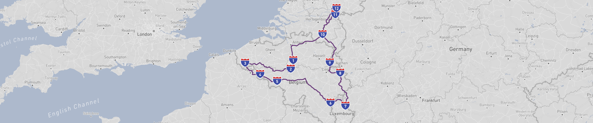
The Military Memorial Road Trip is a circular journey of about 1046km that starts and ends in Brussels, Belgium, and is best enjoyed over about 10 days. It’s made for travelers who like history, World War battlefields, and quiet drives through Belgium and the southern Netherlands, with plenty of time to stop, walk around, and reflect.
Leaving Brussels, your first major stop is Waterloo, just south of the capital. This is where Napoleon was finally defeated in 1815, and the whole area is basically an open‑air history book. The main highlight is the Lion’s Mound, a huge artificial hill topped with a lion statue; climb the stairs for a panoramic view of the battlefield and the surrounding countryside. Nearby you’ll find the Memorial 1815 visitor center, with immersive exhibits and films that explain the battle in a clear, engaging way. You can also visit the Hougoumont Farm and other preserved farmsteads that played a key role in the fighting. The roads around Waterloo are easy to drive, with plenty of signposts and parking spots near the main sites, so it’s simple to hop in and out for short visits and walks.
From there, you continue west and slightly south towards Tournai, one of Belgium’s oldest cities. Tournai combines military history with medieval charm. Its absolute must‑see is the Notre-Dame Cathedral, which is a UNESCO World Heritage Site thanks to its striking mix of Romanesque and Gothic architecture and its five impressive towers. Inside, you’ll find beautiful stained glass and religious art that survived centuries of conflict. The Grand-Place is lined with historic buildings and makes a good spot for a break, and you can also explore the Belfry of Tournai, which is part of the UNESCO-listed Belfries of Belgium and France. While not strictly “military memorials,” both the cathedral and belfry tell the story of a city that has seen invasions, sieges, and shifting borders for centuries. The drive into and out of Tournai is straightforward, but streets in the center can be narrow and busy; it’s usually easier to park a bit outside the core and walk in.
After Tournai, the route bends eastward across southern Belgium towards Bastogne, deep in the Ardennes. This is one of the most moving stops of the trip, especially for anyone interested in World War II. Bastogne is famous for the Battle of the Bulge (1944–45), when Allied troops held out under siege in harsh winter conditions. The Bastogne War Museum is a must‑see: it offers detailed, modern exhibitions about the battle, with personal stories, artifacts, and multimedia displays that make the history very tangible. Just next door is the Mardasson Memorial, a large star‑shaped monument honoring American soldiers who fell during the battle; you can climb up for a wide view over the countryside that once formed the front lines. Around town, there are various smaller monuments, marked foxholes, and memorial plaques scattered in nearby forests and villages. Roads in the Ardennes are generally good but can be winding and hilly; in bad weather (especially rain or fog), visibility can drop, so it pays to drive calmly and allow extra time between villages.
From Bastogne you head northeast towards Eupen, close to the German border. Eupen itself is quieter and less touristy, but it has a unique character as the heart of Belgium’s small German‑speaking community. The town has a compact historic center with baroque churches, old townhouses, and traces of Prussian and Belgian influence. While Eupen doesn’t have big headline memorials, it’s close to areas that saw heavy fighting in both World Wars, and you’ll notice war cemeteries and small monuments in the surrounding hills and villages. Eupen is also one of the gateways to the High Fens (Hautes Fagnes), a nature reserve that was strategically important and difficult terrain for armies but is now a peaceful landscape of moorland and forest, ideal for a walk to break up your driving. Road quality is generally good, but weather can change quickly in this high plateau region; in cooler months, fog and slippery surfaces are common, and in winter, snow and ice are real possibilities.
Crossing into the Netherlands, the trip continues to Eindhoven, a city that mixes industrial heritage with World War II history. Eindhoven was heavily bombed and liberated in 1944 during Operation Market Garden, and you’ll find several memorials and plaques dedicated to the airborne troops and local resistance. The Liberation Route Europe project has audio spots and signposted sites in and around the city that explain key events. Eindhoven is also home to the Philips company’s historical district, where you can see how the city grew around industry, which in turn made it a strategic target in wartime. While not UNESCO-listed, it’s an interesting window into the 20th century and the rebuilding after destruction. Eindhoven is easy to navigate by car, with broad roads and modern infrastructure, but like any larger city it can get busy at rush hour; a bit of planning around peak traffic times makes your visit smoother.
From Eindhoven, you loop back towards Brussels, passing through calm countryside and smaller Belgian towns that also carry traces of wartime history—small cemeteries, village memorials, and plaques on churches and town halls. The final stretch gives you time to digest everything you’ve seen: from Napoleonic battlefields and medieval strongholds to the scars of two World Wars and the stories of civilians and soldiers who lived through them. Back in Brussels, you can round off the trip by visiting sites like the Royal Museum of the Armed Forces and Military History in the Cinquantenaire Park, which ties together many of the themes and periods you’ve encountered on the road.
The best time of year to drive this route is from late spring to early autumn, roughly May to September. During these months, daylight lasts longer, most museums and memorials keep extended opening hours, and you avoid the harsh winter conditions that can affect the Ardennes and High Fens. Summer is the busiest, but still very manageable compared to major tourist hotspots; early autumn can be especially atmospheric around Bastogne and Eupen, with colorful forests and cooler but comfortable temperatures.
Road conditions along the Military Memorial Road Trip are generally good, with well‑maintained highways and regional roads in both Belgium and the Netherlands. Still, there are a few things to keep in mind: in and around big cities, traffic jams are common at peak times; in older town centers, streets can be narrow, one‑way, and sometimes confusingly signed; and in rural or hilly regions like the Ardennes and High Fens, you’ll face tighter curves, occasional wildlife on the road, and more sudden changes in weather. Rain is frequent, which can make surfaces slippery, and in colder seasons fog and ice are real risks. As always, respect speed limits, watch for cyclists (especially in the Netherlands, where bikes have strong priority), and plan fuel and rest stops in advance so you’re not rushing between sites. With a bit of care, the route is safe, relaxed, and perfectly suited to a thoughtful 10‑day journey through Europe’s military past.
 10
number of days
10
number of days
 1,046 km
route length
1,046 km
route length
 high
budget
high
budget
 family
good for
family
good for
 on the right
traffic direction
on the right
traffic direction
 low
accident level
low
accident level
START
Brussels
Distance 1,046 km
Driving time 14.7 h
Pace: fast
313.9 kWh
Airports
BRU
,
CRL
[detailsContainer]
Brussels, the capital of Belgium and the EU’s political heart, makes a great starting point for the “Military Memorial Road Trip”. It’s compact, easy to navigate, and packed with history, food, and nightlife.
The city’s symbol is the Grand Place, a stunning square surrounded by ornate guildhalls and the Town Hall. Swing by both day and night; the lighting after dark is incredible. Just a short walk away is Manneken Pis, tiny but iconic, usually dressed in one of his many costumes.
For panoramic views, head to Mont des Arts, where you also get a cluster of museums. The Royal Museum of the Armed Forces and Military History in Cinquantenaire Park is especially relevant for roadtrippers interested in military heritage. The Atomium, a futuristic 1950s structure, is a bit outside the center but worth the drive for its views and unusual architecture.
Food-wise, Brussels is perfect for refueling: Belgian fries in paper cones, waffles on every corner, and a massive choice of beers in bars around the city center.
If you’re flying in, the closest international airport is Brussels Airport (IATA: BRU), located in Zaventem, roughly 20–30 minutes from the city center by car depending on traffic.
Car rental at Brussels Airport (BRU)
You’ll find several major car rental companies in the arrivals area and nearby parking garages, including the usual international brands and some local ones. It’s easy to pick up your vehicle right after landing and head straight onto the ring road around Brussels, giving you quick access both into the city and out towards the key sites on your Military Memorial Road Trip.
1
Brussels
- Waterloo
Distance 25 km
Driving time 0.4 h
Pace: fast
7.4 kWh
↓
View map
↓
Itinerary
[detailsContainer]
Leaving Brussels and heading to Waterloo, you’ve got an easy 25 km drive of under an hour ahead of you, but don’t rush it. Start by wandering Brussels’ historic heart: admire the ornate facades of the Grand-Place and soak up the atmosphere in this UNESCO-listed square before you hit the road. When you drive out of the city, keep an eye out for historical sites along the way; some UNESCO Heritage sites are along the route, adding extra depth to this short hop.
In Waterloo, the mood shifts from urban buzz to battlefield history. Park up and climb the Lion’s Mound for a sweeping view over the fields where the Battle of Waterloo took place. The visitor center and panorama help you picture the events that changed European history, making it a powerful stop for anyone who likes to mix driving with storytelling landscapes.
This stage may be short in distance, but it’s packed with places where history is literally built into the streets and fields. More information regarding attractions, accommodation options, recommended restaurants, and campsites along the route is available in the "Itinerary" of this stage.
 Waterloo - Belgium - Europe - Road Trip - commons.wikimedia.org
Waterloo - Belgium - Europe - Road Trip - www.needpix.com
❯
❮
2
Waterloo
- Ypres
Distance 142 km
Driving time 2.2 h
Pace: fast
42.6 kWh
↓
View map
↓
Itinerary
[detailsContainer]
Leaving Waterloo and its famous Lion’s Mound behind, you’ll set off on a relaxed 142 km cruise to Ypres, with fewer than 3 hours behind the wheel. Take a last walk up to the Lion’s Mound before you go; the panoramic view over the Waterloo Battlefield really sets the mood for a day packed with history and big landscapes.
On the road, keep an eye out for historical sites tucked into the countryside and stretches where the scenery opens up into classic Belgian fields and small villages. In some sections the road is very winding, so slow down, enjoy the drive, and give yourself time to pull over for quick photo stops whenever the view demands it.
Rolling into Ypres, the vibe shifts to quiet reflection. Park up and wander to the Menin Gate, where the daily Last Post ceremony is a powerful reminder of the town’s past. Then circle the Ypres Cloth Hall, whose impressive façade dominates the square and makes a perfect backdrop for an evening stroll before dinner.
More information regarding attractions, accommodation options, recommended restaurants, and campsites along the route is available in the Itinerary of this stage.
Ypres - Belgium - Europe - Road Trip - www.flickr.com
❯
❮
3
Ypres
- Tournai
Distance 60 km
Driving time 1.1 h
Pace: modest
15.7 kWh
↓
View map
↓
Itinerary
[detailsContainer]
Starting in Ypres, you’ll roll out from a town where history is present at every corner. Before you hit the road, wander around the impressive Ypres Cloth Hall and its surroundings, where the medieval atmosphere mixes with stories from the First World War. When you set off towards Tournai, keep an eye out along the way: some UNESCO Heritage sites are along the route, so it’s worth planning a couple of short stops and watching the signs carefully as you drive. The distance is about 60 km, with a driving time of fewer than 1 hours, so there’s plenty of room for relaxed visits without rushing.
Tournai is a perfect reward at the end of the stage. Head straight for the Tournai Cathedral, an absolute must-see with its striking towers and rich interior. Nearby, the Tournai Belfry offers a great view if you feel like climbing a bit after the drive. Both places are packed with history and are ideal stops for anyone touring by car and looking to soak up local culture between stretches of open road.
More information regarding attractions, accommodation options, recommended restaurants, and campsites along the route is available in the Itinerary of this stage.
Tournai - Belgium - Europe - Road Trip - www.needpix.com
Tournai - Belgium - Europe - Road Trip - sco.m.wikipedia.org
❯
❮
4
Tournai
- Mons
Distance 49 km
Driving time 0.6 h
Pace: fast
14.7 kWh
↓
View map
↓
Itinerary
[detailsContainer]
Rolling out of Tournai, you’ve got about 49 km and under an hour’s drive ahead, so don’t rush it. Before you leave, wander around the Grand-Place and the narrow streets nearby, then head straight to the stunning Notre-Dame de Tournai Cathedral. Its massive towers and peaceful interior are worth a slow look, and some UNESCO Heritage sites are along the route, so you’re in seriously special territory here.
Once you’re on the road to Mons, keep an eye out for scenic stretches and old villages; it’s the kind of drive where you’ll want to ease off the gas and actually look around. Rolling into Mons, park up near the Grand-Place and explore on foot. The square is full of character, but the real highlight is the Belfry of Mons towering above the town. Climb up or at least get close enough to take in the view and the centuries of history baked into its walls.
If you want more details on attractions, accommodation options, recommended restaurants, and campsites along the route, check out the Itinerary of this stage.
Mons - Belgium - Europe - Road Trip - www.flickr.com
Mons - Belgium - Europe - Road Trip - commons.wikimedia.org
❯
❮
5
Mons
- Bastogne
Distance 165 km
Driving time 1.7 h
Pace: fast
49.5 kWh
↓
View map
↓
Itinerary
[detailsContainer]
Leaving Mons and its UNESCO-listed belfry behind, you’ll roll out on a relaxed 165 km drive to Bastogne, taking fewer than 2 hours if you go straight—but you’ll want to slow down. As you leave the town center of Mons, keep an eye out for historical sites tucked around the belfry and the old streets; they’re worth a quick wander before you hit the open road.
On the way south, the scenery gets greener and more rolling, and in some sections the road is very winding, so enjoy the curves but stay focused—these bends often come right where the views are best. Approaching Bastogne, the atmosphere shifts: this is a place marked by World War II history. Plan time to visit the Bastogne War Museum and the nearby Mardasson Memorial, both powerful stops that give real context to the landscape you’re driving through.
This stage fits perfectly into a longer adventure, linking city charm in Mons with the moving wartime heritage of Bastogne.
For more details on attractions, accommodation options, recommended restaurants, and campsites along the route, check the "Itinerary" of this stage.
Bastogne - Belgium - Europe - Road Trip - commons.wikimedia.org
❯
❮
6
Bastogne
- Vianden
Distance 55 km
Driving time 1.0 h
Pace: modest
14.2 kWh
↓
View map
↓
Itinerary
[detailsContainer]
Leaving Bastogne and rolling towards Vianden, you’ve got about 55 km of easy driving ahead, usually in fewer than 1 hours, but it’s worth taking it slow.
Before you hit the road, give Bastogne a bit of time. Wander around the town center and soak up its powerful wartime history; the streets and buildings still carry that Battle of the Bulge atmosphere. As you drive out, keep an eye out for historical sites along the way and enjoy the changing scenery that quickly turns from town views into classic countryside.
On the road to Vianden, you’ll cross a state border, and you’ll notice the landscape tightening into valleys and hills. In some sections the road is very winding, so it’s fun to drive but demands some attention, especially when you get closer to Vianden’s steep surroundings and panoramic viewpoints.
Rolling into Vianden, the dramatic hillside and castle skyline make the last stretch feel like a movie scene. Park up and explore the charming streets below the castle, then walk up for those big views over the river and rooftops. It’s the perfect finish to this stage.
More info on attractions, accommodation options, recommended restaurants, and campsites along the route is available in the "Itinerary" of this stage.
Vianden - Belgium - Europe - Road Trip - www.flickr.com
Vianden - Belgium - Europe - Road Trip - www.wallpaperflare.com
❯
❮
7
Vianden
- Eupen
Distance 110 km
Driving time 1.8 h
Pace: fast
33.1 kWh
↓
View map
↓
Itinerary
[detailsContainer]
Rolling out of Vianden, you leave one fairy‑tale town and aim for another, with Eupen waiting about 110 km down the road and fewer than 2 hours away.
Before you go, wander up to Vianden Castle towering above the river, an epic medieval stronghold with sweeping views that really set the tone for the drive. The old streets below are perfect for a quick stroll and a last coffee before hitting the road.
Once you’re driving, keep an eye out for historical sites tucked into the hillsides and take your time on the scenic road. The state border will be crossed on this stage, and in some sections the road is very winding and in sections the road will be narrow, so it pays to drive relaxed and enjoy the picturesque landscapes instead of rushing.
Rolling into Eupen, park up and explore the compact old town on foot. The historic core is full of character, with elegant houses and churches hinting at its past as a borderland hub. It’s a chilled place to end the day, grab a bite, and plan your next drive.
More info about attractions, accommodation options, recommended restaurants, and campsites along the route is available in the Itinerary of this stage.
Eupen - Belgium - Europe - Road Trip
❯
❮
8
Eupen
- Maastricht
Distance 53 km
Driving time 0.7 h
Pace: fast
15.8 kWh
↓
View map
↓
Itinerary
[detailsContainer]
Starting in Eupen, you roll out from a town that feels made for slow wandering before you hit the road. Take a little time to stroll through Eupen’s old center, where the mix of German- and French-speaking culture shows up in the streets, cafés, and historic buildings. It’s a spot where you’ll want to park up, stretch your legs, and soak in the atmosphere before driving on.
From Eupen to Maastricht, you’ll cover about 53 km in fewer than 1 hour, but it’s worth not rushing it. The route includes some very winding sections, so keep your speed in check and enjoy the scenic road. You’ll pass areas with historical sites close to the route, and at one point a state border will be crossed, adding a nice “two countries in one drive” feeling to the day.
Rolling into Maastricht, you arrive in a city that’s perfect for road-trippers: compact, lively, and full of character. Park up and dive into its charming streets, riverside views, and historic architecture. Maastricht’s relaxed vibe makes it ideal for an afternoon walk, a drink on a terrace, or a slow evening exploring the old town.
More info about attractions, accommodation options, recommended restaurants, and campsites along the route is available in the "Itinerary" of this stage.
Maastricht - Belgium - Europe - Road Trip - commons.wikimedia.org
Maastricht - Belgium - Europe - Road Trip - pixabay.com
Maastricht - Belgium - Europe - Road Trip - pixabay.com
❯
❮
9
Maastricht
- Eindhoven
Distance 89 km
Driving time 1.2 h
Pace: fast
26.8 kWh
↓
View map
↓
Itinerary
[detailsContainer]
Rolling out of Maastricht, you kick off this 89 km stretch with fewer than 2 hours of easy driving ahead of you.
Before hitting the road, wander through the cobbled streets around the Vrijthof, check out the Basilica of Saint Servatius, and stroll over the Sint Servaasbrug for a great view of the river. If you’ve got a soft spot for history, the Fort Sint Pieter is a must-see, perched above the city with views that make a perfect mental snapshot before you drive on.
As you cruise north toward Eindhoven, keep an eye out for scenic sections of road slicing through classic Dutch countryside. It’s a relaxed drive, so you can really take in the changing landscapes and small villages sliding by your windows.
Rolling into Eindhoven, the vibe shifts to creative and modern. Park up and explore Strijp-S, with its converted industrial buildings, street art, and cool design spots. If you’re curious about how tech and design shaped the city, the Philips Museum is worth a stop and fits perfectly into a road-trip break.
More info on attractions, accommodation options, recommended restaurants, and campsites along this route is available in the Itinerary of this stage.
Eindhoven - Belgium - Europe - Road Trip - Wikimedia Commons
Eindhoven - Belgium - Europe - Road Trip - www.pexels.com
❯
❮
10
Eindhoven
- Nijmegen
Distance 69 km
Driving time 1.1 h
Pace: fast
20.7 kWh
↓
View map
↓
Itinerary
[detailsContainer]
Leaving Eindhoven and heading the 69 km towards Nijmegen (less than 2 hours of easy driving), you roll out of a creative, design‑driven city into one of the Netherlands’ most historic river towns.
Before you hit the road, wander around Eindhoven’s Strijp‑S, the former Philips industrial complex turned urban playground. Old factory halls now house studios, concept stores, and cafés, and the area’s raw brick architecture makes a cool backdrop for a quick photo stop. If you’ve got a bit more time, dive into the Philips Museum to trace how this tech giant shaped both the city and modern electronics—perfect for anyone who likes stories behind the places they visit.
On the way to Nijmegen, keep an eye out for older farmsteads, villages, and church towers that hint at the region’s long past. Rolling into Nijmegen, park up and walk through the historic center with its medieval lanes and riverside views. The Valkhof area, with its ruins and park above the Waal, is where you really feel the city’s Roman and medieval roots blending into a relaxed, student‑town vibe.
More details on attractions, accommodation options, recommended restaurants, and campsites along this stage are listed in the Itinerary of this route.
Nijmegen - Belgium - Europe - Road Trip - commons.wikimedia.org
❯
❮
11
Nijmegen
- Arnhem
Distance 15 km
Driving time 0.3 h
Pace: fast
4.6 kWh
↓
View map
↓
Itinerary
[detailsContainer]
Rolling out of Nijmegen, you’ve got about 15 km and well under an hour of easy driving ahead, so there’s no rush. Before you hit the road, wander through the historic heart around the Stevenskerk and the old town streets, then head over to the Valkhof area, where the ruins and views over the river quietly hint at how long people have been passing through this region. It’s a great warm-up for what’s coming.
On the way to Arnhem, keep an eye out for historical sites and old structures along the route – this stretch has seen plenty over the centuries, and the landscape hides more stories than it first lets on.
Rolling into Arnhem, aim straight for the Eusebius Church with its tower and viewing platform, a perfect spot to get your bearings and a feel for the city’s past and present in one go. Then make time for the Airborne at the Bridge museum, where the exhibits and location bring the World War II history of the area right to the roadside.
For more details on attractions, accommodation, recommended restaurants, and campsites along this stage, check the "Itinerary" of this stage.
Arnhem - Belgium - Europe - Road Trip - Wikimedia Commons
Arnhem - Belgium - Europe - Road Trip - Wikimedia Commons
Arnhem - Belgium - Europe - Road Trip - Wikimedia Commons
❯
❮
12
Arnhem
- Brussels
Distance 213 km
Driving time 2.6 h
Pace: fast
64.0 kWh
↓
View map
↓
Itinerary
[detailsContainer]
Rolling out of Arnhem and cruising the 213 km down to Brussels in under 3 hours is a sweet drive for anyone who likes a mix of city vibes and history. In Arnhem, take your time to wander around the spots linked to the Battle of Arnhem, where bridges and streets still echo World War II stories. Keep an eye out for historical details as you leave town; they set the tone for the whole ride.
On the way south, you’ll cross a state border, and the change in road signs and scenery makes the journey feel like a proper mini-adventure. As you get closer to Brussels, the landscape turns more urban but still offers some picturesque stretches, so stay alert for those camera-worthy views.
Brussels itself is full of corners where history and everyday life blend together. Parts of its historic center belong to UNESCO Heritage, and you’ll feel that status in the architecture and old streets you pass through. Parking up and exploring on foot is well worth the effort after the drive.
More details on attractions, accommodation options, recommended restaurants, and campsites along this route are available in the Itinerary of this stage.
Brussels - Belgium - Europe - Road Trip - commons.wikimedia.org
❯
❮
Brussels
[detailsContainer]
Brussels is an awesome final stop for your Military Memorial Road Trip, mixing heavy history with laid-back city vibes. It’s Belgium’s capital and pretty compact, so it’s easy to cruise in, park on the outskirts, and use public transport or walk once you’re there.
For roadtrippers flying in or out, the closest international airport is Brussels Airport (BRU), about 20–30 minutes from the city center depending on traffic. It’s well connected by train and shuttle buses, but you can also grab a rental car right at the terminal to start or end your road adventure.
In town, don’t skip the Grand Place, the main square surrounded by insanely ornate guild houses and the Town Hall. It’s especially cool at night when everything’s lit up. A short walk away is Manneken Pis, the tiny but famous statue that’s basically Brussels’ mascot. For a different angle on the city, drive or tram up to the Atomium, a retro-futuristic structure with panoramic views and a good photo-op for your road trip finale.
History-wise, Brussels has plenty of military and political landmarks that tie in nicely with a memorial-themed route: the Royal Museum of the Armed Forces and Military History in Cinquantenaire Park is packed with aircraft, tanks, and WWI/WWII exhibits. Nearby, the Parliamentarium and EU buildings show how Europe rebuilt and reorganized after the wars.
Between sights, Brussels is great for refueling—literally and figuratively. You’ll find easy highway access to gas stations, secure parking garages near the center, and tons of spots to grab fries, waffles, and Belgian beer. As the ending point of the Military Memorial Road Trip, Brussels gives you a solid mix of remembrance, culture, and a relaxed place to wind down before hitting the road—or the skies—back home.
Military Memorial Road Trip at a glance
-
Start:
Brussels
-
End:
Brussels
-
Distance:
1,046 km
-
Stay:
10 days
-
Getting there:
Brussels Airport (BRU),
Brussels South Charleroi Airport (CRL)
-
When to drive:
May, June, July, August, September, October
-
More info:
More info you can find in the "Itinerary" section at each stage.

 -
-