Vanishing Point Road Trip Itinerary
Experience the breathtaking beauty of the American West on the Vanishing Point Road Trip! Starting in Denver, Colorado, this 9-day road trip takes you across 1954 kilometres of stunning scenery, with stops in Grand Junction, Salina, Carson City, and Sacramento, California.
Grand Junction is situated in the heart of Colorado's wine country, where you can sample some of the best wines in the state. Salina is a great place for outdoor activities, with plenty of hiking and biking trails. Carson City is the capital of Nevada, and offers a great selection of historic sites and museums. And Sacramento, the final destination of the trip, is known for its amazing food scene and jazz clubs.
The best time to take this road trip is during the summer months, when the warm weather and clear skies make the perfect backdrop for your journey. The roads on this trip are in excellent condition, although be aware that some are narrow and curvy in certain areas, and some may be closed seasonally due to weather conditions.
The Vanishing Point Road Trip is the perfect way to experience the beauty of the American West. It's suitable for any driver, and can be done on a moderate budget. So take the chance to make some lasting memories on this unforgettable journey!
 9
number of days
9
number of days
 1,954 km
route length
1,954 km
route length
 fair
budget
fair
budget
 family
good for
family
good for
 on the right
traffic direction
on the right
traffic direction
 low
accident level
low
accident level
START
Denver
Distance 1,954 km
Driving time 21.5 h
Pace: fast
586.3 kWh
Airports
DEN
,
BJC
[detailsContainer]
Denver is a great starting point for the "Vanishing Point Road Trip" - a journey through the United States that will take you to some of the most iconic cities and attractions. Located in the foothills of the Rocky Mountains, Denver is a vibrant city with plenty to see and do. From its historic Union Station to the 16th Street Mall, Denver is full of exciting attractions, great restaurants, and plenty of entertainment.
For air travelers, the closest international airport is the Denver International Airport (IATA: DEN). Car rentals are available at the airport for those wanting to take to the open road and explore the sights of Denver.
Head to the Denver Art Museum to explore the largest collection of American Indian Art in the world, or take a tour of the Colorado State Capitol Building to learn more about the state’s history. The Mile High City is also home to some of the best outdoor attractions in the US, including the Red Rocks Amphitheater and the Rocky Mountain National Park.
For a unique experience, take a tour of the world’s only nuclear-powered aircraft carrier, the USS Eisenhower, which is docked in Denver. And for a taste of the city’s nightlife, visit the RiNo District to explore the many breweries, restaurants, and music venues.
No matter what you’re looking for, Denver has something special for everyone. So, start your "Vanishing Point Road Trip" in Denver and explore the many sights and attractions this great city has to offer.
1
Denver
- Grand Junction
Distance 401 km
Driving time 4.0 h
Pace: fast
120.2 kWh
↓
View map
↓
Itinerary
[detailsContainer]
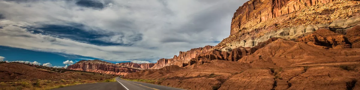
Are you planning a road trip? Start your journey in Denver, United States, and travel 401 km to Grand Junction. This scenic drive will take you fewer than 4 hours and is a great way to explore the Rockies. Along the way, you’ll pass through the historic mining towns of Central City and Black Hawk, as well as the rolling hills of the Colorado River Valley. Look out for some stunning views of the Rocky Mountains, and don’t forget to stop at the breathtaking Red Rocks Amphitheater. When you reach Grand Junction, take some time to explore the area’s wineries, breweries, and outdoor attractions. For more information, check out the “Itinerary” for this stage of your road trip. Here, you’ll find recommendations for attractions, accommodation, restaurants, and campsites. So get ready for an unforgettable road trip from Denver to Grand Junction!
 Grand Junction - United States - North America - Road Trip - Wikimedia Commons
Grand Junction - United States - North America - Road Trip - commons.wikimedia.org
❯
❮
2
Grand Junction
- Cisco
Distance 85 km
Driving time 0.9 h
Pace: fast
25.5 kWh
↓
View map
↓
Itinerary
[detailsContainer]
Embark on a breathtaking 85km journey from Grand Junction to Cisco! This scenic drive takes less than an hour and is full of history and breathtaking views. Along the way, you'll pass through winding roads and see some of the most picturesque landscapes in the region. From the historical sites to the incredible vistas, you won't want to miss a thing! Keep your eyes peeled for breathtaking views and unique attractions that you won't find anywhere else. Make sure to take photos and videos to capture the memories! Before you leave, make sure to check the "Itinerary" section of this stage for the best attractions, accommodation options, restaurants, and campsites. With a little preparation, you'll have the perfect road trip and a lifetime of memories!
Cisco - United States - North America - Road Trip - Flickr
❯
❮
3
Cisco
- Salina
Distance 250 km
Driving time 2.2 h
Pace: fast
74.9 kWh
↓
View map
↓
Itinerary
[detailsContainer]
Embark on a 250km road trip from Cisco, United States to Salina and soak in the incredible views of the landscapes along the way! This journey will take you less than 3 hours to complete, so you can make the most of your time on the road. Keep an eye out for breathtaking views of the countryside and remember to take some pictures to capture the moment.
Start your journey from Cisco and make your way to the Colorado Bend State Park, where you can explore the scenic trails and enjoy some outdoor activities. Next, you can head to the Lampasas River, a great spot for fishing and kayaking. Further down the road, you can stop at the Canyon of the Eagles, a wildlife park that allows you to observe different species of birds.
As you continue your journey, you will come across the San Saba River and the Old Fort McKavett State Historic Site, where you can learn about the history of the area. Finally, you will arrive in Salina, where you can visit the Salina Country Club and the Salina Public Library.
Be sure to take some time to enjoy the journey and marvel at the wonderful sights along the way. For more information about attractions, accommodation options, recommended restaurants, and campsites along the route, please refer to the Itinerary of this stage.
Salina - United States - North America - Road Trip - Pixabay
❯
❮
4
Salina
- Ely
Distance 357 km
Driving time 4.0 h
Pace: fast
107.2 kWh
↓
View map
↓
Itinerary
[detailsContainer]
Start your road trip from Salina, United States, and journey through the towns of Hecla, Ipswich, and Groton to reach Ely. This stage of the drive is 357 km long and is estimated to take fewer than 4 hours.
Start off your journey in Salina, a city known for its historical sites. Visit the Salina City Park, which offers swimming, picnicking, and other outdoor activities. Then, head to the Salina Aquatic Center, a popular spot for swimming and other aquatic activities.
Next, make your way to Hecla, a small town known for its beautiful countryside and outdoor activities. Here, you can explore the Hecla-Grindstone Provincial Park, which has trails for hiking and biking.
Continue your drive to Ipswich, where you can visit the Ipswich Historical Museum. This museum houses a variety of artifacts, including Native American and early settler items.
Next, make your way to Groton, home to the Groton State Forest. Here, you can explore the forest's trails, which are perfect for hiking, biking, and horseback riding.
Finally, arrive in Ely, a small town known for its outdoor activities. Here, you can explore the White Mountain National Forest, which has trails for hiking, biking, and horseback riding.
This is just one stage of a larger tour, and more information regarding attractions, accommodation options, recommended restaurants, and campsites along the route is available in the "Itinerary" of this stage. Enjoy your road trip!
Ely - United States - North America - Road Trip - www.flickr.com
❯
❮
5
Ely
- Carson City
Distance 515 km
Driving time 6.0 h
Pace: fast
154.4 kWh
↓
View map
↓
Itinerary
[detailsContainer]
Welcome to the Ely-Carson City stage of your road trip! Join us on an adventure through 515km of American landscapes and culture. Get ready to experience the beauty of nature and visit some of the most interesting places in the United States. Our journey will take us through some of the most beautiful regions of the country and will take no more than six hours of driving.
We begin our journey in Ely, where we will visit the Nevada Northern Railway Museum, a great place to learn about the history of the region. You can also explore the Bristlecone Pines Trail, a great place to take photos of the stunning landscapes.
The next stop along our journey is Carson City. Here you can visit the Nevada State Capitol, the oldest U.S. state capitol still in use. You can also explore the Nevada State Museum and the Nevada State Railroad Museum. Both are great places to learn about the history and culture of the region.
As you can see, there are plenty of things to do and see on this stage of your road trip! For more information about attractions, accommodation options, recommended restaurants, and campsites along the route, please check the “Itinerary” section of this stage.
Carson City - United States - North America - Road Trip - Vikipedija
❯
❮
6
Carson City
- South Lake Tahoe
Distance 45 km
Driving time 0.7 h
Pace: fast
13.6 kWh
↓
View map
↓
Itinerary
[detailsContainer]
Are you ready for an exciting road trip from Carson City to South Lake Tahoe? This 45km stretch of road is full of natural beauty and historical sites that will make your drive even more enjoyable.
Start your journey in Carson City, Nevada, and enjoy the captivating views of the Sierra Nevada Mountains and the Carson Valley. Make sure to check out the Nevada State Capitol, the Nevada State Museum, and the Nevada State Railroad Museum.
Once you reach South Lake Tahoe, take in the beauty of the lake itself, with its crystal clear waters and stunning snow-capped mountains. The area also offers plenty of outdoor activities, such as hiking, biking, and camping.
Along the way, you will find plenty of places to stop and explore, including the Lake Tahoe Historical Museum, the Tahoe Mountain Trails, and the Tahoe National Forest. With a driving time of fewer than 1 hour, you can easily take in the beauty of the landscape while making your way to South Lake Tahoe.
Don't forget to check out the "Itinerary" of this stage for more information on attractions, accommodation options, recommended restaurants, and campsites along the route. Enjoy your road trip!
South Lake Tahoe - United States - North America - Road Trip - pixabay.com
❯
❮
7
South Lake Tahoe
- Sacramento
Distance 165 km
Driving time 1.9 h
Pace: fast
49.5 kWh
↓
View map
↓
Itinerary
[detailsContainer]
Embark on an exciting road trip from South Lake Tahoe to Sacramento! This 165km stretch of road will take you less than two hours and is packed with plenty of amazing sights to see. Get ready to take in the breathtaking views of the Sierra Nevada mountain range, and feel the history of the area as you pass through small towns and landmarks. Some sections of the route may be closed seasonally, so be sure to check the route before you set off. The road is quite winding in some places and can be narrow in others, so stay alert and enjoy the drive! As you make your way to Sacramento, take the time to appreciate the stunning scenery and explore the many historical sites along the way. When you arrive in Sacramento, you will have plenty of opportunity to experience the sights, sounds and culture of the city. For more information on attractions, accommodation options, recommended restaurants, and campsites along the route, be sure to check the Itinerary for this stage.
Sacramento - United States - North America - Road Trip - Wikipedia
Sacramento - United States - North America - Road Trip - Wikimedia Commons
❯
❮
8
Sacramento
- San Francisco
Distance 137 km
Driving time 1.6 h
Pace: fast
41.0 kWh
↓
View map
↓
Itinerary
[detailsContainer]
Are you ready for an amazing road trip from Sacramento to San Francisco? This 137km drive will take you less than two hours, but it is full of interesting sights and interesting places to explore.
Start your journey in Sacramento, the capital of California, and make sure to visit the Governor's Mansion, the State Capitol Building, and the Old Sacramento. You will also find plenty of museums and parks in the city.
Once you hit the road, make sure to stop at the Folsom Lake State Recreation Area, where you will find plenty of activities, such as fishing, boating, and hiking. You can also explore the Folsom Powerhouse State Historic Park and the nearby lakes.
Continue your journey to San Francisco and make sure to visit the iconic Golden Gate Bridge, the Palace of Fine Arts, and the Exploratorium. You can also take a stroll along the Fisherman's Wharf, where you can enjoy the views of the bay.
As you make your way back to Sacramento, make sure to visit the historic Sonoma Valley. Here you can explore the old wineries, vineyards, and the Sonoma Plaza. Don't forget to sample some of the local wines!
For more information about attractions, accommodation options, recommended restaurants, and campsites along the route, check out the Itinerary of this stage. Get ready for an unforgettable road trip from Sacramento to San Francisco!
San Francisco - United States - North America - Road Trip - pixabay.com
❯
❮
San Francisco
[detailsContainer]
San Francisco is the perfect destination for anyone taking the "Vanishing Point Road Trip." Located in the heart of California, this vibrant city offers many attractions for travelers. With its iconic landmarks such as the Golden Gate Bridge and Alcatraz Island, as well as its famous cable cars, San Francisco is a must-see destination.
For those who are looking for a great view of the city, a walk across the Golden Gate Bridge is a must. Once on the other side, visitors can take in the panoramic views of the Bay and San Francisco. For those looking for a cultural experience, the city has many museums. Alcatraz Island is another must-see, offering visitors a glimpse into the island's past.
For outdoor enthusiasts, the city has a variety of parks and trails to explore. From the rugged trails of the Marin Headlands to the peaceful scenery of Golden Gate Park, there is something for everyone.
If you're looking for a unique experience, take a ride on one of San Francisco's famous cable cars. This is a great way to get around the city and experience the famous San Francisco hills!
For those arriving by air, the closest international airport is San Francisco International Airport (SFO). From there, travelers can rent a car or take public transportation to their destination.
San Francisco is the perfect end to the "Vanishing Point Road Trip." With its stunning views, cultural attractions, and outdoor activities, there is something for everyone to enjoy.
Vanishing Point Road Trip at a glance
-
Start:
Denver
-
End:
San Francisco
-
Distance:
1,954 km
-
Stay:
9 days
-
Getting there:
Denver International Airport (DEN),
Rocky Mountain Metropolitan Airport (BJC)
-
When to drive:
May, June, July, August, September, October
-
More info:
More info you can find in the "Itinerary" section at each stage.
 -
-