Route 1 Road Trip Itinerary
The Route 1 Road Trip is an excellent way to explore the beauty of the United States. Starting in Leggett, California and ending in Dana Point, the trip covers approximately 1227 km and is best completed in 14 days. Along the way, you will travel through Fort Bragg, Point Arena, Point Reyes, Half Moon Bay, and Monterey, experiencing the best of California's landscapes, beaches, and overall excellent road conditions. The best time to take this road trip is during the spring and summer months, when the weather is warm and sunny.
This road trip offers an unforgettable experience with memories that will last a lifetime. Even for the novice driver, the journey is manageable and provides an opportunity to explore the United States in a unique and exciting way. However, it is important to note that this road trip may require a higher budget than other trips.
Overall, the Route 1 Road Trip is an excellent way to explore the United States and experience its beauty.
 14
number of days
14
number of days
 1,227 km
route length
1,227 km
route length
 high
budget
high
budget
 family
good for
family
good for
 on the right
traffic direction
on the right
traffic direction
 moderate
accident level
moderate
accident level
START
Leggett
Distance 1,227 km
Driving time 18.8 h
Pace: fast
368.2 kWh
Airports
SFO
[detailsContainer]
Leggett, located in Northern California on the famous Route 1, is the perfect starting point for a road trip. The small town of Leggett is surrounded by breathtaking redwood forests, and is located close to a number of outdoor activities, such as hiking, mountain biking, kayaking, and fishing.
Visitors can also explore the rich culture of the area, with its many museums, galleries, and historical sites. In town, the old-fashioned Main Street is lined with unique stores, restaurants, and local businesses. For those seeking more adventure, the nearby Avenue of the Giants offers miles of winding roads through the ancient redwood trees.
The closest international airport to Leggett is San Francisco International Airport (SFO), located about 220 miles away. There are a number of car rental services available at the airport, so visitors can easily pick up a car and start their road trip.
For those looking to explore the area, there are several must-see sights in Leggett. The Standish-Hickey State Recreation Area is a beautiful park with plenty of trails and picnic spots, while the Richardson Grove State Park is home to the famous Chandelier Tree. The Usal Beach is the perfect spot to spend the day relaxing and swimming in the Pacific Ocean.
Leggett is the perfect starting point for a road trip. With its stunning redwood forests, quaint Main Street, and plenty of outdoor activities, it’s the perfect place to begin a memorable journey.
1
Leggett
- Fort Bragg
Distance 70 km
Driving time 1.4 h
Pace: modest
18.1 kWh
↓
View map
↓
Itinerary
[detailsContainer]
Are you ready for an exciting road trip from Leggett to Fort Bragg? This 43mi stage of your journey will take you fewer than 2 hours to complete, and you'll get to explore some of the most interesting places along the way.
Start your adventure in Leggett and visit the Standish-Hickey State Recreation Area, where you can enjoy a variety of outdoor activities such as camping, fishing, and hiking. Then, drive to Fort Bragg and explore the Glass Beach, a unique beach made of sea glass and other colorful stones. Other attractions in Fort Bragg include the Mendocino Coast Botanical Gardens, the Skunk Train, and the Pudding Creek Trestle.
For more information regarding attractions, accommodation options, recommended restaurants, and campsites along the route, please check the "Itinerary" of this stage. Enjoy your journey!
 Fort Bragg - United States - North America - Road Trip - Wikimedia Commons
❯
❮
2
Fort Bragg
- Mendocino
Distance 16 km
Driving time 0.2 h
Pace: fast
4.7 kWh
↓
View map
↓
Itinerary
[detailsContainer]
Are you ready for an exciting road trip from Fort Bragg to Mendocino? This 10-mile journey will take you less than an hour, but you will be able to experience the best of both cities.
In Fort Bragg, explore the historical sites such as the Guest House Museum and the Skunk Train. You can also take a stroll along the beautiful Noyo Harbor and admire its breathtaking views.
As you drive along the coast, you will be mesmerized by the stunning views of the Pacific Ocean. When you reach Mendocino, take a break and explore the charming village. Visit the Mendocino Headlands State Park and admire the rugged coastline. You can also visit the Ford House Visitor Center and learn about the cultural and natural history of the area.
On your way back, don't forget to stop at the Point Cabrillo Light Station and take in the spectacular views.
Remember to consult the "Itinerary" of this stage for more information about attractions, accommodation options, recommended restaurants, and campsites along the route. Enjoy your road trip!
Mendocino - United States - North America - Road Trip - Wikipedia
❯
❮
3
Mendocino
- Point Arena
Distance 56 km
Driving time 0.8 h
Pace: fast
16.9 kWh
↓
View map
↓
Itinerary
[detailsContainer]
Start your journey in Mendocino, a charming village in the United States, and drive 35 miles to Point Arena. In less than an hour, you will be able to enjoy the stunning views of the Pacific Ocean, the majestic redwood forests, and the quaint towns along the way.
In Mendocino, you can explore the historic Main Street, lined with galleries, boutiques, and restaurants, or take a stroll along the scenic Mendocino Headlands. After that, you can drive through the Anderson Valley and visit Boonville, a small town with wineries and breweries.
In Point Arena, you can visit the Point Arena Lighthouse, the tallest lighthouse on the West Coast of the US, and take in its breathtaking views. You can also explore the Point Arena-Stornetta Public Lands, a unique coastal area with a variety of habitats and wildlife.
This is one of the stages of a larger tour, and more information regarding attractions, accommodation options, recommended restaurants, and campsites along the route is available in the "Itinerary" of this stage. Enjoy your road trip!
Point Arena - United States - North America - Road Trip - commons.wikimedia.org
❯
❮
4
Point Arena
- Jenner
Distance 83 km
Driving time 1.3 h
Pace: fast
24.9 kWh
↓
View map
↓
Itinerary
[detailsContainer]
Welcome to the Point Arena - Jenner road trip! This is one of the stages of a larger tour, so let's get ready to explore this beautiful 52mi journey that will take you less than 2 hours to complete.
First, in Point Arena, don't miss the Point Arena Lighthouse, one of the tallest lighthouses in the US, where you can take a guided tour and learn about the history of the place. You can also visit the Arena Cove Beach, a stunning beach with amazing views of the ocean.
Continue your journey to Jenner where you can explore the Jenner Headlands Preserve, a protected area with a rich biodiversity. You can also visit the Goat Rock Beach, a beautiful beach with amazing views of the Russian River estuary.
We hope you enjoy your Point Arena - Jenner road trip and that you take advantage of all the incredible places to visit. Don't forget to check the Itinerary of this stage for more information regarding attractions, accommodation options, recommended restaurants, and campsites along the route.
Jenner - United States - North America - Road Trip - Wikimedia Commons
Jenner - United States - North America - Road Trip - Wikimedia Commons
❯
❮
5
Jenner
- Point Reyes
Distance 69 km
Driving time 1.2 h
Pace: modest
17.9 kWh
↓
View map
↓
Itinerary
[detailsContainer]
Welcome, road-trippers! Get ready for a thrilling journey from Jenner to Point Reyes. This stage of your tour covers a distance of 43mi and takes less than 2 hours to complete.
Start your journey at Jenner, where you can explore the Russian River Estuary and the Jenner Headlands Preserve. Don't forget to take a selfie with the breathtaking views of the Pacific Ocean!
Continue your drive to the north and visit the Bodega Bay. Here you can explore the Doran Regional Park and the Bodega Bay Harbor. You can also take a boat trip and admire the beautiful views of the bay.
Finally, you will reach the Point Reyes National Seashore. Here you can explore the beaches, trails, and lighthouses. Don't forget to take a stroll along the Point Reyes Lighthouse Trail and enjoy the breathtaking views of the ocean.
For more information about attractions, accommodation options, recommended restaurants, and campsites along the route, you can check the "Itinerary" of this stage. Enjoy your road trip!
Point Reyes - United States - North America - Road Trip - Wikimedia Commons
❯
❮
6
Point Reyes
- San Francisco
Distance 65 km
Driving time 1.0 h
Pace: fast
19.4 kWh
↓
View map
↓
Itinerary
[detailsContainer]
Embark on an unforgettable road trip starting in the Point Reyes National Seashore, United States and ending in San Francisco. This 40 mi (64 km) journey will take you less than an hour to complete, and you can expect to be mesmerized by some of the most beautiful landscapes and historical sites in the area.
Start your adventure in Point Reyes, a place of wild beauty, where you can explore the beaches, lighthouses, and trails. Then, make your way to Olema, a small village with a unique history that includes the Miwok people.
Continue on to the small town of Bolinas, where you can enjoy the stunning views of the Pacific Ocean and its untouched beaches. As you drive through Stinson Beach, take in the breathtaking views of the majestic redwoods and the rugged coastline.
Finally, arrive in San Francisco, the city by the bay, where you can explore the iconic Golden Gate Bridge, the bustling Fisherman’s Wharf, and the historic Alcatraz Island.
Remember, more information regarding attractions, accommodation options, recommended restaurants, and campsites along the route is available in the "Itinerary" of this stage. So, don't forget to check it out before you embark on your road trip!
San Francisco - United States - North America - Road Trip - pixabay.com
❯
❮
7
San Francisco
- Half Moon Bay
Distance 44 km
Driving time 0.8 h
Pace: modest
11.4 kWh
↓
View map
↓
Itinerary
[detailsContainer]
Welcome to the San Francisco to Half Moon Bay road trip stage! This is a 27mi journey that will take you less than 1 hour to complete.
Start your journey in San Francisco, the City by the Bay. Here you can find iconic landmarks such as the Golden Gate Bridge and the famous prison island, Alcatraz. Don't forget to visit the Exploratorium, a science museum and educational center with interactive exhibits.
Continue your drive to Half Moon Bay, a small coastal town surrounded by the Pacific Ocean. Here you can explore the beautiful beaches, such as the famous Mavericks Beach and the Pillar Point Harbor. The Fitzgerald Marine Reserve is also a great spot to observe the local wildlife.
This is just one stage of a larger tour, so make sure to check out the "Itinerary" for more information about attractions, accommodation options, recommended restaurants, and campsites along the route. Enjoy your journey!
Half Moon Bay - United States - North America - Road Trip - Wikimedia Commons
❯
❮
8
Half Moon Bay
- Santa Cruz
Distance 77 km
Driving time 1.0 h
Pace: fast
23.1 kWh
↓
View map
↓
Itinerary
[detailsContainer]
Welcome to the Half Moon Bay to Santa Cruz road trip stage! This 48mi scenic drive takes you from the breathtaking beaches of Half Moon Bay to the lively city of Santa Cruz. Along the way, you will be mesmerized by the picturesque landscapes of the Pacific coast. Make sure to take your time and take in all the beauty that this route has to offer.
Start your journey in Half Moon Bay and make your way to the iconic Pillar Point Harbor. Here, you can observe the amazing view of the Pacific Ocean and, if you're lucky, spot some whales. Then, take a stroll on the beach and enjoy the fresh air.
Continue your drive to Santa Cruz, where you can explore the Santa Cruz Beach Boardwalk. This amusement park is the perfect place to spend the day with friends and family. If you're feeling adventurous, you can even ride the Giant Dipper, the historic wooden roller coaster.
Finally, make your way to the Santa Cruz Wharf and take a walk along the beach. Here, you can observe the boats, enjoy the views, and grab a bite to eat at one of the many restaurants.
For more information about attractions, accommodation options, recommended restaurants, and campsites along the route, be sure to check out the Itinerary for this stage. Enjoy your road trip!
Santa Cruz - United States - North America - Road Trip - commons.wikimedia.org
❯
❮
9
Santa Cruz
- Monterey
Distance 72 km
Driving time 0.8 h
Pace: fast
21.7 kWh
↓
View map
↓
Itinerary
[detailsContainer]
Are you ready for an amazing road trip? Then let's go! Starting in Santa Cruz, you will travel for about 45 miles and in less than an hour you will arrive in Monterey. Along the way, you will be able to enjoy breathtaking views of the Pacific Ocean, the Santa Cruz Mountains and the redwood forests. Make sure you don't miss the historical sites, such as the Mission Santa Cruz or the Lighthouse at Point Pinos. You can also stop and take some pictures at the Monterey Bay National Marine Sanctuary. And don't forget to visit the Monterey Bay Aquarium! This is just one of the stages of your journey, so make sure to check the "Itinerary" for more information about attractions, accommodation, restaurants, and campsites. Enjoy your road trip!
Monterey - United States - North America - Road Trip - Wikipedia
Monterey - United States - North America - Road Trip - www.needpix.com
❯
❮
10
Monterey
- Big Sur
Distance 47 km
Driving time 0.7 h
Pace: fast
14.0 kWh
↓
View map
↓
Itinerary
[detailsContainer]
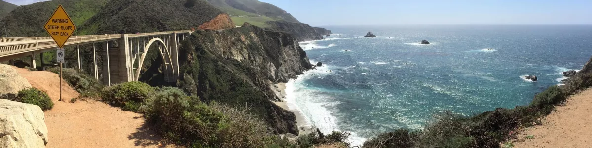
Embark on an unforgettable road trip from Monterey to Big Sur! This 29-mile journey will take you less than an hour to complete, and you’ll be in awe of the majestic views along the way. Start your journey in Monterey, the home of Cannery Row and the Monterey Bay Aquarium. Take a stroll along the harbor and enjoy the picturesque views of the bay. As you make your way to Big Sur, you’ll be in awe of the stunning views of the Pacific Ocean, the rugged cliffs and the awe-inspiring redwood forests. Stop at Point Lobos State Natural Reserve for a chance to observe California’s diverse wildlife and explore the many hiking trails. Don’t forget to make a stop at the iconic Bixby Creek Bridge, the most photographed bridge in California. As you make your way to Big Sur, you’ll be surrounded by the majestic beauty of the Santa Lucia Mountains. Make sure you take some time to explore the many beaches and parks that the area has to offer. To find out more about attractions, accommodation options, recommended restaurants, and campsites along the route, please refer to the “Itinerary” of this stage.
Big Sur - United States - North America - Road Trip - www.flickr.com
❯
❮
11
Big Sur
- Cambria
Distance 118 km
Driving time 1.7 h
Pace: fast
35.5 kWh
↓
View map
↓
Itinerary
[detailsContainer]
The Big Sur to Cambria road trip is one of the most scenic drives you can take in the United States. Stretching 74 miles along the California coast, it's the perfect way to take in the beauty of the Pacific Ocean. Along the way, you'll pass through some of the most iconic landmarks that the state has to offer. Start your journey in Big Sur, where you can explore the breathtaking McWay Falls, or take a stroll along the rugged coastline. Then, continue on to the historic Hearst Castle, a magnificent estate built by newspaper magnate William Randolph Hearst. Next, make your way to the town of Cambria, where you can explore Moonstone Beach and the charming shops and restaurants of the downtown area. With a driving time of fewer than two hours, this is a great way to experience some of the best of California in a single day. For more information on attractions, accommodation options, recommended restaurants, and campsites along the route, check out the "Itinerary" of this stage.
Cambria - United States - North America - Road Trip - Wikimedia Commons
❯
❮
12
Cambria
- San Luis Obispo
Distance 52 km
Driving time 0.6 h
Pace: fast
15.7 kWh
↓
View map
↓
Itinerary
[detailsContainer]
Welcome to the incredible road trip stage between Cambria and San Luis Obispo! This 33-mile journey will take you less than an hour to complete, but you'll want to take your time and enjoy the breathtaking views of the Pacific coast. Start your trip in Cambria, a picturesque seaside village with a rich history that is sure to delight! Take a stroll along Moonstone Beach, or explore the many art galleries and shops in the downtown area. From there, head south to San Luis Obispo, a charming city full of culture and natural beauty. Visit the Mission San Luis Obispo de Tolosa, and don't forget to take a selfie with the iconic Madonna Inn sign! Take a break from your drive to explore the many hiking and biking trails in the area. As you make your way through this stage of your journey, don't forget to take in the stunning views of the rolling hills and the Pacific Ocean. For more information about attractions, accommodation options, recommended restaurants, and campsites along the route, please refer to the Itinerary of this stage. Enjoy your trip!
San Luis Obispo - United States - North America - Road Trip - Wikimedia Commons
❯
❮
13
San Luis Obispo
- Gaviota
Distance 153 km
Driving time 1.9 h
Pace: fast
45.9 kWh
↓
View map
↓
Itinerary
[detailsContainer]
Welcome to the San Luis Obispo to Gaviota road trip! This stage of your journey is 95mi long and should take you fewer than 2 hours to complete.
Start your journey in San Luis Obispo, a vibrant city with plenty of attractions like the Mission San Luis Obispo de Tolosa, the Bubblegum Alley and the beautiful beaches of Pismo.
Continue your journey and stop by the Avila Valley Barn, a family-owned farm where you can buy fresh produce, have a delicious lunch and even go on a hayride.
Further down the road, you will find the beautiful city of Santa Barbara. Take a break to explore the Santa Barbara Mission, the Santa Barbara Zoo and the Stearns Wharf.
Finally, you will reach Gaviota, a small town with a lot of history. Here you can explore the Gaviota State Park, the Gaviota Beach and the Gaviota Hot Springs.
For more information regarding attractions, accommodation options, recommended restaurants, and campsites along the route, please check the "Itinerary" of this stage. Enjoy your road trip!
Gaviota - United States - North America - Road Trip - Wikipedia
❯
❮
14
Gaviota
- Santa Barbara
Distance 52 km
Driving time 0.5 h
Pace: fast
15.5 kWh
↓
View map
↓
Itinerary
[detailsContainer]
Start your road trip in Gaviota, a small town in the United States, and drive to Santa Barbara, a 32 mi journey that will take you less than an hour. During your drive, you will get to explore some of the most interesting places in these two places. In Gaviota, you can visit the Hollister Ranch, a private ranch with 8.5 miles of beachfront and a variety of activities to enjoy. The Gaviota State Park is also a great place to explore and take in the beautiful nature. In Santa Barbara, you can visit the Santa Barbara Mission, the oldest of the California missions, and the Santa Barbara Zoo, which is home to over 500 animals. Also, don't miss out on the Santa Barbara County Courthouse, a beautiful historic building in the city. For a more relaxed atmosphere, take a stroll along the Santa Barbara waterfront and enjoy the views of the harbor. More information about attractions, accommodation options, recommended restaurants, and campsites along the route is available in the "Itinerary" of this stage. So, don't miss out on this amazing road trip and explore Gaviota and Santa Barbara!
Santa Barbara - United States - North America - Road Trip - Max Pixel
❯
❮
15
Santa Barbara
- Malibu
Distance 108 km
Driving time 1.3 h
Pace: fast
32.4 kWh
↓
View map
↓
Itinerary
[detailsContainer]
Are you ready for an exciting road trip through Santa Barbara and Malibu? Get ready for a journey of 67 miles and less than two hours of driving time! Start your journey in Santa Barbara, a coastal city with a Mediterranean climate, and explore its beautiful beaches, historic sites, and the nearby Santa Ynez Mountains. Visit the renowned Santa Barbara Mission, the Old Mission Santa Barbara, and the Santa Barbara Zoo. Don’t forget to explore the lively downtown area with its numerous shops, restaurants, and art galleries.
Continue your journey to Malibu, a stunning beach town with a laid-back atmosphere. Take some time to explore the beautiful beaches and visit the Malibu Lagoon State Beach, Surfrider Beach, and Zuma Beach. Shop and dine in the charming Malibu Country Mart and explore the nearby Santa Monica Mountains.
This is just one of the many stages of this amazing tour. For more information regarding attractions, accommodation options, recommended restaurants, and campsites along the route, please check the "Itinerary" of this stage. Have a great journey!
Malibu - United States - North America - Road Trip - Wikimedia Commons
❯
❮
16
Malibu
- Santa Monica
Distance 28 km
Driving time 0.5 h
Pace: fast
8.5 kWh
↓
View map
↓
Itinerary
[detailsContainer]
Welcome to the Malibu to Santa Monica road trip stage! This beautiful journey along the Pacific Coast Highway will take you through some of the most stunning landscapes in California. You'll be amazed by the breathtaking views of the Pacific Ocean and the Malibu mountains. You'll also have the chance to explore the historical sites of Malibu and Santa Monica, and experience the local culture.
The road trip is only 18 miles long and will take you less than an hour to complete. As you drive, be sure to keep an eye out for the historical sites, such as the Adamson House and the Malibu Pier. In Santa Monica, make sure to visit the Santa Monica Pier and the Third Street Promenade for some of the best shopping and dining in the area.
This road trip is just one part of a larger tour. For more information on attractions, accommodation options, recommended restaurants, and campsites along the route, please refer to the Itinerary of this stage. Enjoy your journey!
Santa Monica - United States - North America - Road Trip - pxhere.com
❯
❮
17
Santa Monica
- Los Angeles
Distance 32 km
Driving time 1.0 h
Pace: slow
7.3 kWh
↓
View map
↓
Itinerary
[detailsContainer]
Welcome road-trippers! Get ready for an exciting journey from Santa Monica to Los Angeles! This 20-mile drive takes a little less than one hour, so you will have plenty of time to take in the sights along the way.
Start your journey in Santa Monica, a vibrant beach city with a lively pier, beautiful beaches, and plenty of unique shops and restaurants. As you drive south, you will pass through the affluent communities of Brentwood and Bel Air, with their stunning mansions and lush gardens.
In Los Angeles, you will find a wealth of attractions, from the Hollywood Walk of Fame to the stunning Getty Museum. For an outdoor adventure, take a stroll through Griffith Park, one of the largest urban parks in the United States.
Along the way, you will be treated to picturesque views of the Pacific Ocean and the Santa Monica Mountains. Be sure to keep your eyes open for historical sites and other interesting attractions.
For more information about attractions, accommodation options, recommended restaurants, and campsites along the route, please consult the Itinerary for this stage. Enjoy your journey!
Los Angeles - United States - North America - Road Trip - Wikipedia
Los Angeles - United States - North America - Road Trip - Wikipedia
Los Angeles - United States - North America - Road Trip - www.flickr.com
❯
❮
18
Los Angeles
- Laguna Beach
Distance 71 km
Driving time 1.8 h
Pace: modest
18.5 kWh
↓
View map
↓
Itinerary
[detailsContainer]
Are you ready for an amazing road trip from Los Angeles to Laguna Beach? This spectacular journey will take you 44 miles (less than 2 hours of driving) and will show you some of the most beautiful places in the US.
As you leave Los Angeles, you can make a stop at the iconic Hollywood Sign and take pictures. Then, you can visit the Griffith Observatory and admire the views of the city from the top of the hill.
Once you reach Malibu, you must visit the stunning Malibu Lagoon State Beach and take a walk along the shore. After that, you can go to the Malibu Pier and take a break.
As you approach Laguna Beach, you can stop at the Crystal Cove State Park and take a stroll along the beach. Finally, you can admire the breathtaking views of the Pacific Ocean from the Heisler Park.
This is only one of the stages of a larger tour, and more information about attractions, accommodation options, recommended restaurants, and campsites along the route is available in the "Itinerary" of this stage. So, what are you waiting for? Get ready for your Los Angeles to Laguna Beach road trip!
Laguna Beach - United States - North America - Road Trip - commons.wikimedia.org
❯
❮
19
Laguna Beach
- Dana Point
Distance 14 km
Driving time 0.4 h
Pace: slow
3.3 kWh
↓
View map
↓
Itinerary
[detailsContainer]
Embark on an unforgettable road trip from Laguna Beach to Dana Point! This 9mi journey will take you less than an hour, making it the perfect stage of your larger tour.
Start your journey in Laguna Beach, where you can explore the town’s many art galleries, shops, and restaurants. Don’t miss the stunning beaches, such as Main Beach, Thousand Steps Beach, and Crescent Bay Beach.
Continue your drive to Dana Point, where you can take a stroll along the harbor and visit the Ocean Institute. Dana Point also offers a variety of restaurants, parks, and trails.
For more information on attractions, accommodation options, recommended restaurants, and campsites along this route, check out the “Itinerary” section of this stage. Enjoy your journey!
Dana Point - United States - North America - Road Trip - Wikimedia Commons
❯
❮
Dana Point
[detailsContainer]
Dana Point, located in Orange County, California, is the perfect ending point for a “Route 1 Road Trip”. Home to some of the most stunning beaches in the area, Dana Point is a great place to get some rest and relaxation after a long road trip.
The harbor of Dana Point is an ideal place for a stroll and to enjoy the many shops and restaurants that line the harbor. Visitors can also take a boat tour of the harbor and get a closer look at the local marine life.
Dana Point is also home to several parks, including the Dana Point Headlands Conservation Park and the Dana Point Nature Interpretive Center. Here, visitors can take a hike along the trails and take in the beautiful views of the Pacific Ocean.
At the end of the day, visitors can enjoy the nightlife of Dana Point. From local bars and restaurants, to live music and nightlife, Dana Point has something for everyone.
The closest international airport to Dana Point is the John Wayne Airport (SNA) in Santa Ana, California. From here, visitors can rent a car to take them the rest of the way to Dana Point and begin their “Route 1 Road Trip”.
Dana Point is the perfect ending point for a “Route 1 Road Trip”. With its stunning beaches, parks, and nightlife, visitors will find plenty to keep them entertained and relaxed after a long journey.
Route 1 Road Trip at a glance
-
Start:
Leggett
-
End:
Dana Point
-
Distance:
1,227 km
-
Stay:
14 days
-
Getting there:
San Francisco International Airport (SFO)
-
When to drive:
January, February, March, April, May, June, July, August, September, October, November, December
-
More info:
More info you can find in the "Itinerary" section at each stage.
Before you set off
The California State Route 1, commonly known as Highway 1, offers an iconic Road Trip from Leggett to Dana Point, spanning approximately 1227 km (762 miles) of the Pacific Coast. This quintessential journey affords travelers a chance to immerse themselves in California's varied landscapes, from rugged cliffs and serene beaches to lush forests and rolling hills. Ideal for a leisurely exploration, the Trip can be comfortably completed over two weeks, allowing for ample time to soak in the natural beauty and cultural experiences along the way. Both experienced Roadtrippers and first-timers will find this route an exhilarating and unforgettable adventure.
Key Destinations and Top Sights:
- Fort Bragg: Discover the mesmerizing Glass Beach, strewn with colorful sea glass, and take a ride on the historic Skunk Train through majestic redwood forests.
- Point Arena: Visit the Point Arena Lighthouse, the tallest lighthouse on the Pacific Coast, offering panoramic views and an opportunity to spot migrating whales.
- Point Reyes: Explore the Point Reyes National Seashore, a sanctuary for a multitude of wildlife species, including elephant seals, tule elk, and myriad bird species, amidst dramatic landscapes.
- Half Moon Bay: Relax at pristine beaches, and if you're a surfing enthusiast, catch a glimpse of the world-renowned Maverick’s surf competition.
- Monterey: Delve into the underwater wonders at the Monterey Bay Aquarium, and take a Scenic Drive along the famous 17-Mile Drive, with its stunning coastal vistas and legendary golf courses.
Best Time to Go:
The prime months to embark on the Route 1 Road Trip are from late spring to early fall (May through October), when the weather is typically mild and sunny, providing ideal conditions for outdoor activities and sightseeing.
Potential Risks:
Travelers should be mindful of potential hazards like landslides and Road closures, which are more frequent during the rainy season (November to April). The serpentine nature of Highway 1 along the coast also demands attentive driving.
Interesting Facts for Roadtrippers:
The route is renowned for its excellent Road conditions and captivating views at every turn, catering to drivers with varying levels of experience. Notably, Highway 1 is also a part of the California Coastal National Monument, which means you'll be driving through a nationally recognized area of importance for its ecological, cultural, and scenic values. Nonetheless, it's wise to plan your budget carefully; the Trip can be more expensive due to the tourist-oriented nature of many coastal towns.
A good choice for:
The Highway 1 Road Trip weaves together elements of thrill, tranquility, and the opportunity to forge unforgettable memories against the backdrop of California's unparalleled coastal splendor. Whether it's the thrill of navigating the Bixby Creek Bridge's sweeping curves, the tranquility of a sunset at Big Sur, or the taste of fresh seafood in a coastal village, this journey is a testament to the diverse and vibrant spirit of California.
 -
-