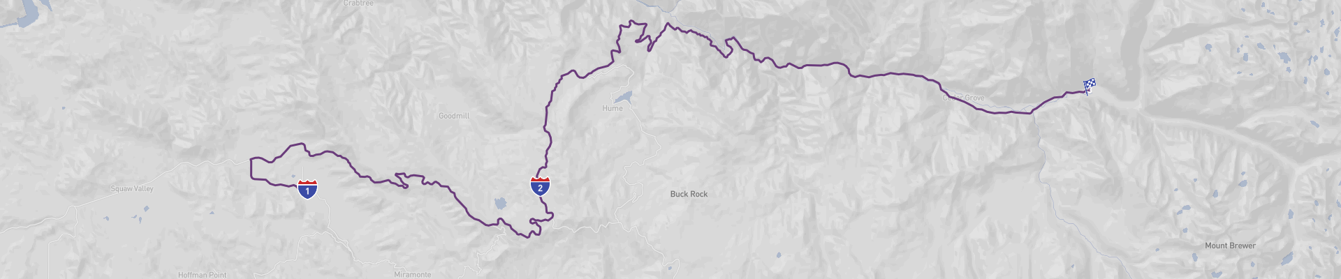
Kings Canyon Panoramic Road Itinerary
Take a journey through the majestic Kings Canyon National Park on the Kings Canyon Panoramic Road. Starting in Dunlap, California, this 91km road trip takes you through Grant Grove Village and into the heart of Kings Canyon National Park. Along the way, you’ll experience stunning landscapes of towering mountain peaks and verdant valleys. The best time to drive this route is from April to October, when the weather is mild and the roads are in excellent condition. This road trip is suitable for all drivers, and can be done on a moderate budget. Enjoy a day of adventure and breathtaking views that will leave you with memories to treasure for a lifetime.
 1
number of days
1
number of days
 91 km
route length
91 km
route length
 fair
budget
fair
budget
 family
good for
family
good for
 on the right
traffic direction
on the right
traffic direction
 low
accident level
low
accident level
START
Dunlap
Distance 91 km
Driving time 1.6 h
Pace: modest
23.6 kWh
Airports
FAT
[detailsContainer]
Dunlap is a small town in California, USA. It is an ideal starting point for the Kings Canyon Panoramic Road, a scenic road trip that takes you through some of the most picturesque landscapes in the country. The first stop in Dunlap should be the Dunlap Community Park, a park with a playground, a pond, and a picnic area. From here, you can continue your journey to Kings Canyon National Park.
The next stop on the road trip is the Sequoia National Forest. This forest is home to some of the world’s oldest and largest trees, including the giant sequoias. The area is also home to numerous hiking trails, waterfalls, and swimming holes.
The closest international airport to Dunlap is Fresno Yosemite International Airport (FAT). Car rentals are available at the airport, making it easy to start your road trip from Dunlap.
Dunlap is a great place to start your road trip and explore the beauty of California. There are plenty of outdoor activities to enjoy, from hiking in the Sequoia National Forest to swimming in the ponds in Dunlap Community Park. With its convenient location, Dunlap is the perfect place to start your road trip along the Kings Canyon Panoramic Road.
1
Dunlap
- Grant Grove Village
Distance 35 km
Driving time 0.6 h
Pace: modest
9.2 kWh
↓
View map
↓
Itinerary
[detailsContainer]
Are you ready for a spectacular road trip from Dunlap to Grant Grove Village? Get ready for an adventure of 22 miles that will take you less than 1 hour! You will be driving through some of the most scenic roads, with winding sections and narrow roads. Be sure to keep your eyes open for interesting sights. Once you arrive at Grant Grove Village, you will be able to explore the area and find out more about the attractions and activities available. There are plenty of accommodation options, restaurants, and campsites to choose from. For more information, please check the Itinerary of this stage. So, fasten your seatbelts and let's hit the road!
 Grant Grove Village - United States - North America - Scenic Drive - National Park Service
❯
❮
2
Grant Grove Village
- Kings Canyon N.P.
Distance 55 km
Driving time 1.0 h
Pace: modest
14.3 kWh
↓
View map
↓
Itinerary
[detailsContainer]
Embark on a 34mi road trip from Grant Grove Village to Kings Canyon National Park and get ready for a scenic drive! You will be able to spot picturesque landscapes, winding roads, and narrow sections of the route. Please note that some sections may be closed seasonally, so make sure to check the itinerary before heading off. Once you arrive at your destination, you will be able to explore the beauty of Kings Canyon National Park. Here you can find a variety of attractions, accommodation options, recommended restaurants, and campsites. Make sure to check the itinerary for more details and have a great road trip!
Kings Canyon N.P. - United States - North America - Scenic Drive - Wikipedia
❯
❮
Kings Canyon N.P.
[detailsContainer]
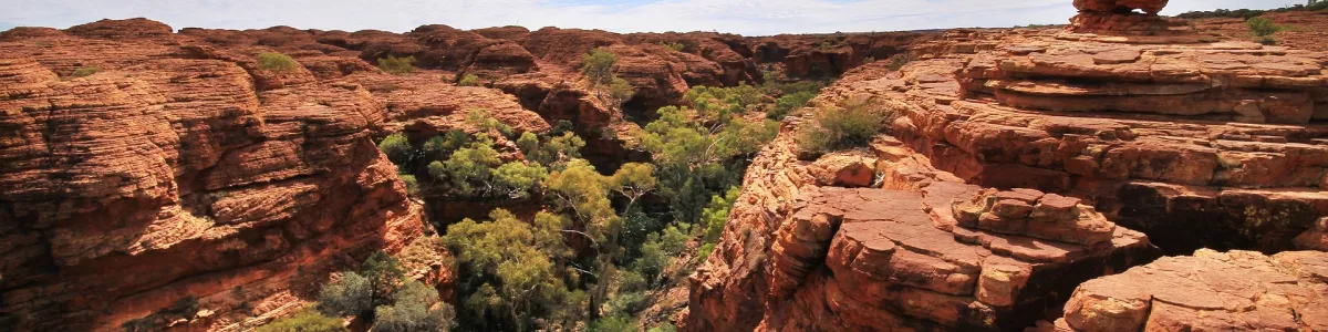
Kings Canyon National Park is a spectacular destination for all nature lovers and road-trippers alike. Located in California’s southern Sierra Nevada, its awe-inspiring landscape is characterized by a number of deep canyons, majestic mountain peaks, and a variety of lush forests. Its majestic beauty is best experienced by taking the Kings Canyon Panoramic Road, a scenic road trip that winds through the park's varied terrain.
The Kings Canyon Panoramic Road begins at the Cedar Grove Visitor Center and ends in Grant Grove, a grove of giant sequoias. Along the way, visitors will find plenty of opportunities to explore and take in the park's stunning scenery. There are numerous trails leading to breathtaking waterfalls, giant sequoias, and breathtaking overlooks. For those looking to get off the beaten path, there are plenty of backcountry trails that lead to some of the park's most remote and beautiful areas.
No visit to Kings Canyon is complete without a stop in Grant Grove, home to some of the world’s largest and oldest sequoias. Here, visitors can explore a variety of trails that lead to incredible views of the massive trees. For those looking to get up close and personal, the Big Stump Trail offers a unique chance to walk among the giant sequoias.
For those traveling by air, the closest international airport is Fresno Yosemite International Airport (FAT). From there, it’s a two-hour drive to the park. So, why not make the Kings Canyon Panoramic Road your next road trip destination? With its breathtaking scenery, diverse wildlife, and majestic sequoias, Kings Canyon National Park is a must-see for any nature lover.
Kings Canyon Panoramic Road at a glance
-
Start:
Dunlap
-
End:
Kings Canyon N.P.
-
Distance:
91 km
-
Stay:
1 day
-
Getting there:
Fresno Yosemite International Airport (FAT)
-
When to drive:
May, June, July, August, September, October
-
More info:
More info you can find in the "Itinerary" section at each stage.
Before you set off
Embark on the Kings Canyon Scenic Byway, a breathtaking 56.7-mile (91km) journey that begins in Dunlap, California. This route takes travelers through the heart of the Sierra Nevada, with a stop at the charming Grant Grove Village before descending into the awe-inspiring Kings Canyon National Park. Here, you'll be greeted by dramatic landscapes, including towering mountains, deep gorges, and serene meadows.
Key Destinations and Top Sights:
- Grant Grove Village: This quaint area serves as a gateway to majestic sequoias and is home to the iconic General Grant Tree, also known as `The Nation's Christmas Tree,` which stands as the world's second-largest tree by volume.
- Kings Canyon National Park: The park boasts breathtaking geological formations, from the sheer walls of Kings Canyon itself— one of the deepest canyons in North America—to the serene beauty of Zumwalt Meadow. Take in the views from scenic overlooks, explore subterranean wonders at Boyden Cavern, and marvel at the powerful Kings River carving its way through the valley.
Best Time to Go:
The prime time to enjoy this Scenic Drive is between late spring and early fall, from April to October. These months offer the best conditions for Road access and outdoor activities, with wildflowers blooming in the spring and the vibrant fall colors on display in the autumn.
Potential Risks:
- Traveling outside the ideal window of April to October may result in encountering snow, ice, or fallen debris that could close Roads or create challenging driving conditions.
- Keep an eye out for wildlife such as bears and deer that may unexpectedly cross the Road, especially at dawn and dusk.
Facts for Roadtrippers:
The scenic byway is accessible to drivers of all experience levels, with clear signage and pull-outs for enjoying the views.
You can experience this Trip on a moderate budget, with various accommodation options and affordable park entry fees.
Kings Canyon National Park provides a plethora of outdoor activities for all interests, from leisurely nature walks and picnicking to more adventurous pursuits like hiking to Mist Falls or backcountry camping.
A good choice for:
The Kings Canyon Panoramic Road Trip offers a blend of accessibility and wilderness adventure. Whether you're looking for a tranquil retreat or an exhilarating exploration, the journey along this scenic byway is filled with natural grandeur and opportunities for discovery, ensuring that your day on the Road is packed with adventure and beauty, leaving you with memories that will last a lifetime.
 -
-