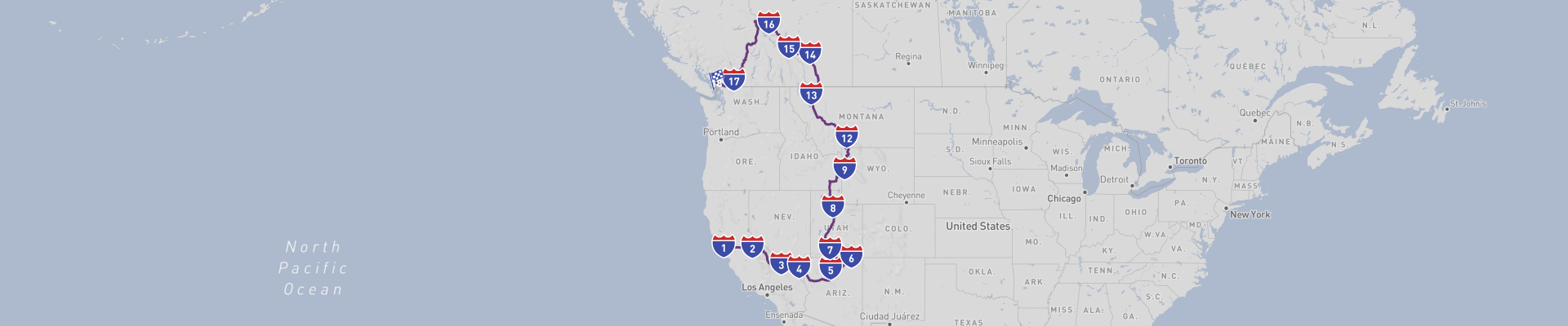
Through Western USA and Canada Road Trip Itinerary
Through Western USA and Canada Road Trip is an epic 21-day journey of about 5511km that takes you from the Pacific vibes of San Francisco all the way to coastal Vancouver, crossing some of North America’s most iconic landscapes. The best time to drive this route is from late May to late September, when most mountain passes are open, days are long, and weather is generally stable, though summer heat in the deserts and crowds in top parks should be expected.
Starting in San Francisco, you roll out from the Golden Gate, steep streets, and waterfront piers into California’s interior. Before leaving, it’s worth walking along the Embarcadero, checking out Fisherman’s Wharf, or crossing the Golden Gate Bridge for views over the bay and Alcatraz. As you head east, the city’s cool ocean air gives way to warmer inland temperatures and more rural scenery, with vineyards, orchards, and golden hills leading you toward the Sierra Nevada mountains.
Yosemite National Park comes up as one of the big highlights of the trip. This is one of the most famous national parks in the United States, known for sheer granite walls, waterfalls, and giant sequoias. In Yosemite Valley you’ll find must-see sights like El Capitan, Half Dome, Yosemite Falls, and Bridalveil Fall. Glacier Point offers one of the best panoramas over the valley, while Mariposa Grove showcases massive sequoia trees that can be thousands of years old. The park is not a UNESCO site, but it has a similar level of global recognition and feels like an open-air museum of glacial geology. In peak season, parking and traffic can be heavy, so arriving early in the day and using shuttle services where available is very helpful.
Continuing southeast, the landscapes turn drier and more desert-like as you approach Nevada. Las Vegas appears out of the desert as a full-on contrast to the national parks. Here, the Strip is the main attraction, a long line of themed hotels, casinos, shows, and neon lights. You can walk between resorts like the Bellagio (famous for its fountains), the Venetian, and Caesars Palace, or head up the Stratosphere Tower for city and desert views. Off the Strip, the Fremont Street Experience in downtown Las Vegas gives a slightly grittier, old-school vibe with a massive LED canopy overhead. Nearby natural escapes like Red Rock Canyon offer hiking and scenic drives if you need a break from the city. Las Vegas is also a good place to refuel, restock, and have the car checked before heading deeper into remote territory.
Driving east again, you gradually leave the full-on city experience and return to big sky country. Monument Valley National Park, on the Arizona–Utah border, is one of the classic images of the American West: red sandstone buttes rising straight from the desert floor. The scenic drive through the valley (often on a rougher road) gives you close views of formations like the Mittens and Merrick Butte. This is Navajo Nation land, and guided tours led by local Native American guides can give more context to the landscape and its cultural significance. Sunrise and sunset are the best times for color and photos, with the rock glowing deep red and orange. Monument Valley is not a UNESCO site, but it’s one of the most photographed places in the region and a must-see stop for its cinematic landscapes and sense of space.
From here, the route bends north through Utah’s plateaus and canyon country, then toward the more temperate climate of northern Utah. Salt Lake City sits between the Great Salt Lake and the Wasatch Range, combining a relatively compact downtown with easy access to mountains. The central Temple Square is the historical and spiritual core of the city, with the Salt Lake Temple and visitor centers describing the history of the Church of Jesus Christ of Latter-day Saints. The nearby State Capitol and City Creek area are pleasant to walk, and if you have time, driving up one of the nearby canyons (like Big Cottonwood or Little Cottonwood) gives quick access to alpine scenery. This city is a good mid-route service hub: garages, supplies, and accommodations are plentiful, making it a logical place for a more serious rest day or car check before heading back into higher, more remote terrain.
As you head north and slightly east, the mountains get higher and greener until you reach Grand Teton National Park in Wyoming. This park is known for its jagged mountain range that rises sharply from the valley floor without foothills, making for dramatic views. The main must-see attractions here include Jenny Lake, with its boat rides and hikes up toward Hidden Falls and Inspiration Point, and the viewpoints along Teton Park Road and the Snake River, where reflections of the peaks on calm mornings are a classic photo subject. Mormon Row Historic District, with its old barns and open meadows, is another popular spot, especially at sunrise. While Grand Teton is not a UNESCO World Heritage site, its scenery is world-class, and wildlife watching is excellent: moose, elk, bison, and occasionally bears can be seen, especially early and late in the day. This is a place where you feel the scale of the Rockies before you head into the long drive north toward Canada.
The journey from the Tetons to the Canadian border covers long distances through a mix of high plains, forests, and smaller mountain ranges. You’ll pass through rural towns and mid-size cities where you can refuel, grab food, and break the drive into manageable legs. As you continue north, keep an eye on weather forecasts; storms can move quickly in open country, and winds can be strong on exposed highways. Approaching the Canadian border, you’ll need to have your travel documents ready and be aware of customs regulations, especially regarding food, alcohol, and any outdoor gear like bear spray.
Once in Canada, roads lead you through southern British Columbia, where mountain scenery, forests, and lakes become more frequent as you near the coast. Depending on your exact route, you might pass near areas with national or provincial parks, waterfalls, and scenic rivers, each offering viewpoints and short walks to stretch your legs. Distances can still be significant between towns, so keeping your gas tank topped up and watching for wildlife along the roadside (especially at dawn and dusk) is important. The approach to Vancouver brings you gradually back to more urban surroundings, with larger communities, more traffic, and a noticeable shift back to coastal humidity and milder temperatures.
Vancouver, your endpoint, is a coastal city framed by water and mountains. Must-see attractions here include Stanley Park with its seawall and forest trails, the lively Granville Island Public Market, and neighborhoods like Gastown and Yaletown for food and nightlife. On clear days, viewpoints around the city and nearby mountains like Grouse or Cypress give you a final set of big vistas to close out the road trip. Vancouver is also a place where you can easily return the car, arrange onward travel, and enjoy a slower pace after long days on the road.
Along this entire route there are no UNESCO World Heritage Sites directly on the classic road corridor itself, but you skirt or approach areas of very high natural value that could be combined with short detours if you have extra time. The core must-see attractions on the main line of the trip are Yosemite’s granite peaks and waterfalls, the lights and shows of Las Vegas, the red monoliths of Monument Valley, the cultural and urban stop in Salt Lake City, the rugged skyline of Grand Teton, and the coastal-meets-mountain atmosphere of Vancouver. Together, they create a strong contrast between wilderness, desert, mountains, and big cities.
Road conditions across this roughly 5511km route are generally good, with well-maintained highways in both the United States and Canada. However, there are a few things to keep in mind: in summer, desert segments around Nevada, Utah, and Arizona can be extremely hot, so engine cooling, tires, and hydration for passengers are important. In mountain areas (Sierra Nevada, Tetons, and parts of British Columbia), weather can change quickly, and even late spring or early autumn may bring snow at higher elevations or on mountain passes. Wildlife on the road is a real risk in rural and forested sections, especially deer and larger animals at night and near dawn or dusk, so driving more slowly in those times is wise. In and around national parks and big cities, traffic can be heavy, and parking may be limited; planning your driving times to avoid the busiest hours helps a lot. Finally, distances between services can be long in parts of Nevada, Utah, Wyoming, and interior British Columbia, so keeping fuel levels high, carrying water, and checking road and weather updates regularly will make this ambitious 21-day Western USA and Canada road trip smoother and safer.
 21
number of days
21
number of days
 5,511 km
route length
5,511 km
route length
 high
budget
high
budget
 family
good for
family
good for
 on the right
traffic direction
on the right
traffic direction
 moderate
accident level
moderate
accident level
START
San Francisco
Distance 5,511 km
Driving time 68.0 h
Pace: fast
1,653.4 kWh
Airports
SFO
,
OAK
[detailsContainer]
San Francisco is an awesome kick-off city for the
Through Western USA and Canada Road Trip. It packs big-city vibes into a small, easy-to-drive area, with killer views almost everywhere you look.
Top sights you shouldn’t skip:
- Golden Gate Bridge – Drive it, walk it, or hit the viewpoints at Battery Spencer or Crissy Field for classic photos.
- Fisherman’s Wharf & Pier 39 – Super touristy but fun: sea lions, seafood, street performers, and bay views.
- Alcatraz Island – Famous former prison in the bay. Book the ferry and tour in advance; it often sells out.
- Lombard Street – That famously crooked, steep street. Fun to drive down if traffic isn’t crazy.
- Chinatown & North Beach – Walkable neighborhoods with great food; park once and explore on foot.
- Golden Gate Park – Big green escape with museums, gardens, and easy access out toward the Pacific coast.
- Mission District – Murals, cool bars, and great Mexican food. Good evening stop after a day of driving.
If you’re flying in, the closest international airport is
San Francisco International Airport (SFO), about 20–30 minutes south of downtown by car, depending on traffic.
Car rentals at SFO:
SFO has a dedicated Rental Car Center connected by the AirTrain Blue Line from all terminals. Major companies like Alamo, Avis, Budget, Dollar, Enterprise, Hertz, National, and Thrifty operate there, plus a few smaller brands. It’s easy to land, grab your bags, ride AirTrain, and pick up your car to start your road trip straight from the airport.
1
San Francisco
- Yosemite N.P.
Distance 296 km
Driving time 4.0 h
Pace: fast
88.9 kWh
↓
View map
↓
Itinerary
[detailsContainer]
Leaving San Francisco, you’ve got about 296 km and fewer than 4 hours of driving ahead before you roll into Yosemite National Park. Ease out of the city after one last look at the Golden Gate Bridge and the historic streets around it, then let the skyline fade in your mirrors as you head inland. On the way, keep an eye out for historic sites and scenic stretches where the landscape quickly shifts from urban to rolling hills and farmland. Some sections of the route may be closed seasonally, so it’s worth checking conditions before you go.
As you get closer to Yosemite National Park, the road becomes more winding and dramatic, with increasingly picturesque landscapes and forested slopes. This is where you’ll want to slow down a bit, roll down the windows, and really enjoy the drive. Some UNESCO Heritage sites are along the route, adding a layer of cultural significance to the natural beauty you’ll be driving through. Once you reach Yosemite National Park, towering cliffs, waterfalls, and iconic viewpoints make every stop feel special.
More information regarding attractions, accommodation options, recommended restaurants, and campsites along the route is available in the "Itinerary" of this stage.
 Yosemite N.P. - United States - North America - Road Trip - www.wallpaperflare.com
❯
❮
2
Yosemite N.P.
- Death Valley N.P.
Distance 481 km
Driving time 7.0 h
Pace: fast
144.4 kWh
↓
View map
↓
Itinerary
[detailsContainer]
Starting from the granite giants and dense forests of Yosemite National Park, this stage leads you on an unforgettable 481 km drive of fewer than 7 hours straight into the stark beauty of Death Valley National Park.
In Yosemite, take time to explore the valley floor, where towering cliffs, waterfalls, and winding rivers create constantly changing, picture-perfect views from the road. As you drive out, the scenery shifts from lush meadows and forested slopes to more open, rugged terrain, with long stretches of scenic road that beg for photo stops. Some sections of the route may be closed seasonally, so it’s worth checking conditions before you roll out, especially if you’re traveling early or late in the year.
Along the way, you’ll pass through areas recognized as UNESCO Heritage sites, adding an extra layer of meaning to the dramatic landscapes you’re driving through. Rolling into Death Valley National Park, the scenery turns otherworldly: salt flats, colorful canyons, and wide-open desert vistas make every kilometer a visual highlight, especially around sunrise or sunset.
More information regarding attractions, accommodation options, recommended restaurants, and campsites along the route is available in the "Itinerary" of this stage.
Death Valley N.P. - United States - North America - Road Trip - National Park Service
Death Valley N.P. - United States - North America - Road Trip - Pixabay
Death Valley N.P. - United States - North America - Road Trip - Needpix.com
❯
❮
3
Death Valley N.P.
- Las Vegas
Distance 197 km
Driving time 2.3 h
Pace: fast
59.0 kWh
↓
View map
↓
Itinerary
[detailsContainer]
Rolling out of Death Valley National Park toward Las Vegas, you’ve got about 197 km and under 3 hours of driving ahead, with a route that feels made for road‑trippers.
Before leaving Death Valley National Park, take time to explore its surreal landscapes and dramatic viewpoints. The park’s desert scenery, salt flats, and rugged canyons create a backdrop that makes every stop feel like a movie set. Keep an eye out for historic sites that tell the story of early explorers and miners who tried to tame this extreme environment—these spots add a cool layer of context to the empty horizons you’re driving through.
As you close in on Las Vegas, the contrast is huge: the open desert gives way to the bright skyline of the city. Once in Las Vegas, dive into its unique mix of iconic resorts, neon lights, and over‑the‑top shows. It’s a place where you can walk the Strip, hunt down great food, and enjoy the buzz late into the night.
For more details on attractions, accommodation options, recommended restaurants, and campsites along this stage, check out the "Itinerary" of this route.
Las Vegas - United States - North America - Road Trip - Wikimedia Commons
Las Vegas - United States - North America - Road Trip
Las Vegas - United States - North America - Road Trip
❯
❮
4
Las Vegas
- Grand Canyon N.P.
Distance 450 km
Driving time 4.6 h
Pace: fast
135.1 kWh
↓
View map
↓
Itinerary
[detailsContainer]
Starting from the neon buzz of Las Vegas, you roll out of the city and pretty quickly swap casinos for big-sky desert. Over roughly 450 km and fewer than 5 hours behind the wheel, the strip’s glitter gives way to long, straight stretches of road, red rock ridges, and a horizon that feels endless. Keep an eye out for historic roadside stops and viewpoints along the way; some UNESCO Heritage sites are along the route, adding an extra layer of meaning to what you see from the driver’s seat.
As you approach Grand Canyon National Park, the scenery becomes more dramatic with every kilometer. Forested highlands suddenly open up to those jaw-dropping canyon vistas that make you want to pull over every few minutes. The road in is wonderfully scenic, with plenty of spots to pause, breathe in the dry air, and soak up the changing colors of the rock walls, especially toward late afternoon.
Take your time, watch for viewpoints and historic markers, and enjoy how the landscape slowly builds anticipation for that first look over the rim.
More info on attractions, accommodation options, recommended restaurants, and campsites along the route is available in the Itinerary of this stage.
Grand Canyon N.P. - United States - North America - Road Trip - National Park Service
❯
❮
5
Grand Canyon N.P.
- Monument Valley N.P.
Distance 286 km
Driving time 3.2 h
Pace: fast
85.8 kWh
↓
View map
↓
Itinerary
[detailsContainer]
Leaving Grand Canyon N.P., you roll straight out of one jaw‑dropper into another. Before hitting the road, soak up the sheer drama of the canyon from different viewpoints and short rim walks; sunrise or late afternoon light makes the cliffs glow and the colors shift by the minute.
The 286 km drive to Monument Valley N.P. takes fewer than 4 hours, but you’ll want to linger. Some UNESCO Heritage sites are along the route, and in some sections the road is very winding, so keep your speed in check and enjoy the ride. Pay attention to the picturesque landscapes unfolding around you: mesas on the horizon, endless desert skies, and long, scenic road stretches that beg for photo stops.
As you approach Monument Valley N.P., those iconic sandstone buttes start rising from the plain like a movie set come to life. Drive the valley loop, pull over often for the classic wide‑angle views, and, if time allows, join a guided tour to get closer to the rock formations and learn more about the land.
More information regarding attractions, accommodation options, recommended restaurants, and campsites along the route is available in the "Itinerary" of this stage.
Monument Valley N.P. - United States - North America - Road Trip - Wikimedia Commons
Monument Valley N.P. - United States - North America - Road Trip - Flickr
Monument Valley N.P. - United States - North America - Road Trip - Wikimedia Commons
❯
❮
6
Monument Valley N.P.
- Bryce Canyon N.P.
Distance 449 km
Driving time 4.9 h
Pace: fast
134.6 kWh
↓
View map
↓
Itinerary
[detailsContainer]
Rolling out of Monument Valley N.P., you’ll want to take your time soaking in those towering red buttes and mesas before you hit the road. The drive to Bryce Canyon N.P. is about 449 km and takes fewer than 5 hours, but it’s worth stretching it out with plenty of photo and stretch breaks. As you leave Monument Valley N.P., keep an eye on the horizon: the long, straight sections of highway cut through wide‑open desert, with rock formations that seem to change shape at every bend.
The approach to Bryce Canyon N.P. becomes more and more scenic, with forests and cliffs building the anticipation. Once you’re in Bryce Canyon N.P., park the car and walk out to the overlooks – the hoodoos are unreal, especially in the late-afternoon light. Sunrise and Sunset viewpoints are perfect for road‑trippers who like easy access to big views, and there are plenty of short walks where you can stretch your legs after the drive.
Along the way, stay alert for picturesque landscapes and scenic stretches of road that will make you want to pull over for photos.
More info on attractions, accommodation options, recommended restaurants, and campsites along this stage is available in the "Itinerary" of this stage.
Bryce Canyon N.P. - United States - North America - Road Trip - Wikimedia Commons
Bryce Canyon N.P. - United States - North America - Road Trip - Wikimedia Commons
❯
❮
7
Bryce Canyon N.P.
- Salt Lake City
Distance 437 km
Driving time 4.2 h
Pace: fast
131.0 kWh
↓
View map
↓
Itinerary
[detailsContainer]
Rolling out of Bryce Canyon National Park, you’ll kick off this 437 km ride with fewer than 5 hours behind the wheel and a whole lot of wow outside your window.
Before you leave, give yourself time to wander the Bryce Amphitheater viewpoints and, if you can, stroll a short trail among the hoodoos. The rock formations shift color with the light, so even a quick stop feels special. Once you’re on the road, keep an eye out for those wide‑open Western landscapes and dramatic cliffs – this stretch is made for slow glances and photo stops, especially where the road carves through red rock and rolling high desert.
As you close in on Salt Lake City, the scenery flips from rugged to urban framed by mountains. When you reach downtown, check out Temple Square for its striking architecture and layered local history, then wander over to the nearby museums or just cruise the grid-style streets to soak up the city vibe. The mix of historic buildings and modern skyline against the Wasatch Range is a perfect finale to the drive.
More details on attractions, accommodation options, recommended restaurants, and campsites along this stage are available in the Itinerary.
Salt Lake City - United States - North America - Road Trip - Wikimedia Commons
❯
❮
8
Salt Lake City
- Jackson
Distance 456 km
Driving time 4.8 h
Pace: fast
136.7 kWh
↓
View map
↓
Itinerary
[detailsContainer]
Rolling out of Salt Lake City, you’ve got about 456 km and under 5 hours of driving ahead, with plenty worth slowing down for.
Before you leave, wander around Temple Square and its historic buildings, then swing by the Natural History Museum of Utah for a quick crash course in the region’s landscapes and deep-time stories. If you’ve got an eye for city views, a short detour to the Utah State Capitol rewards you with a classic panorama and a sense of the area’s past and present.
Once you’re on the road, keep watching the horizon: long sweeps of high desert, distant ranges, and stretches of scenic road where the light changes everything every few minutes. This is the kind of drive where you’ll want your camera handy and your playlist dialed in.
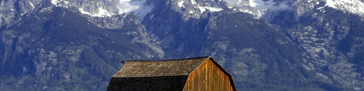
Rolling into Jackson, slow down and soak up the town’s western vibe. The iconic elk antler arches on the Town Square are a must-see photo stop, and the surrounding views hint at the wild country waiting just beyond. Jackson mixes history, outdoor culture, and big-mountain backdrops in a way that’s hard to beat.
More information regarding attractions, accommodation options, recommended restaurants, and campsites along the route is available in the "Itinerary" of this stage.
Jackson - United States - North America - Road Trip - Wikimedia Commons
❯
❮
9
Jackson
- Grand Teton N.P.
Distance 31 km
Driving time 1.1 h
Pace: slow
7.1 kWh
↓
View map
↓
Itinerary
[detailsContainer]
Leaving Jackson and rolling north toward Grand Teton N.P., you’ve got about 31 km and fewer than 1 hour of easy driving ahead, but it’s worth taking slowly. As you pull out of Jackson, glance back at the classic Western-style streets and the town’s wooden storefronts, a reminder of its frontier past. Keep an eye out for historical sites and old buildings around the center as you head toward the open road.
Soon the landscape opens up and the Teton Range starts to dominate your windshield. This stretch is all about the scenic road: wide valley views, winding asphalt, and those sharp peaks getting closer with every kilometer. The approach to Grand Teton N.P. is one long photo opportunity, so plan a couple of short stops to soak it in.
As you enter Grand Teton N.P., the mountains, forests, and lakes combine into one of the most picturesque landscapes you’ll see on this entire adventure. Some sections of the route may be closed seasonally, so it’s smart to check conditions before you roll.
More info about attractions, accommodation options, recommended restaurants, and campsites along the route is available in the "Itinerary" of this stage.
Grand Teton N.P. - United States - North America - Road Trip - www.nps.gov
❯
❮
10
Grand Teton N.P.
- Yellowstone N.P.
Distance 96 km
Driving time 3.3 h
Pace: slow
22.1 kWh
↓
View map
↓
Itinerary
[detailsContainer]
Rolling out of Grand Teton National Park, you’re in for a ridiculously scenic 96 km drive that’ll easily stretch into fewer than 4 unrushed hours once you factor in photo stops. The road threads between rugged peaks, mirror-like lakes, and wide valleys, so keep your eyes peeled for those picture-perfect roadside pullouts and views that just beg for a quick stop.
Take your time cruising through Grand Teton’s dramatic mountain backdrop – this is where you’ll want to pause often, soak in the skyline, and maybe catch some wildlife from the safety of your car. As you continue north toward Yellowstone National Park, the landscapes shift into steaming valleys, thick forests, and rivers that carve through the plateau, giving you that classic “I’m-on-a-legendary-road-trip” feeling.
Be aware that some sections of the route may be closed seasonally, especially when snow hits. In some sections the road is very winding, so go easy on the speed and enjoy the curves. In sections the road will be narrow, which means staying alert and giving extra space to oncoming traffic and slower vehicles.
More information regarding attractions, accommodation options, recommended restaurants, and campsites along the route is available in the "Itinerary" of this stage.
Yellowstone N.P. - United States - North America - Road Trip - Good Free Photos
Yellowstone N.P. - United States - North America - Road Trip - National Park Service
Yellowstone N.P. - United States - North America - Road Trip - commons.wikimedia.org
❯
❮
11
Yellowstone N.P.
- Livingstone
Distance 209 km
Driving time 4.0 h
Pace: modest
54.4 kWh
↓
View map
↓
Itinerary
[detailsContainer]
Starting in the heart of Yellowstone National Park, this 209 km drive to Livingston packs fewer than 4 hours of pure road‑trip joy. Roll out past steaming geyser basins, wide open valleys, and wildlife-rich meadows; the landscapes are so picturesque you’ll be tempted to pull over every few minutes. Some sections of the route may be closed seasonally, so it’s worth checking conditions before you set off.
Yellowstone is home to remarkable sites recognized as UNESCO Heritage, and as you leave the park and follow the river north toward Livingston, the scenery stays seriously scenic. Expect stretches where the road is very winding, hugging curves with constant views of mountains and water, and other sections where the road will be narrow, keeping you alert at the wheel while rewarding you with amazing panoramas.
Rolling into Livingston, you’ll find a laid-back Western town framed by dramatic peaks, perfect for a relaxed evening after a day behind the wheel. This drive connects seamlessly with other stages, making it feel like a natural piece of a bigger adventure.
More information regarding attractions, accommodation options, recommended restaurants, and campsites along the route is available in the "Itinerary" of this stage.
Livingstone - United States - North America - Road Trip - Wikimedia Commons
Livingstone - United States - North America - Road Trip - Wikipedia
❯
❮
12
Livingstone
- Glacier N.P.
Distance 542 km
Driving time 5.7 h
Pace: fast
162.6 kWh
↓
View map
↓
Itinerary
[detailsContainer]
Rolling out of Livingstone, United States, you’re in for a relaxed but stunning drive of about 542 km, with fewer than 6 hours behind the wheel. As you leave Livingstone, take a little time to wander its small-town streets, fuel up, and stock snacks before heading north. The road quickly turns into a scenic ride, with big-sky views and long stretches that beg for photo stops, so keep your eyes on both the landscape and the curves ahead.
Some sections of the route may be closed seasonally, so it’s smart to check conditions before you go, especially outside summer. Along the way, you’ll hit areas where the road is very winding and other parts where there will be steep ramps, so downshift early, keep your speed in check, and enjoy the twists instead of fighting them.
Rolling into Glacier N.P., the payoff is huge: glacier-carved valleys, rugged peaks, and lakes that look unreal from the roadside pullouts. Take the time to drive slowly, stop often, and soak in the atmosphere before parking up for hikes or viewpoint stops inside Glacier N.P.
More info on attractions, accommodation options, recommended restaurants, and campsites along the route is available in the "Itinerary" of this stage.
Glacier N.P. - United States - North America - Road Trip - Pikist
❯
❮
13
Glacier N.P.
- Calgary
Distance 369 km
Driving time 4.8 h
Pace: fast
110.6 kWh
↓
View map
↓
Itinerary
[detailsContainer]
Rolling out from Glacier N.P., you’ve got about 369 km and fewer than 5 hours of driving ahead, with plenty worth slowing down for.
Before you leave Glacier N.P., squeeze in a last look at its rugged peaks, glacial valleys, and mirror‑still lakes. This is the spot to enjoy classic mountain scenery and keep your camera handy for wildlife and dramatic skies over the Continental Divide.
On the way north, keep an eye out for stretches of scenic road where the mountains slowly give way to wide‑open prairie. You’ll pass through areas dotted with traces of Indigenous and settler history, so watch for roadside signs pointing to small historical sites just off the highway. The changing landscape here is part of the charm: rolling hills, big skies, and long views that make the drive itself a highlight.
As you close in on Calgary, the skyline rises out of the plains with the Rockies still visible in the distance. Calgary mixes modern city life with a strong western heritage, so it’s a fun place to park the car and explore neighborhoods, cultural spots, and riverside paths after a day on the road.
More details on attractions, accommodation, recommended restaurants, and campsites along this stage are available in the Itinerary.
Calgary - United States - North America - Road Trip - Needpix.com
Calgary - United States - North America - Road Trip - Flickr
Calgary - United States - North America - Road Trip - Wikipedia
❯
❮
14
Calgary
- Banff N.P.
Distance 182 km
Driving time 1.9 h
Pace: fast
54.6 kWh
↓
View map
↓
Itinerary
[detailsContainer]
Leaving Calgary, you roll out of a lively prairie city with the Rockies slowly growing on the horizon. Before you hit the highway for the 182 km drive (fewer than 2 hours), it’s worth stretching your legs at Calgary’s historic sites and viewpoints, then stocking up and filling the tank. Once on the road, keep an eye out for sweeping prairie landscapes giving way to rugged foothills; the transition is part of the magic, and the route itself feels like a long, unfolding scenic road.
As you approach Banff National Park, the mountains suddenly dominate everything. Jagged peaks, dense forests, and the wide Bow Valley make it hard to keep your eyes on the asphalt, so plan a few photo stops instead of trying to sightsee while driving. Some sections of the route may be closed seasonally, so it’s smart to check conditions before you set off, especially in shoulder seasons and winter storms.
Once in Banff National Park, you’ll find classic viewpoints, mountain trails, and lakes that reward every short detour from the main road. If you’re road-tripping with some flexibility, you’ll want to linger here. More information regarding attractions, accommodation options, recommended restaurants, and campsites along the route is available in the "Itinerary" of this stage.
Banff N.P. - United States - North America - Road Trip - Wikimedia Commons
Banff N.P. - United States - North America - Road Trip - Wikipedia
❯
❮
15
Banff N.P.
- Jasper N.P.
Distance 233 km
Driving time 3.3 h
Pace: fast
70.0 kWh
↓
View map
↓
Itinerary
[detailsContainer]
Rolling out of Banff National Park and cruising toward Jasper National Park, you’ve got about 233 km of seriously memorable driving ahead, with fewer than 4 hours behind the wheel if you go straight through. But you won’t want to rush it. The road between Banff and Jasper constantly pulls your eyes toward rugged peaks, sweeping valleys, and glacier‑carved scenery, so keep your camera handy and your speed in check.
As you drive, watch for spots that highlight the area’s history as a protected mountain landscape, and take your time at viewpoints where the mountains seem to fold into each other. Some sections of the route may be closed seasonally, so it’s worth checking conditions before you roll out, especially if you’re traveling early or late in the season. Along the way, you’ll be passing through areas that form part of UNESCO Heritage sites, which is a good reminder of just how special and well‑preserved this stretch of the Rockies really is.
This drive is perfect for road‑trippers who like to mix easy cruising with plenty of photo stops and short walks from the car. More details on attractions, accommodation options, recommended restaurants, and campsites along the route are available in the Itinerary of this stage.
Jasper N.P. - United States - North America - Road Trip - commons.wikimedia.org
❯
❮
16
Jasper N.P.
- Hope
Distance 648 km
Driving time 6.9 h
Pace: fast
194.5 kWh
↓
View map
↓
Itinerary
[detailsContainer]
Leaving Jasper National Park and rolling out on this 648 km stretch to Hope (under 7 hours of driving), you’ll have a day full of big views and easy stops. Take your time in Jasper N.P. first: wander around the townsite, check out the lakes and surrounding peaks, and soak up the mountain air before you hit the highway. Some sections of the route may be closed seasonally, so it’s worth checking conditions before you go.
Once you’re on the road, keep an eye out for historical sites tucked along the way and pull over at viewpoints whenever you can. Parts of this corridor pass near UNESCO Heritage sites, and you’ll feel that as the scenery flips from rugged alpine valleys to wide river plains and finally to thick, coastal forest. It’s a scenic road almost the whole way, with plenty of photo ops right from the driver’s seat.
Rolling into Hope, stretch your legs on riverside walks and explore the town’s laid-back streets framed by steep mountains. You’ll feel like you’ve properly crossed from the high Rockies into the lush West Coast.
More info about attractions, accommodation options, recommended restaurants, and campsites along the route is available in the Itinerary of this stage.
Hope - United States - North America - Road Trip - Wikimedia Commons
❯
❮
17
Hope
- Vancouver
Distance 150 km
Driving time 1.8 h
Pace: fast
44.9 kWh
↓
View map
↓
Itinerary
[detailsContainer]
Rolling out of Hope, you’ve got about 150 km and fewer than 2 hours of easy driving ahead before you hit Vancouver, and it’s a stretch you’ll want to take slow. In Hope, wander around the town center and keep an eye out for its wood carvings and historic buildings tucked between the mountains. As you drive on, the road threads through dramatic river valleys and forested slopes, with plenty of spots where the scenery opens up into postcard‑worthy views—perfect for quick stops and photos from safe pullouts. The closer you get to Vancouver, the more the landscape shifts from rugged mountains to coastal city vibes, but the views stay just as impressive, especially as you approach the skyline backed by the North Shore peaks. Once in Vancouver, you can park the car and stretch your legs exploring places like the waterfront, the beaches, and the parks that show off the city’s mix of ocean and mountain scenery, along with a few interesting historic corners if you wander a bit. More info about attractions, accommodation options, recommended restaurants, and campsites along this route is available in the Itinerary of this stage.
Vancouver - United States - North America - Road Trip - Tourism Vancouver
❯
❮
Vancouver
[detailsContainer]
Vancouver, Canada is an awesome grand finale for your Through Western USA and Canada Road Trip. Hugging the Pacific with mountains in the background, it’s one of those cities where you can hit the beach and the trail on the same day. If you’re flying in or out, the closest international airport is Vancouver International Airport (YVR), about 20–30 minutes from downtown depending on traffic.
For roadtrippers, downtown is compact and easy to navigate, with plenty of garages and some street parking if you’re patient. Start with Stanley Park – a huge urban park with the seawall looping around the edge. You can drive, but it’s worth parking and walking or biking the seawall for the skyline and mountain views. Don’t miss the totem poles near Brockton Point.
Next, roll over to Granville Island. It’s technically a peninsula, easy to reach by car, and packed with a public market, food stalls, breweries, and waterfront views. It’s a good spot to stretch your legs, grab coffee, and restock road snacks.
Stroll or cruise through Gastown, the city’s historic district, with brick buildings, independent shops, and tons of bars and restaurants. Parking is a bit tight, so expect pay lots. Nearby, Canada Place offers harbor and mountain views and is a quick stop for sunset photos.
If you want more scenery without ditching the car, drive up to the North Shore. Cross the Lions Gate Bridge to hit Capilano Suspension Bridge Park or the cheaper, more low-key Lynn Canyon for forest walks and canyon views. For epic city panoramas, drive up to Cypress Mountain viewpoints (especially at dusk).
As an ending point for the trip, Vancouver gives you big-city comforts, killer views, and tons of short drives that make the most of your final miles on the road.
Vancouver - United States - North America - Road Trip - vancouver.ca
❯
❮
Through Western USA and Canada Road Trip at a glance
-
Start:
San Francisco
-
End:
Vancouver
-
Distance:
5,511 km
-
Stay:
21 days
-
Getting there:
San Francisco International Airport (SFO),
Metropolitan Oakland International Airport (OAK)
-
When to drive:
June, July, August, September
-
More info:
More info you can find in the "Itinerary" section at each stage.
 -
-