New England's Indian Summer Road Trip Itinerary
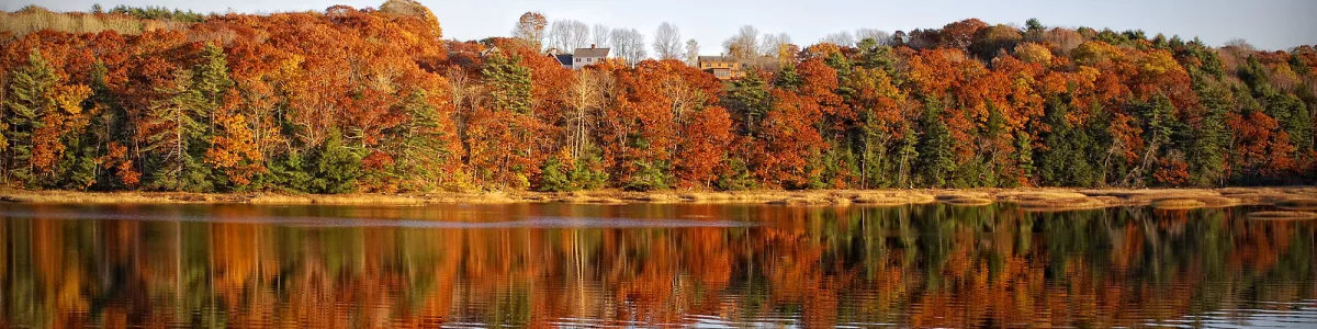
New England's Indian Summer Road Trip is a relaxed 14‑day loop of about 1964km that starts and ends in Boston, United States, and focuses on the fiery fall colors, coastal villages, and classic small towns that define this part of the country. The best time to drive it is from late September to mid‑October, when Indian Summer usually brings warm days, cool nights, and peak foliage across New England’s forests.
Leaving Boston, you head down toward Cape Cod, following the coastline until you reach Provincetown, perched at the very tip of the Cape. Provincetown, or “P‑town,” mixes fishing‑village roots with a lively arts scene. Stroll Commercial Street with its galleries, cafés, and independent shops, then walk out to Race Point Beach or Herring Cove Beach for big Atlantic views and lingering sunsets. The nearby Cape Cod National Seashore is a must‑see: long dune‑backed beaches, salt marshes, and historic lighthouses. Even a short hike along the dunes or a bike ride on the paved paths shows off how wild this stretch of coast still feels, especially with the contrast of golden marsh grass and red sumac leaves in fall.
From Cape Cod you swing west and then south into Connecticut, following a quieter stretch of New England shoreline until you roll into Mystic. This small town sits right on the Mystic River and is all about maritime history and low‑key charm. Mystic Seaport Museum is the big attraction here: an open‑air museum with historic ships, a recreated 19th‑century seafaring village, and chances to see traditional boatbuilding in action. Mystic Aquarium is another highlight if you’re into marine life, with beluga whales and interactive exhibits. In town, the drawbridge area is fun to wander, with old‑school ice cream stands, restaurants, and a waterfront atmosphere that feels especially cozy when the weather cools and the trees along the river flame orange and red.
Turning north, you cut up through rural backroads into the interior of New England, where the hills get higher and the foliage gets even more intense. Eventually you reach Lincoln in New Hampshire, a small mountain town that works as a perfect base for exploring the White Mountains. Lincoln sits at the western entrance to the Kancamagus Highway, one of the top fall‑color drives in the region. This scenic byway winds through dense forests, follows rivers, and opens up to overlooks with views of entire mountainsides washed in yellow, orange, and crimson. Short walks to Sabbaday Falls or Rocky Gorge are easy and rewarding. Nearby Franconia Notch State Park offers more must‑see spots: the Flume Gorge, an easy boardwalk trail through a narrow granite chasm, and the aerial tram at Cannon Mountain, which, in clear weather, gives you sweeping views over peaks and valleys filled with color. Lincoln itself has a laid‑back, ski‑town vibe, with breweries and diners that feel made for warming up after a day outside.
From the mountains you head northeast into Maine and up the coast to Camden, one of those classic New England harbor towns that look like they were designed for postcards. The town sits where the mountains meet the sea, which is a big part of its appeal. Camden Hills State Park is the must‑see here: a short drive or hike up to the top of Mount Battie gives you a stunning view over Camden Harbor, Penobscot Bay, and scattered islands, all framed by forested hills turning scarlet and gold. Back in town, the harbor is full of traditional schooners and sailboats; if the weather’s still mild, a short cruise on the bay is a great way to see the coastline and foliage from the water. Camden’s main streets are lined with old brick buildings, bookstores, and cafés, and the whole place has a calm, slightly old‑world feel that fits the slower pace of a road trip.
As you loop back south toward Boston, you pass through Salem, Massachusetts, which mixes pretty harbor scenery with some of New England’s most famous (and darker) history. Salem is best known for the 1692 witch trials, and that history is front and center in town. The Salem Witch Museum and several historic houses dive into the events and the broader context of colonial New England. Beyond the witch‑themed attractions, the Peabody Essex Museum stands out as a must‑see, with one of the oldest and most wide‑ranging art and maritime collections in the United States, including an entire historic Chinese house reassembled inside. Salem’s waterfront, part of the Salem Maritime National Historic Site, preserves wharves, warehouses, and a replica tall ship that highlight the town’s role in early American global trade. In fall, the tree‑lined streets and old clapboard houses look especially atmospheric, though October can be very busy with Halloween‑related events.
Eventually you return to Boston, closing the loop. If you have extra time at the beginning or end of the trip, it’s worth exploring neighborhoods like Beacon Hill and the North End, or walking part of the Freedom Trail to see key sites from the American Revolution. There are no UNESCO World Heritage sites directly on this specific route, but you do pass through or near several nationally significant historic districts and protected natural areas that offer a strong sense of early American history and New England’s coastal and mountain landscapes.
In terms of driving itself, road conditions along this route are generally good: paved highways and well‑maintained secondary roads. Still, there are a few things to watch out for. In peak foliage season, traffic can be heavy on scenic roads like the Kancamagus Highway, the Cape Cod roads, and the approaches to popular towns, so it’s smart to allow extra time and avoid driving tired. Weather can change quickly in the mountains around Lincoln, with fog, sudden showers, and, late in the season, the possibility of early frost or even a light dusting of snow on higher passes, which can make roads slick. On coastal stretches, strong rain and wind can reduce visibility. Wildlife, especially deer and sometimes moose in northern areas, is another risk at dawn and dusk, so keep your speed reasonable and scan the roadside. In small towns, watch for pedestrians, cyclists, and narrow streets. With normal caution, though, New England’s Indian Summer Road Trip is a straightforward, rewarding drive that lets you see the region at its most colorful and relaxed.
 14
number of days
14
number of days
 1,964 km
route length
1,964 km
route length
 fair
budget
fair
budget
 family
good for
family
good for
 on the right
traffic direction
on the right
traffic direction
 low
accident level
low
accident level
START
Boston
Distance 1,964 km
Driving time 27.0 h
Pace: fast
589.2 kWh
Airports
BOS
,
MHT
[detailsContainer]
Boston is a perfect starting point for the through New England in Indian Summer Road Trip. The city combines history, waterfront flair and a great location for a relaxed trip to the coast, forests and small New England towns.
Those arriving by plane usually land at Logan International Airport (IATA: BOS). The airport is close to downtown, is well connected and offers numerous large car rental companies directly on site (including Alamo, Avis, Budget, Enterprise, Hertz, National, Dollar, Thrifty). From the terminal, shuttle buses take you to the Rental Car Center - ideal for starting your road trip adventure straight after arrival.
In Boston itself, it is worth spending at least one day without a car and exploring on foot or by public transport:
Highlights in Boston - Freedom Trail - approx.
- Boston Common & Public Garden - green oases in the middle of the city, good for arriving and relieving jet lag.
- Quincy Market & Faneuil Hall - food stalls, stores and street artists, very touristy but atmospheric.
- North End - Boston's "Little Italy" with narrow streets and many restaurants, ideal for the evening.
- Boston Harborwalk - Walk along the water with a view of the skyline and harbour, great in good weather.
- Cambridge (Harvard/MIT) - accessible by subway, university campus atmosphere, bookshops, cafés.
After a day or two of sightseeing, you can pick up your rental car at the airport or in the city and set off on your "Through New England in Indian Summer" road trip from Boston.
1
Boston
- Provincetown
Distance 185 km
Driving time 2.3 h
Pace: fast
55.4 kWh
↓
View map
↓
Itinerary
[detailsContainer]
Rolling out of Boston, you’ll swap city vibes for coastal charm in no time. Before you hit the highway, wander around Boston’s historic streets and waterfront, soaking up the mix of brick-lined alleys, skyline views, and buzzing neighborhoods that make leaving a little bit hard.
Once you’re on the road, the 185 km drive to Provincetown takes under 3 hours, and it’s worth slowing down for the scenic stretches. Keep an eye out for those classic coastal views and shifting light over the water – this is the kind of route where you’ll want to pull over for a quick photo or two.
Rolling into Provincetown, the atmosphere flips from road-mode to full-on seaside escape. Colorful streets, quirky shops, and a laid-back harbor scene make it perfect for stretching your legs after the drive. Take your time wandering around, checking out the art-filled corners and lively waterfront – it’s a great place to park up, walk everywhere, and just let the day unfold.
For more detailed info on attractions, accommodation options, recommended restaurants, and campsites along this stage, check the "Itinerary" of this route.
 Provincetown - United States - North America - Road Trip - Wikimedia Commons
Provincetown - United States - North America - Road Trip - Wikimedia Commons
❯
❮
2
Provincetown
- Newport
Distance 226 km
Driving time 3.7 h
Pace: fast
67.8 kWh
↓
View map
↓
Itinerary
[detailsContainer]
Rolling out of Provincetown, you’ll leave the dunes and salty breeze in the rearview mirror as you cruise the 226 km toward Newport in under 4 hours. Before you hit the road, wander Provincetown’s lively streets, climb the Pilgrim Monument for awesome harbor views, and stroll Commercial Street for galleries and cafés that are perfect for a quick fuel-up.
Once you’re driving, take it easy and enjoy the scenic road: long stretches of coastal views, changing light over the water, and classic New England landscapes make this drive more than just a transfer. Keep an eye out for pull-offs where you can safely stop for photos and short breaks.
Rolling into Newport, you’ll swap wild dunes for grand elegance. Park up and walk the Cliff Walk, where ocean views crash against the rocky shore below historic mansions. If you have time, tour a mansion or two to really soak in the Gilded Age vibe, then end your day down by the harbor, watching the boats and grabbing a well-earned drink.
More details on attractions, accommodation options, recommended restaurants, and campsites along this stage are available in the "Itinerary" of this stage.
Newport - United States - North America - Road Trip - Wikimedia Commons
Newport - United States - North America - Road Trip - Wikimedia Commons
Newport - United States - North America - Road Trip - pxhere.com
❯
❮
3
Newport
- Mystic
Distance 78 km
Driving time 1.0 h
Pace: fast
23.4 kWh
↓
View map
↓
Itinerary
[detailsContainer]
Rolling out of Newport, you’ve got about 78 km and under an hour of easy driving ahead of you, so don’t rush it. Before hitting the road, wander around Newport’s harbor and soak up the mix of classic New England boats and salty sea air. If you’ve got time, a quick loop near the waterfront gives you that laid‑back coastal vibe that makes it hard to leave.
Once you’re on the move toward Mystic, keep an eye out for stretches where the road opens to glimpses of water and marshland—this is where you’ll want to ease off the gas a little and just enjoy the scenic road.
Rolling into Mystic, head straight for the Mystic Seaport Museum. It’s a fantastic stop for anyone who loves old ships, waterfront views, and that slow, nautical atmosphere that makes you feel like you’ve stepped back in time. Park up, stretch your legs, and wander the docks before you call it a day or move on.
For more details on attractions, accommodation options, recommended restaurants, and campsites along the route, check the "Itinerary" of this stage.
Mystic - United States - North America - Road Trip - Wikimedia Commons
❯
❮
4
Mystic
- Stockbridge
Distance 424 km
Driving time 6.0 h
Pace: fast
127.1 kWh
↓
View map
↓
Itinerary
[detailsContainer]
Rolling out of Mystic and aiming for Stockbridge, you’ve got about 424 km ahead of you and fewer than 6 hours behind the wheel, so it’s an easygoing day if you get an early start.
Before leaving Mystic, wander the historic waterfront at Mystic Seaport Museum, where classic ships, wooden docks, and the recreated 19th‑century village set a perfect coastal vibe. It’s a great spot to stretch your legs, grab a coffee, and soak up some maritime history before committing to the highway.
Once you’re on the road, keep an eye out for scenic stretches where the landscape opens up—rolling hills, forested sections, and glimpses of New England’s patchwork of small towns. This isn’t a day for rushing; it’s worth easing off the gas now and then to enjoy the changing views through your windshield.
As you roll into Stockbridge, slow down and drift into the classic New England charm around the Norman Rockwell Museum. The galleries, the surrounding grounds, and the calm countryside feel like driving straight into one of Rockwell’s paintings—especially nice after a few hundred kilometers on the road.
More details on attractions, accommodation, restaurants, and campsites along this stage are listed in the "Itinerary" of this route.
Stockbridge - United States - North America - Road Trip - Wikimedia Commons
❯
❮
5
Stockbridge
- Lincoln
Distance 159 km
Driving time 2.3 h
Pace: fast
47.7 kWh
↓
View map
↓
Itinerary
[detailsContainer]
Rolling out of Stockbridge, you’ve got about 159 km and under 3 hours of easy driving ahead, with plenty of chances to slow down and soak in the scenery.
Stockbridge is a great place to linger a bit before hitting the road. Wander its charming main streets, check out the classic New England architecture, and grab a coffee to go. If you’re into small-town vibes, this is exactly the kind of place that makes a road trip feel special.
Once you’re on the move, take it easy and keep an eye out for scenic stretches where the road twists through forest and rolling countryside. This is a drive where you’ll want to pull over now and then just to take in the views, especially as the landscape opens up on the way toward Lincoln.
Rolling into Lincoln, you’ll find a relaxed base with everything you need after a day behind the wheel. It’s the kind of town where you can park the car, stretch your legs, and enjoy a laid-back evening planning the next day’s drive.
More info on attractions, accommodation options, recommended restaurants, and campsites along the route is available in the Itinerary of this stage.
Lincoln - United States - North America - Road Trip - Pixabay
Lincoln - United States - North America - Road Trip - Wallpaperflare
❯
❮
6
Lincoln
- Acadia N.P.
Distance 410 km
Driving time 5.3 h
Pace: fast
123.1 kWh
↓
View map
↓
Itinerary
[detailsContainer]
Leaving Lincoln, you roll straight into mountain country, with the road quickly turning into a scenic ride framed by forested slopes and rocky peaks. Lincoln is a great spot to stretch your legs before driving, with plenty of chances to fuel up and grab last‑minute snacks. Once you’re on the way, the 410 km to Acadia N.P. pass in fewer than 6 hours, but it’s worth taking it slow whenever the views open up. In sections the road will be narrow, so keep an eye out for oncoming traffic and pullouts where you can safely stop for photos.
As you get closer to Acadia N.P., the landscape shifts from inland hills to rugged coastline. Road-trippers will love how the drive suddenly delivers ocean panoramas, granite headlands, and thick pine woods. Inside Acadia N.P., plan enough time to cruise the park roads, walk a short trail, or just park up and enjoy the sea breeze and crashing waves from scenic overlooks. Sunrise and sunset light make the rock and water glow, a perfect reward after a day behind the wheel.
More information regarding attractions, accommodation options, recommended restaurants, and campsites along the route is available in the "Itinerary" of this stage.
Acadia N.P. - United States - North America - Road Trip - www.nps.gov
❯
❮
7
Acadia N.P.
- Camden
Distance 129 km
Driving time 1.9 h
Pace: fast
38.6 kWh
↓
View map
↓
Itinerary
[detailsContainer]
Leaving Acadia National Park, you’ll kick off a gorgeous 129 km coastal drive that takes fewer than 2 hours, but you’ll want to go slower and enjoy every scenic curve. As you roll out of the park, make time for one last wander among its rocky shoreline and forested trails, or catch those sweeping ocean views from the park’s lookouts before you hit the road.
The drive itself is part of the fun, with long stretches where you’ll want to keep an eye out for scenic pullouts and photo stops along the coast. Stay alert for curves and changing light, especially if you’re driving early or late in the day—this road rewards an unhurried pace.
Camden welcomes you with a classic harbor-town vibe. Park the car and stroll the waterfront, watch the boats, and soak up the atmosphere. If you’re up for a short walk, head toward the viewpoints above town for postcard-perfect shots of the harbor and surrounding hills—a great way to end the day on the road.
More information about attractions, accommodation options, recommended restaurants, and campsites along the route is available in the Itinerary of this stage.
Camden - United States - North America - Road Trip - Wikimedia Commons
❯
❮
8
Camden
- Portland
Distance 131 km
Driving time 1.7 h
Pace: fast
39.2 kWh
↓
View map
↓
Itinerary
[detailsContainer]
Rolling out of Camden, you’ve got about 131 km and fewer than 2 hours of easy driving ahead, with a scenic road that keeps tempting you to pull over for photos.
Before you leave Camden, wander down to the harbor and soak up the classic coastal vibe. If you’ve got a bit of time, a quick stroll along the waterfront rewards you with salty air, bobbing boats, and that laid‑back small‑town feel that makes it hard to get back behind the wheel.
Once you reach Portland, park the car and switch to walking mode. Head straight for the Old Port, where cobblestone streets, brick warehouses, and the busy waterfront give you plenty to explore between coffee stops and photo ops. Don’t miss the Portland Head Light: the drive out is short and worth it, with waves crashing against rocky cliffs and one of the most photogenic lighthouses you’ll see on this tour.
Take your time, enjoy the coastal views from the driver’s seat, and treat this stretch as a relaxed link between two great stops.
More info about attractions, accommodation options, recommended restaurants, and campsites along the route is available in the "Itinerary" of this stage.
Portland - United States - North America - Road Trip - flickr.com
❯
❮
9
Portland
- Salem
Distance 186 km
Driving time 2.1 h
Pace: fast
55.9 kWh
↓
View map
↓
Itinerary
[detailsContainer]
Rolling out of Portland and pointing the car toward Salem, you’ve got about 186 km of easy driving ahead, under 3 hours if you don’t rush the stops. Before leaving Portland, wander around the waterfront and downtown, then duck into the city’s cozy coffee shops and food spots to fuel up. Portland’s creative vibe and laid-back streets make it a fun place to linger a bit before hitting the road.
Once you’re on the highway, keep an eye on the scenic road unfolding ahead of you. The changing views, stretches of greenery, and open sky make this drive perfect for windows-down, music-up cruising. Take it easy, watch the curves and traffic, and give yourself time to enjoy the landscape instead of just pushing for the destination.
Rolling into Salem, slow the pace again and explore the heart of the city. Its relaxed streets and local flavor are ideal for stretching your legs after the drive, grabbing a bite, and soaking in the small-city charm before you park up for the night or push on the next day.
More info about attractions, accommodation, recommended restaurants, and campsites along this route is available in the "Itinerary" of this stage.
Salem - United States - North America - Road Trip - commons.wikimedia.org
❯
❮
10
Salem
- Boston
Distance 37 km
Driving time 0.7 h
Pace: modest
9.6 kWh
↓
View map
↓
Itinerary
[detailsContainer]
Leaving Salem and cruising the short 37 km stretch to Boston (under 1 hour of easy driving) is a sweet city-to-city hop with loads to see on both ends.
In Salem, park up and wander around the atmospheric streets, dive into the town’s witch-trial history, and check out the harbor area before you roll out. It’s a compact place, so you can soak up a lot without rushing, then hit the road feeling you’ve really “done” Salem.
Boston is where this stage really explodes into big‑city energy. Once you arrive, stash the car and explore on foot: walk the historic streets, hang out by the waterfront, and get a feel for the neighborhoods and their different vibes. Boston’s perfect for evening strolls, grabbing a drink, or just people‑watching after a day behind the wheel.
This is a short drive, so it’s a great recovery stage: more time out of the car, less time staring at the highway.
For more details on attractions, accommodation options, recommended restaurants, and campsites along this route, check the Itinerary of this stage.
Boston - United States - North America - Road Trip - Wikimedia Commons
❯
❮
Boston
[detailsContainer]
Boston is the perfect grand finale for your “New England's Indian Summer Road Trip,” mixing colonial history, waterfront vibes, and a legit food scene in one compact, walkable city.
Start with the Freedom Trail, a 2.5‑mile red-brick path that links 16 historic spots like Boston Common, Faneuil Hall, Paul Revere’s House, and the Old North Church. You can walk it in a few hours, and it’s an easy way to get your history fix between drives.
For harbor views, head to the Seaport District and the Boston Harborwalk. It’s a great place to stretch your legs after long hours on the road, grab seafood, and watch the sunset over the water. If you’re into museums, the New England Aquarium is nearby, and the Institute of Contemporary Art sits right on the waterfront.
Don’t skip the North End, Boston’s Little Italy. Narrow streets, tasty pasta, and classic bakeries make it ideal for a slow evening stroll. It’s also right off the Freedom Trail, so you can roll it into the same outing.
For green space and skyline views, cruise over to the Charles River Esplanade. It’s a scenic spot for a walk, run, or just hanging out by the water, watching sailboats and rowers drift by.
If you’re mixing in some city driving, plan for tight streets and pricey parking. Many roadtrippers park at a hotel or garage and explore Boston on foot or by T (the subway). It’s faster and way less stressful than battling downtown traffic all day.
For anyone flying in or out, the closest international airport is Boston Logan International Airport (BOS), just across the harbor from downtown and easy to reach via tunnels, ferries, or rideshare.
New England's Indian Summer Road Trip at a glance
-
Start:
Boston
-
End:
Boston
-
Distance:
1,964 km
-
Stay:
14 days
-
Getting there:
Logan International Airport (BOS),
Manchester-Boston Regional Airport (MHT)
-
When to drive:
September, October
-
More info:
More info you can find in the "Itinerary" section at each stage.
 -
-