Shropshire Itinerary
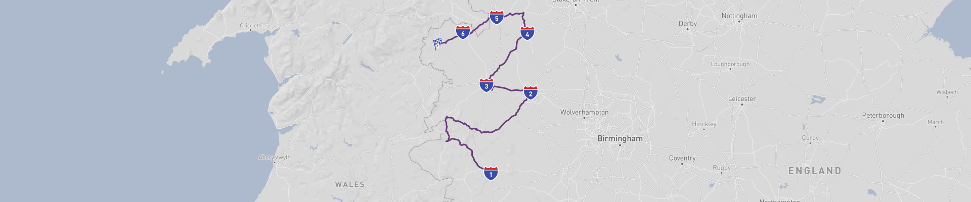
The Shropshire Road Trip is a relaxed, 2‑day drive of ca. 130mi that takes you from historic Ludlow up to the market town of Oswestry, winding through some of the prettiest corners of rural England. The best time of year to drive this route is late spring to early autumn (May–September), when daylight hours are long, the countryside is green, and you’ve got a good chance of decent weather for walks and viewpoints.
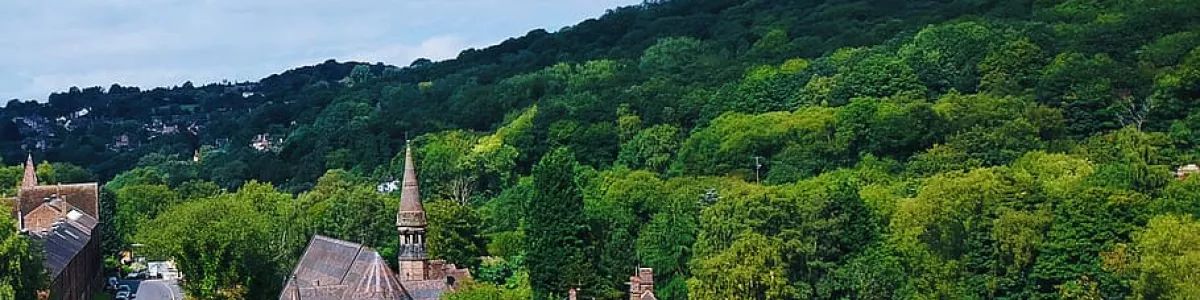
You kick off in Ludlow, a classic Shropshire market town known for its foodie scene and medieval streets. Ludlow Castle, perched above the River Teme, is the big draw here, with crumbling towers, views over rolling hills, and a real sense of history. The town centre is full of half‑timbered buildings, independent shops, and pubs where you can stock up on local produce or grab a slow lunch before hitting the road. From Ludlow you head north through gentle countryside, passing farmland, hedgerows, and small villages that give this area its laid‑back, old‑England feel.
One of the main stops on the way is Telford, a modern town that hides a serious historical heavyweight just outside its centre: Ironbridge Gorge. This area is a UNESCO World Heritage Site, often called the birthplace of the Industrial Revolution. The iconic Iron Bridge itself, the first major cast-iron bridge in the world, spans the River Severn and is a must‑see. Around the gorge you’ll find several museums – like Blists Hill Victorian Town, where you can walk through a recreated 19th‑century industrial community, and the Coalbrookdale Museum of Iron, which dives into the engineering that changed the world. It’s worth giving yourself a good half day here if you’re into history, engineering, or photography, as the scenery in the gorge is surprisingly green and dramatic.
Continuing north, the route takes you into Market Drayton, a traditional market town with a down‑to‑earth vibe. It’s known for its historic connection to gingerbread, so grabbing some from a local bakery is practically compulsory. The town centre has narrow streets, old inns, and a weekly market that keeps the place buzzing. Nearby, canals and gentle walking paths offer easy breaks from driving – the Shropshire Union Canal in particular gives you relaxed waterside strolls and the chance to spot narrowboats drifting past. Market Drayton is a good spot for a casual meal or a coffee stop before you carry on through the rural north of the county.
Further along, you pass through Ellesmere, a small town set among the “Meres” – a group of natural lakes that make this one of the most scenic parts of the trip. The main mere, Ellesmere itself, is just a short walk from the town centre and is perfect for a leg stretch. You can walk around the water, watch birdlife from viewpoints and hides, or simply sit with a takeaway coffee and enjoy the calm. The surrounding countryside is gently undulating and lush, and if you’ve got time, short detours lead to other meres and nature reserves that are great for birdwatching and quiet picnics.
The journey finishes in Oswestry, close to the Welsh border. Oswestry mixes English and Welsh influences and has a compact centre with independent shops, cafés, and traditional pubs. Just outside town you’ll find Old Oswestry Hillfort, one of the best‑preserved Iron Age hillforts in Britain, with walking paths that loop around the ramparts and deliver wide views across Shropshire and into Wales. The area around Oswestry is full of quiet lanes, stone farmhouses, and patchwork fields, so it’s a nice place to end the trip with a slow wander and a relaxed dinner before heading onward or staying overnight.
Road conditions along the Shropshire Road Trip are generally good, with a mix of A‑roads and smaller B‑roads. Still, there are a few things to keep in mind. Some rural stretches can be narrow, with sharp bends, high hedges, and limited visibility, so you’ll want to take it steady, especially in poor weather or at night. Tractors, cyclists, and horse riders are common, and you may encounter mud or standing water on the road after heavy rain. Around Telford and near larger towns you can hit peak‑time traffic, so planning your driving outside rush hours helps. In winter, icy patches and fog can be an issue on higher or more exposed sections, so if you’re not travelling in the recommended May–September window, check local conditions and allow extra time.
All in all, this 2‑day Shropshire Road Trip balances small‑town charm, countryside views, and serious history – from medieval Ludlow and the industrial power of UNESCO‑listed Ironbridge Gorge to the peaceful lakes near Ellesmere and the borderland character of Oswestry – making it an easygoing yet surprisingly varied drive across one of England’s quieter counties.
 2
number of days
2
number of days
 210 km
route length
210 km
route length
 high
budget
high
budget
 family
good for
family
good for
 on the left
traffic direction
on the left
traffic direction
 moderate
accident level
moderate
accident level
START
Ludlow
Distance 210 km
Driving time 4.5 h
Pace: modest
54.5 kWh
Airports
BHX
,
GLO
[detailsContainer]
Ludlow, in south Shropshire, is a brilliant starting point for the
Shropshire Road Trip. This small market town punches way above its weight when it comes to history, food and countryside views.
The star attraction is
Ludlow Castle, a massive Norman fortress overlooking the River Teme. You can wander the ruins, climb towers and get big views over the town and surrounding hills. Just outside is the broad
Castle Square, where regular markets sell local produce, crafts and street food – ideal for stocking the car before you hit the road.
Ludlow is also known for its foodie scene. The town has plenty of independent pubs, cafés and restaurants, many focused on local ingredients. If you’re into architecture, just walking the streets is a highlight: there’s a mix of black‑and‑white timber-framed houses, Georgian fronts and medieval lanes.
Other spots worth a stop:
- St Laurence’s Church – huge parish church with a tall tower you can climb for great views.
- Whitcliffe Common – short walk from town for classic postcard views back over the castle and rooftops.
- Ludlow Brewing Company – set in an old railway shed, with tours and tastings for beer fans.
For air travelers, the closest international airport is
Birmingham Airport (BHX), roughly 1.5–2 hours’ drive from Ludlow depending on traffic.
Birmingham Airport has plenty of on-site car rental options (major brands like Hertz, Avis, Enterprise, Europcar and others). Desks are in or near the arrivals area, and the car hire center is signposted from the terminal, so you can grab your vehicle and be on your way to Ludlow and the rest of Shropshire with minimal hassle.
1
Ludlow
- Telford
Distance 94 km
Driving time 2.4 h
Pace: modest
24.5 kWh
↓
View map
↓
Itinerary
[detailsContainer]
Rolling out of Ludlow, you leave a town steeped in history and head off on a relaxed 59mi drive that takes fewer than 3 hours, even with a few scenic pauses.
Before hitting the road, wander up to Ludlow Castle and soak up views over the countryside; it’s a perfect place to tune into the medieval feel of the town. Back in the streets, the historic timber-framed buildings set the mood for a day where you’ll want to keep an eye out for old churches, bridges, and traditional villages as you drive. Some UNESCO Heritage sites are along the route, so it’s worth planning a couple of short stops to stretch your legs and explore.
Out on the road, expect some very winding sections and, in places, the road will be narrow, so take it easy and enjoy the changing scenery rather than rushing. The approach to Telford brings you towards impressive industrial heritage and more chances to dive into Britain’s past once you park up.
For more information regarding attractions, accommodation options, recommended restaurants, and campsites along the route, check the "Itinerary" of this stage.
 Telford - England - Europe - Scenic Drive - Max Pixel
❯
❮
2
Telford
- Shrewsbury
Distance 26 km
Driving time 0.4 h
Pace: fast
7.8 kWh
↓
View map
↓
Itinerary
[detailsContainer]
Rolling out of Telford, you’ve got a relaxed 16mi drive ahead of you, under 1 hour behind the wheel, so there’s no rush. Before you hit the road, wander around the Ironbridge Gorge, where old industrial buildings, wooded slopes, and the famous iron bridge itself sit right above the river. It’s a great place to stretch your legs, grab a coffee, and soak up some history before the next stint of driving.
Once you’re back on the road toward Shrewsbury, take it easy and enjoy the more scenic stretches; there are some lovely open views where it’s worth easing off the gas and just cruising. Rolling into Shrewsbury, aim for Shrewsbury Castle first, with its red sandstone walls and views over the town, then wander through the narrow streets to Shrewsbury Abbey, which adds a quieter, more reflective stop to your day.
It’s a compact stage, but packed with character at both ends, making it perfect for a chilled driving day with plenty of time to explore on foot.
More details on attractions, accommodation, recommended restaurants, and campsites along this route are available in the "Itinerary" of this stage.
Shrewsbury - England - Europe - Scenic Drive - www.geograph.org.uk
❯
❮
3
Shrewsbury
- Market Drayton
Distance 34 km
Driving time 0.6 h
Pace: modest
8.7 kWh
↓
View map
↓
Itinerary
[detailsContainer]
Leaving Shrewsbury, you’ve got about 21mi and less than an hour’s drive of easy exploring ahead. Before you roll out, wander around Shrewsbury Castle and its grounds; it’s a solid spot to stretch your legs and grab those classic red-sandstone photos. Shrewsbury Abbey is also worth a quick visit, especially if you like a bit of quiet history before hitting the road.
Once you’re driving, keep an eye out for historic buildings and church towers peeking over the trees, and enjoy the scenic road as it winds through the countryside. In some sections the road is very winding, and in sections the road will be narrow, so take it steady and enjoy the views rather than rushing. This stretch feels made for unhurried driving and quick photo stops from lay-bys.
Rolling into Market Drayton, park up and head towards St Mary’s Church, a lovely landmark to wander around and a good reference point for exploring the town on foot. It’s the kind of place where you can grab a coffee, stroll a bit, and soak up the local vibe after the drive.
More info on attractions, accommodation options, recommended restaurants, and campsites along the route is available in the "Itinerary" of this stage.
Market Drayton - England - Europe - Scenic Drive
❯
❮
4
Market Drayton
- Whitchurch
Distance 24 km
Driving time 0.5 h
Pace: modest
6.3 kWh
↓
View map
↓
Itinerary
[detailsContainer]
Rolling out of Market Drayton, you’ve got about 15mi and under an hour of easy driving ahead, perfect for a relaxed day on the road.
Before you leave, wander around Market Drayton’s traditional centre, then make time for a visit to the local breweries and cosy pubs that give the town its character. It’s a great place to stock up on local treats for the rest of your journey and stretch your legs with a slow stroll past old brick buildings and tucked‑away corners.
Once you’re on the move, enjoy the scenic road between the two towns. In some sections the road is very winding, and in sections the road will be narrow, so keep your speed down and just enjoy the countryside views slipping by your windows.
Rolling into Whitchurch, park up and explore its historic streets on foot. The town has an easygoing feel, with traditional architecture, independent shops, and welcoming spots to grab a drink or a bite after the drive. It’s the kind of place where you’ll want to linger a little before moving on.
More information regarding attractions, accommodation options, recommended restaurants, and campsites along the route is available in the "Itinerary" of this stage.
Whitchurch - England - Europe - Scenic Drive
❯
❮
5
Whitchurch
- Ellesmere
Distance 18 km
Driving time 0.4 h
Pace: modest
4.8 kWh
↓
View map
↓
Itinerary
[detailsContainer]
Starting in Whitchurch, you’ll roll out of town with under 11 miles and fewer than 1 hour of easy driving ahead of you, but don’t rush it.
Before hitting the road, wander Whitchurch’s streets to soak up its classic English market-town feel. It’s a great place to grab road snacks, stretch your legs, and check your route before you cruise on. Once you’re driving, keep an eye on the scenery – this stretch has a gentle, rural charm, and in some sections the road is very winding, so ease off the speed and enjoy the views as they open up between hedgerows and fields.
Rolling into Ellesmere, aim straight for The Mere. This beautiful lake is perfect for a relaxed walk, a quick picnic, or just sitting by the water to unwind after the drive. It’s the ideal spot to park up, breathe, and enjoy the peaceful vibe before you move on to your next destination.
More information regarding attractions, accommodation options, recommended restaurants, and campsites along the route is available in the Itinerary of this stage.
Ellesmere - England - Europe - Scenic Drive
❯
❮
6
Ellesmere
- Oswestry
Distance 13 km
Driving time 0.3 h
Pace: modest
3.4 kWh
↓
View map
↓
Itinerary
[detailsContainer]
Leaving Ellesmere, you’ve got less than 8mi and under an hour of easy driving ahead, but don’t rush it. Before you roll out, wander down to The Mere, the big, peaceful lake that gives the town its character. It’s a great spot to stretch your legs, enjoy the water views, and grab a breather before getting back behind the wheel.
Once you’re on the road, take it slow and enjoy the scenic road between hedgerows and open fields. In some sections the road is very winding, so keep an eye on the bends and be ready for the occasional tight corner. It’s a short hop, but it feels pleasantly rural and relaxed, perfect for a gentle cruise rather than a sprint.
Rolling into Oswestry, park up and head for the historic town centre. The narrow streets, old buildings, and independent shops make it a fun place to wander on foot after driving. It’s an ideal end point for this stage, with enough character to make you want to linger a bit longer.
More information regarding attractions, accommodation options, recommended restaurants, and campsites along the route is available in the Itinerary of this stage.
Oswestry - England - Europe - Scenic Drive
❯
❮
Oswestry
[detailsContainer]
Oswestry is a great final stop for your “Shropshire Road Trip,” especially if you’re into history, views, and easy drives between sights.
Start with Old Oswestry Hillfort, one of the best‑preserved Iron Age hillforts in Britain. It’s an easy walk from town and the ramparts give you wide countryside views that feel made for sunset photos from the car park or nearby paths.
In town, wander the compact center with its mix of half‑timbered buildings, narrow lanes, and indie shops. The Church of St Oswald is worth a quick look, and the surrounding streets are perfect for stretching your legs after a day behind the wheel. Stop into a local pub or café for a casual bite; parking is usually straightforward in or just off the center.
For something different, head to the Cambrian Heritage Railways. When trains are running, it’s a fun break from driving, and even off‑days are cool for photos and a short walk along the line. If you’ve got time, take the short drive out to the borderlands: places like the Montgomery Canal and small Welsh villages are just a few miles away and make for scenic side loops before you wrap up the trip in Oswestry.
Road access is easy: Oswestry sits close to the A5, linking you north toward Wrexham and south toward Shrewsbury. That makes it a handy base for overnight stops, with plenty of B&Bs and small hotels that have on‑site or nearby parking.
For travelers flying in, the closest major international airport is Liverpool John Lennon Airport (LPL), roughly 1.5 hours’ drive depending on traffic. Manchester Airport (MAN) is another solid option with more long‑haul connections and is about a similar drive, so you can start or end your Shropshire Road Trip there and roll straight into Oswestry.
Shropshire at a glance
-
Start:
Ludlow
-
End:
Oswestry
-
Distance:
210 km
-
Stay:
2 days
-
Getting there:
Birmingham International Airport (BHX),
Gloucestershire Airport (GLO)
-
When to drive:
May, June, July, August, September, October
-
More info:
More info you can find in the "Itinerary" section at each stage.

 -
-