Tierras del Sil Itinerary
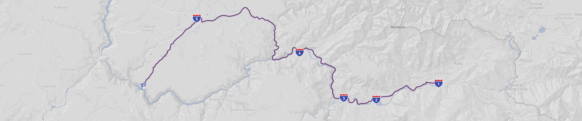
Tierras del Sil Scenic Drive is a roughly 86km road trip in north‑west Spain that links the wine town of O Barco de Valdeorras with the dramatic gorge area of Cañón del Sil. Plan about 2 days for the drive so you can actually stop, walk a bit and enjoy the views instead of just rushing from A to B.
You start in O Barco de Valdeorras, in the Valdeorras valley. This is Godello and Mencía country, so it’s worth visiting a local winery or two to taste the DO Valdeorras wines and see the terraced vineyards that cling to the slopes. The town has a relaxed feel, some riverside walks along the Sil, and a few old churches and traditional stone houses that give you a nice intro to the region. Stock up on local wine and cured meats here; you’ll want them for picnic stops later on.
Leaving O Barco, the road follows the Sil valley and soon you reach A Rúa. This small town sits right by the river and the artificial lake of San Martiño, which creates a calm, almost alpine panorama of water and hills. It’s a good place for a coffee break at the waterfront, a short stroll over the bridge, or even a quick swim or paddle in summer if conditions allow. Nearby you’ll find remains of Roman mining activity and old wine cellars carved into the rock, hinting at how long people have been working these hills. If you’re into walking, look for short trails around the reservoir and viewpoints over the vineyards.
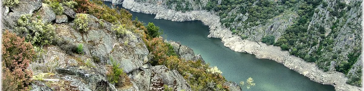
Continuing west, the valley starts to close in and the landscape turns wilder as you approach the territory of Ribas de Sil. This stretch is where the trip really earns the word “scenic”: winding roads, dense chestnut forests, steep slopes and constant glimpses of the Sil far below. Ribas de Sil is spread out in several small villages, many with traditional slate‑roofed houses and tiny Romanesque chapels. From here you can access some of the classic “miradores” (viewpoints) over the gorge. Short detours bring you to balconies hanging over the river, where you see the cliffs dropping almost vertically to the water and, on the opposite side, terraced vineyards of the Ribeira Sacra DO carved into impossible angles. This whole Ribeira Sacra area is on Spain’s Tentative List for UNESCO World Heritage thanks to its mix of early medieval monasteries, ancient vineyards and dramatic landscape, so it has a strong “future UNESCO” feel even if it’s not yet officially inscribed.
As you close in on Cañón del Sil, the road begins to climb and twist more aggressively, but the reward is that you arrive at one of the most impressive river gorges in the country. The final area around Cañón del Sil is all about viewpoints and monasteries. Must‑see spots include several miradores signposted from the main road, where you get those postcard views of the Sil cutting a deep, narrow trench between granite walls. If you have time, take one of the catamaran or small‑boat trips on the river to see the canyon from below, looking up at the terraces and cliffs. On the slopes you’ll find centuries‑old monasteries (like Santo Estevo or Santa Cristina de Ribas de Sil, reachable by short detours) hidden among the trees; many were founded in the early Middle Ages and are surrounded by ancient chestnut groves and terraced vineyards. The mix of monastic history, wine culture and raw nature is what makes this end of the trip feel special and a bit timeless.
Best time of year to drive Tierras del Sil Scenic Drive is from late spring to early autumn. May and June give you lush green slopes, mild temperatures and fewer crowds. September and October are especially beautiful: it’s harvest season in the vineyards, the light is softer, and the forests start turning golden and red, which makes the canyon views even more dramatic. High summer (July–August) can be hot, but it’s great for river activities and long evenings outdoors, just be ready for warmer temperatures and slightly busier roads near the main viewpoints.
Road conditions are generally good asphalt, but this is mountain and canyon territory, so expect narrow sections, sharp bends and occasional steep drop‑offs without much shoulder. In wet weather, some stretches can get slippery, and in winter you may encounter fog, ice or fallen rocks after heavy rain. Drive slowly, especially at dusk and dawn, because wildlife (like wild boar or deer) can cross unexpectedly, and watch out for cyclists and hikers on the smaller roads. Make sure your brakes are in good shape before you go, use low gear on long descents, and fuel up in the bigger towns (like O Barco or A Rúa), as services become sparse once you’re deep in the canyon area.
With two days to play with, you can combine short hikes, winery visits, monastery stops and river viewpoints into a relaxed loop, turning the Tierras del Sil Scenic Drive into a compact but memorable deep‑dive into one of Spain’s most underrated landscapes.
 2
number of days
2
number of days
 86 km
route length
86 km
route length
 fair
budget
fair
budget
 family
good for
family
good for
 on the right
traffic direction
on the right
traffic direction
 moderate
accident level
moderate
accident level
START
O Barco de Valdeorras
Distance 86 km
Driving time 1.5 h
Pace: modest
22.4 kWh
Airports
BGC
[detailsContainer]
O Barco de Valdeorras is a small riverside town in Galicia, northwest Spain, and a great base for kicking off the Tierras del Sil Scenic Drive. It sits in the Sil River valley, surrounded by vineyards and low mountains, so it’s a relaxed place to stock up, stretch your legs, and plan your route.
The town center is compact and walkable. Wander along the Sil River promenade for views of the bridges and hills, and check out the old quarter around Plaza Mayor for bars and cafés. If you like churches and local history, pop into the Iglesia de San Mauro and the Iglesia de Santa Rita. They’re modest but give you a feel for traditional Galician architecture and religious art.
Wine fans shouldn’t miss the local Godello and Mencía wines. This is Valdeorras DO country, so you’ll find plenty of wineries in the area offering tastings; it’s worth planning a stop at a nearby bodega before or after your drive.
For a quick nature fix close to town, look for short trails along the Sil and viewpoints over the valley. They’re ideal if you want a preview of the landscapes you’ll see along the Tierras del Sil Scenic Drive.
If you’re flying in, the closest international airport is Vigo Airport (VGO), roughly 2 hours away by road. From Vigo, you can rent a car directly at the airport; major rental companies like Avis, Europcar, Hertz, and Enterprise typically operate there, plus several local outfits. Booking ahead is smart, especially in summer, to make sure you get the car size you want for your road trip.
1
O Barco de Valdeorras
- A Rua
Distance 13 km
Driving time 0.3 h
Pace: modest
3.5 kWh
↓
View map
↓
Itinerary
[detailsContainer]
Leaving O Barco de Valdeorras, you’ve got about 13 km and under an hour of easy driving ahead, but don’t rush it. Roll slowly out of town and wander through its center on foot first: check out the riverside area and the relaxed local vibe before you hit the road again. Once you’re driving, keep your eyes on the scenery; in some sections the road is very winding and in sections the road will be narrow, so enjoy the views but stay focused behind the wheel.
The short hop to A Rua is all about soaking up the surroundings. When you arrive, park up and stretch your legs around town, taking time to explore its streets and riverside corners. It’s a laid-back place that feels made for a slow stroll after being in the car, and a good spot to refuel yourself before moving on.
This little link between O Barco de Valdeorras and A Rua might be quick, but it’s a nice breather in your wider journey, with enough charm to justify lingering in both towns.
More details on attractions, accommodation options, recommended restaurants, and campsites along the route are available in the "Itinerary" of this stage.
 A Rua - Spain - Europe - Scenic Drive
❯
❮
2
A Rua
- Montefurado
Distance 8 km
Driving time 0.1 h
Pace: fast
2.5 kWh
↓
View map
↓
Itinerary
[detailsContainer]
Starting in A Rua, you’ve got a short 8 km hop ahead of you, less than an hour behind the wheel, but it’s a stretch worth taking slowly. Before you roll out, wander through A Rua’s quiet streets and enjoy its relaxed vibe; it’s a good place to stretch your legs, grab a coffee, and get into road-trip mode. Once you hit the road towards Montefurado, keep your eyes on the scenery as well as on the tarmac – this is a scenic road with river views and green slopes that make the drive feel special, but in some sections the road is very winding, so take it easy and enjoy the curves.
As you approach Montefurado, the landscape tightens and you’ll notice how the village seems to grow out of the surrounding hills. Montefurado is all about atmosphere: old stone houses, narrow lanes, and a sense that time moves a bit slower here. Park up and explore on foot; it’s the kind of place where a simple stroll becomes a highlight of the day, especially if you like discovering quiet corners and viewpoints.
More information regarding attractions, accommodation options, recommended restaurants, and campsites along the route is available in the Itinerary of this stage.
Montefurado - Spain - Europe - Scenic Drive
❯
❮
3
Montefurado
- Ribas de Sil
Distance 16 km
Driving time 0.2 h
Pace: fast
4.9 kWh
↓
View map
↓
Itinerary
[detailsContainer]
Leaving Montefurado, you’ve got about 16 km and under an hour of easy driving ahead, but don’t rush it. As you roll out of the village, keep an eye on the scenic road that winds above the Sil River, with rock walls on one side and dramatic drops and views on the other. In some sections the road is very winding, so it pays to slow down, enjoy the landscape, and stop only where it’s clearly safe.
Montefurado itself is worth a short wander before you leave, especially around the riverside area where you can see how the village hugs the curves of the Sil and feels almost carved into the hillside.
Ribas de Sil welcomes you at the end of the stage with its quiet riverside charm. Park up and stretch your legs along the river, then explore the compact village streets where everyday life still moves at a relaxed pace. It’s a nice place to sit outside, watch the light shift on the water, and plan your next driving day.
More information regarding attractions, accommodation options, recommended restaurants, and campsites along the route is available in the "Itinerary" of this stage.
Ribas de Sil - Spain - Europe - Scenic Drive
❯
❮
4
Ribas de Sil
- Monforte de Lemos
Distance 31 km
Driving time 0.4 h
Pace: fast
9.4 kWh
↓
View map
↓
Itinerary
[detailsContainer]
Starting in Ribas de Sil, you roll out along the river and quickly feel you’re in real canyon country. The road is packed with curves and viewpoints, so take it easy and enjoy the scenery; in some sections the road is very winding and you’ll want to keep your eyes on both the bends and the dramatic slopes dropping toward the water.
The 31 km to Monforte de Lemos take fewer than 1 hours, but it’s worth stretching it out with a couple of stops. As you get closer to Monforte de Lemos, the route becomes a great mix of scenic road and hints of history on the horizon, with the town’s silhouette slowly appearing ahead.
Rolling into Monforte de Lemos, park up and wander its historic core. This is a place to swap the steering wheel for a stroll through narrow streets and soak up the atmosphere of old stone buildings and timeless squares. It’s a relaxed, compact town, perfect for a late-afternoon walk after a day behind the wheel.
More info on attractions, accommodation options, recommended restaurants, and campsites along the route is available in the Itinerary of this stage.
Monforte de Lemos - Spain - Europe - Scenic Drive - commons.wikimedia.org
❯
❮
5
Monforte de Lemos
- Canon del Sil
Distance 17 km
Driving time 0.4 h
Pace: slow
3.9 kWh
↓
View map
↓
Itinerary
[detailsContainer]
Leaving Monforte de Lemos, you’ve got about 17 km and under an hour of driving ahead, plenty of time to soak in the scenery. Before you roll out, wander around Monforte de Lemos’ historic center and castle area, where stone streets and old walls set a great mood for the day. It’s a good place for a quick coffee and to fuel up both car and driver.
Once you hit the road towards Cañón del Sil, take it slow and enjoy the views: this is a scenic road with stretches that twist through vineyards and forests. In some sections the road is very winding, so keep your speed under control and be ready for sharp bends. In sections the road will be narrow, which means you’ll want to stay focused, especially when meeting oncoming traffic.
As you arrive at Cañón del Sil, park up and head for the viewpoints over the gorge. The dramatic cliffs dropping to the Sil River are the real reward of this stage, especially around sunset. It’s a perfect spot to stretch your legs, snap photos, and just listen to the silence of the canyon.
More information regarding attractions, accommodation options, recommended restaurants, and campsites along the route is available in the "Itinerary" of this stage.
Canon del Sil - Spain - Europe - Scenic Drive
❯
❮
Canon del Sil
[detailsContainer]
Canon del Sil, tucked into Galicia’s Ribeira Sacra region, makes an awesome finale for the Tierras del Sil Scenic Drive. Carved by the Sil River into dramatic gorges, this area is all about tight, winding roads, killer viewpoints, and ancient vineyards clinging to crazy-steep slopes.
Rolling in by car, your first must-see is the Sil Canyon viewpoints (miradores). Don’t miss spots like Mirador de Cabezoás or Mirador de Vilouxe: short walks from the parking areas, huge payoff in cliff-and-river panoramas. Go early or near sunset for easier parking and softer light for photos.
Next up, hit the vineyard terraces. This is “heroic viticulture” country, with tiny plots and stair-like terraces. Look for small local bodegas along the river road; many offer tastings of Mencía reds and Godello whites, plus quick tours of their hillside vines. Access roads can be narrow and twisty, so take it slow and watch for tractors and hikers.
Down at river level, a Sil River catamaran cruise is pretty much a must. Boats leave from several small docks (like Santo Estevo or Doade area); reserve ahead if you’re traveling in peak season. Seeing the canyon walls from the water gives a totally different feel than from the road.
Culture-wise, don’t skip the Ribeira Sacra monasteries, especially Santo Estevo or Santa Cristina. They’re usually reached via scenic backroads with plenty of pullouts for photos and short hikes.
If you’re flying in, the closest practical international airport is Santiago de Compostela Airport (SCQ), about a couple of hours’ drive away depending on your exact base in the canyon. From there, rent a car—Canon del Sil and the whole Tierras del Sil Scenic Drive are made for slow, flexible roadtripping, with tons of side roads, viewpoints, and tiny villages to explore along the way.
Tierras del Sil at a glance
-
Start:
O Barco de Valdeorras
-
End:
Canon del Sil
-
Distance:
86 km
-
Stay:
2 days
-
Getting there:
Bragança Airport (BGC)
-
When to drive:
May, June, July, August, September, October
-
More info:
More info you can find in the "Itinerary" section at each stage.
 -
-