Ebbetts Pass Panoramic Road Itinerary
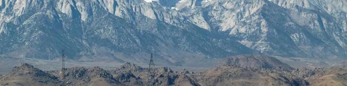
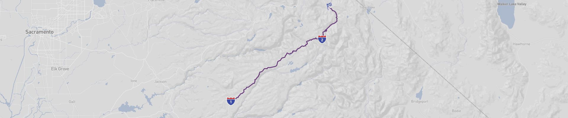
The Ebbetts Pass Panoramic Road trip is an amazing journey through some of the most spectacular and picturesque landscapes in California. Starting in Arnold, the route leads through the small towns of Avery, Spicer Reservoir, and Hermit Valley before reaching Ebbetts Pass, a stunning alpine meadow at an elevation of 8,715 feet. From here, the road winds down to Markleeville, the final destination of this 97 km (60 mile) trip.
The best time of year to take this road trip is in the summer, when the days are warm and the views of the Sierra Nevada mountain range are clear and breathtaking. However, the road is often closed due to snow during winter months, so be sure to check the road conditions before you set off.
The route is mostly curvy and can be challenging, but the experience and memories you'll take away from this trip are well worth it. It's suitable for all drivers and can be managed on a moderate budget, making it a great choice for a road trip.
 1
number of days
1
number of days
 97 km
route length
97 km
route length
 fair
budget
fair
budget
 tourist
good for
tourist
good for
 on the right
traffic direction
on the right
traffic direction
 fair
accident level
fair
accident level
START
Arnold
Distance 97 km
Driving time 1.6 h
Pace: modest
25.2 kWh
Airports
SMF
[detailsContainer]
Arnold, in Calaveras County, California, is the ideal starting point for the Ebbetts Pass Panoramic Road. This picturesque town is located at the base of the Sierra Nevada Mountains, providing a stunning vista to those who visit. Arnold is teeming with interesting sights and activities to experience. From exploring the area’s history in the Calaveras Big Trees State Park, to mountain biking and camping in the nearby Stanislaus National Forest, there is something for everyone.
Those traveling by air should fly into the Stockton Metropolitan Airport (SCK), which is the closest international airport to Arnold. From the airport, car rentals are available, making it easy to start your road trip along the Ebbetts Pass Panoramic Road. The road trip will take you on a picturesque journey through the Sierra Nevada Mountains, providing spectacular views with plenty of opportunities to explore the surrounding area.
Visitors to Arnold will find plenty to do and will quickly fall in love with the beautiful scenery. Whether you’re looking for outdoor adventure, or just a relaxing getaway, Arnold is the perfect starting point for your road trip.
1
Arnold
- Ebbetts Pass
Distance 69 km
Driving time 1.1 h
Pace: fast
20.8 kWh
↓
View map
↓
Itinerary
[detailsContainer]
Embark on the journey from Arnold, United States and explore the wonders of Ebbetts Pass. This 43mi drive will take you less than 2 hours and you can enjoy a scenic road with some sections that may be closed seasonally.
Take a break in Bear Valley and experience the beauty of the alpine meadows, the lush forests, and the majestic peaks. You can also explore the nearby Calaveras Big Trees State Park, a beautiful grove of ancient sequoia trees.
Continue your journey to Lake Alpine, a beautiful mountain lake surrounded by majestic peaks and lush forests. Here you can enjoy a variety of outdoor activities, such as fishing, boating, and swimming.
Finally, you will arrive at Ebbetts Pass, a stunning mountain pass that offers spectacular views of the Sierra Nevada Mountains. Here you can explore the nearby Stanislaus National Forest, a vast wilderness area with hiking trails, rivers, and lakes.
For more information regarding attractions, accommodation options, recommended restaurants, and campsites along the route, please consult the "Itinerary" of this stage. Enjoy the journey!
 Ebbetts Pass - United States - North America - Scenic Drive - Wikimedia Commons
❯
❮
2
Ebbetts Pass
- Markleeville
Distance 27 km
Driving time 0.5 h
Pace: modest
7.1 kWh
↓
View map
↓
Itinerary
[detailsContainer]
Embark on an exciting road trip from Ebbetts Pass to Markleeville, a 17mi journey that will take less than an hour. As you drive along this scenic route, you'll be surrounded by the beauty of the Sierra Nevada Mountains. Be mindful that some sections of the road may be closed seasonally, and in some sections the road is very winding, so pay attention to the road signs.
In Ebbetts Pass, be sure to take a stroll along the Stanislaus River, or take a break at the Ebbetts Pass Scenic Byway. As you make your way to Markleeville, take a moment to admire the beauty of the Carson-Iceberg Wilderness. Once in Markleeville, explore the historic Alpine County Courthouse, or take a drive along the Markleeville Creek.
This is just one stage of a much longer road trip, and more information regarding attractions, accommodation options, recommended restaurants, and campsites along the route is available in the "Itinerary" of this stage. So, get your car ready, and get ready for an unforgettable journey from Ebbetts Pass to Markleeville!
Markleeville - United States - North America - Scenic Drive - commons.wikimedia.org
❯
❮
Markleeville
[detailsContainer]
Markleeville is a charming mountain town located in Alpine County, California. It is the perfect ending point for the Ebbetts Pass Panoramic Road, a picturesque drive through the Sierra Nevada mountains. On the way, you will pass through several small towns, breathtaking alpine meadows, and lush forests.
Once you reach Markleeville, you will be able to explore its unique natural attractions. Visit the Grover Hot Springs State Park for its stunning views and healing hot springs. You can also take in the beauty of the Carson Pass Area, a popular destination for hiking, fishing, and camping. For a more historical experience, visit the Markleeville Historic Park, which features an old courthouse, jail, and museum.
Markleeville is also home to several restaurants, shops, and wineries. Enjoy a delicious meal at the Markleeville Grill, or pick up some local produce at the Markleeville Farmers Market. For those looking to relax, there are several spas and massage therapists located in town.
The closest international airport to Markleeville is Reno-Tahoe International Airport (RNO). From there, you can rent a car and drive to the picturesque town in about two and a half hours.
Markleeville is the perfect ending point for an unforgettable road trip. With its natural beauty, historical attractions, and delicious restaurants, you are sure to have an amazing time in this charming mountain town.
Ebbetts Pass Panoramic Road at a glance
-
Start:
Arnold
-
End:
Markleeville
-
Distance:
97 km
-
Stay:
1 day
-
Getting there:
Sacramento International Airport (SMF)
-
When to drive:
June, July, August, September, October
-
More info:
More info you can find in the "Itinerary" section at each stage.
Before you set off
Embark on the Ebbetts Pass Scenic Byway, a captivating journey traversing California's Sierra Nevada mountain range. Starting in Arnold, the 97 km (60 mile) route meanders to Markleeville, presenting an array of breathtaking vistas including lush alpine meadows, rugged peaks, and the pristine beauty of the Sierra Nevada.
Key Destinations and Top Sights:
As you drive, you'll encounter the quaint towns of Avery and Hermit Valley, each offering a glimpse of Sierra life. The Road climbs towards the impressive Spicer Reservoir, an ideal spot for fishing and boating enthusiasts. The apex of the Trip is Ebbetts Pass, which at an elevation of 8,715 feet, offers sweeping views of the surrounding wilderness. Not to be missed is the tranquil and picturesque town of Markleeville, with its rich mining history and proximity to natural hot springs.
Best Time to Go:
The route is most accessible and enjoyable during the summer months, typically from late May or early June through October, when the weather is favorable, and the full splendor of the Sierra Nevada can be absorbed under clear skies.
Potential Risks:
Travelers should be prepared for the Road's closure during the winter months due to heavy snowfall. The byway includes tight turns and steep grades, which may pose a challenge for inexperienced drivers or those uncomfortable with mountain driving.
Interesting Facts for Roadtrippers:
- Ebbetts Pass is part of State Route 4 and is one of the least trafficked and most serene of California's Sierra passes.
- The byway is recognized as a National Scenic Byway, highlighting its exceptional beauty and recreational opportunities.
- It's a haven for outdoor enthusiasts, with access to the Pacific Crest Trail and numerous alpine lakes.
- Always check the latest Road conditions before setting out, as weather can change rapidly at high elevations, and be sure to have a full tank of gas, as services are limited.
A good choice for:
The Ebbetts Pass Panoramic Road Trip is an exceptional escape for nature lovers and those seeking the tranquility and grandeur of California’s mountainous landscapes. Whether seeking relaxation or adventure, this Road Trip promises to be an unforgettable exploration of the natural wonders of the Sierra Nevada.
 -
-