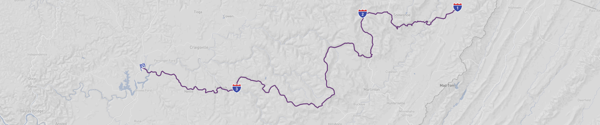
West Virginia Highland Panoramic Road Itinerary
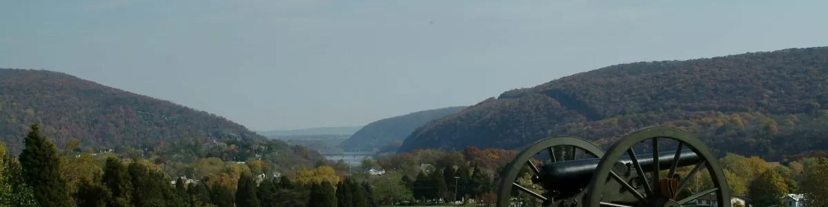
The West Virginia Highland Panoramic Road is an unforgettable journey through some of the most beautiful and unique landscapes in the US. Starting in Arbovale and ending in Summersville, this 162 km route is best experienced during the warmer months of the year. Along the way, you'll pass through towns like Slaty Fork and Richwood, and enjoy spectacular views of the Allegheny Mountains. The road is in excellent condition, and suitable for all drivers. You can complete the trip in a day, or take your time and explore the area. What's more, you can do it all on a moderate budget, making this road trip a great way to enjoy a memorable experience without breaking the bank.
 1
number of days
1
number of days
 162 km
route length
162 km
route length
 fair
budget
fair
budget
 family
good for
family
good for
 on the right
traffic direction
on the right
traffic direction
 low
accident level
low
accident level
START
Arbovale
Distance 162 km
Driving time 2.5 h
Pace: fast
48.7 kWh
Airports
IAD
[detailsContainer]
Arbovale is a unique destination situated in the Eastern Panhandle of West Virginia and is an ideal starting point for the West Virginia Highland Panoramic Road. Arbovale has a lot to offer, from breathtaking panoramic views to a variety of outdoor activities. The Highland Panoramic Road is a perfect way to experience all that Arbovale has to offer. Along the way, visitors can enjoy the majestic views of the Appalachian Mountains, the beautiful Greenbrier River, and the rolling hills of the Allegheny Plateau.
Arbovale is also home to many interesting locations to explore. Visitors can visit the historic Arbovale Lumber Mill, the Arbovale National Wildlife Refuge, and the Monongahela National Forest. Additionally, there are a variety of recreational activities available, such as hiking, fishing, and biking.
For those traveling by air, the closest international airport is the Greater Pittsburgh International Airport (PIT). Car rentals are available at the airport for those wishing to explore the area.
Arbovale is the perfect starting point for the West Virginia Highland Panoramic Road. With its stunning views, historic locations, and recreational activities, Arbovale is sure to provide a memorable adventure.
1
Arbovale
- Slaty Fork
Distance 38 km
Driving time 0.6 h
Pace: fast
11.5 kWh
↓
View map
↓
Itinerary
[detailsContainer]
Are you ready for an amazing road trip from Arbovale to Slaty Fork? This 24mi journey will take you less than an hour to complete and you will get to see some of the most interesting places in the area.
Start your journey in Arbovale and visit the beautiful Seneca State Forest. Here you can enjoy outdoor activities such as hiking, camping, and fishing. Then, make your way to the Greenbrier River, where you can take a dip or go for a leisurely stroll.
Once you reach Slaty Fork, you'll get to see the picturesque Monongahela National Forest. Here, you can explore the trails, go on a sightseeing tour, or have a picnic.
For more information regarding attractions, accommodation options, recommended restaurants, and campsites along the route, check out the Itinerary of this stage. Have a great trip!
 Slaty Fork - United States - North America - Scenic Drive - Wikipedia
❯
❮
2
Slaty Fork
- Richwood
Distance 87 km
Driving time 1.3 h
Pace: fast
26.0 kWh
↓
View map
↓
Itinerary
[detailsContainer]
Embark on a 54mi journey from Slaty Fork to Richwood, a drive that will take you less than two hours. This is one of the stages of a larger tour, so make sure to take your time to enjoy the sights and sounds of the area.
Start your journey in Slaty Fork, where you can visit the National Radio Astronomy Observatory, a research center dedicated to the study of radio astronomy. Afterward, make sure to check out the Cass Scenic Railroad State Park, a historic steam locomotive park.
As you make your way to Richwood, you will pass by the Monongahela National Forest and the Seneca Rocks Visitor Center. At the Visitor Center, you can learn about the geology of the area and explore the trails that lead to the top of the Seneca Rocks.
When you reach Richwood, you can visit the Richwood Historic District, a historic district listed on the National Register of Historic Places. Here, you can explore the historic buildings, visit the Richwood Museum, and take in the beauty of the town.
For more information regarding attractions, accommodation options, recommended restaurants, and campsites along the route, please refer to the "Itinerary" of this stage.
Richwood - United States - North America - Scenic Drive - Wikipédia
❯
❮
3
Richwood
- Summersville
Distance 37 km
Driving time 0.6 h
Pace: fast
11.2 kWh
↓
View map
↓
Itinerary
[detailsContainer]
Welcome, road-trippers! Get ready for an amazing journey from Richwood to Summersville, a distance of 23mi that can be covered in less than an hour.
The first stop is in Richwood, where you can explore the Richwood Railroad Museum, a unique place to learn about the area’s history, or take a stroll in the Richwood Botanic Garden and enjoy the beauty of nature.
The next stop is in Summersville, where you can visit the Carnifex Ferry Battlefield State Park, a great place to learn about the Civil War. There is also the Summersville Lake, a great spot for swimming, fishing, and kayaking.
For more information regarding attractions, accommodation options, recommended restaurants, and campsites along the route, check out the "Itinerary" of this stage.
Have a safe and enjoyable trip!
Summersville - United States - North America - Scenic Drive - Wikimedia Commons
❯
❮
Summersville
[detailsContainer]
Summersville, located in the United States, is the perfect end point to a stunning road trip known as the West Virginia Highland Panoramic Road. This route will take you through some of the most beautiful landscapes in the country, giving you the perfect opportunity to take in the sights of the Appalachian Mountains.
Once you reach Summersville, you can explore its many attractions. The Summersville Lake Retreat offers a range of activities, from fishing to swimming and boating. The town also has several parks and trails, offering the perfect spot for a picnic or a leisurely stroll. For those who enjoy art and culture, the Summersville Public Library is home to an impressive collection of books and artifacts.
If you're looking for a thrilling adventure, the New River Gorge National River is located nearby and offers a range of activities, including white water rafting, kayaking, and rock climbing. For those seeking an even greater adrenaline rush, the Fayetteville area hosts a range of outdoor activities, including zip lining, mountain biking, and ATV tours.
For those traveling by air, the closest international airport is the Yeager Airport (CRW) in Charleston, West Virginia. From there, you can rent a car and drive the rest of the way to Summersville.
Whether you're in the mood for a leisurely vacation or an exciting adventure, Summersville is the perfect end point of the West Virginia Highland Panoramic Road. With its stunning landscapes, rich culture, and thrilling activities, Summersville is sure to provide an unforgettable experience.
Summersville - United States - North America - Scenic Drive - Wikimedia Commons
❯
❮
West Virginia Highland Panoramic Road at a glance
-
Start:
Arbovale
-
End:
Summersville
-
Distance:
162 km
-
Stay:
1 day
-
Getting there:
Washington Dulles International Airport (IAD)
-
When to drive:
May, June, July, August, September
-
More info:
More info you can find in the "Itinerary" section at each stage.
Before you set off
Embark on a captivating journey along the West Virginia Highland Scenic Highway, a route that immerses Roadtrippers in the heart of the Appalachians. Extending for roughly 162 km (100 miles), this picturesque drive starts in Arbovale and winds its way to Summersville, showcasing the rugged beauty of the Allegheny Mountains. As you navigate this stretch of the Mountain State, prepare to be enchanted by verdant forests, sweeping vistas, and the unique charm of West Virginian towns.
Key Destinations and Top Sights:
- Arbovale: This quaint community marks the beginning of your adventure, offering a cozy atmosphere and a glimpse into West Virginia's rural life.
- Slaty Fork: Nestled amidst pristine nature, Slaty Fork is a haven for outdoor enthusiasts, with opportunities for hiking, fishing, and experiencing the serene beauty of the Appalachian wilderness.
- Richwood: Known as the `Ramp Capital of the World` for its annual festival celebrating the wild leek, Richwood is the perfect portal to the Monongahela National Forest, where travelers can encounter diverse wildlife and partake in a myriad of recreational activities.
- Summersville: Your journey culminates near the shores of Summersville Lake, a stunning body of water famed for its clear blue waters, offering an array of water sports, rock climbing, and the impressive Summersville Dam.
Best Time to Go:
Travelers will find the optimal conditions for this Road Trip from late spring to early fall when the weather is pleasant, and the full spectrum of the region's natural splendor is on display. The fall foliage period, in particular, offers a breathtaking palette of colors that beautifully enhance the already stunning vistas.
Potential Risks:
Traversing mountainous terrain can present challenges; sudden weather shifts and fog can affect visibility and Road conditions. It's essential to stay informed about local forecasts and be equipped for varying weather, especially during the colder months when snow can be a factor.
Interesting Facts for Roadtrippers:
- The journey along the Highland Scenic Highway is part of Route 150, a National Scenic Byway, recognized for its extraordinary landscapes.
- This Road is renowned for its high elevation, peaking at over 4,500 feet, which provides unparalleled views of the Appalachians.
- Along the drive, you'll find multiple scenic overlooks, such as the Honeycomb Rocks and the Falls of Hills Creek, that offer opportunities for photography and nature appreciation.
- The route passes near the Cranberry Glades Botanical Area, a subalpine wetland that houses rare plant species more commonly found in Canada.
A good choice for:
The West Virginia Highland Scenic Highway is more than a Road Trip; it's an invitation to connect with the wilderness, history, and culture of West Virginia. With its exceptional views, recreational offerings, and affordability, this journey is an unforgettable experience for nature lovers, adventure seekers, and those yearning to discover the less-traveled paths of America's scenic byways.
 -
-