Trans Canada Highway Road Trip Itinerary
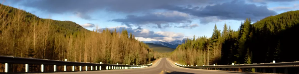
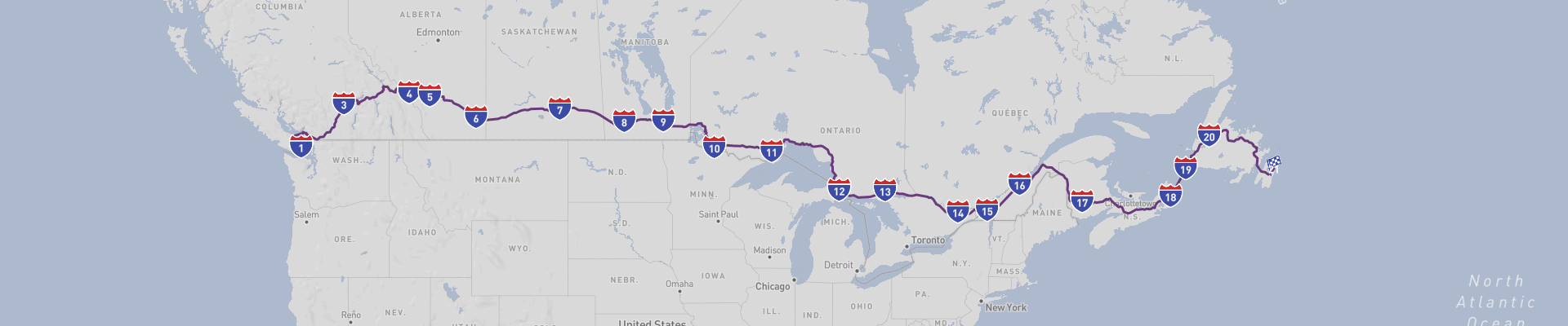
The Trans Canada Highway Road Trip is a spectacular journey across some of Canada's most beautiful landscapes. Starting in the city of Victoria and ending in St. John's, this 7395km route takes you through some of the country's most iconic towns, including Vancouver, Banff, Medicine Hat, Brandon, and Fort Frances. Along the way, you'll experience the stunning views of the Rocky Mountains, the prairies of Alberta and Saskatchewan, and the rugged beauty of the Atlantic coast. With a recommended time of 28 days to complete the journey, the best time of year to embark on this road trip is in the summer months.
Along the way, you'll have the opportunity to explore UNESCO Heritage Monuments and take in the unique culture of each town you visit. The roads are generally in excellent condition, but some sections may be curvy. No matter your driving experience, this road trip is suitable for everyone. With moderate budgeting, you can enjoy a very high level of experiences and memories. Don't miss out on this incredible journey - the Trans Canada Highway Road Trip awaits!
 28
number of days
28
number of days
 7,734 km
route length
7,734 km
route length
 fair
budget
fair
budget
 tourist
good for
tourist
good for
 on the right
traffic direction
on the right
traffic direction
 moderate
accident level
moderate
accident level
START
Victoria
Distance 7,734 km
Driving time 94.0 h
Pace: fast
2,320.2 kWh
Airports
YYJ
[detailsContainer]
Victoria, the capital of British Columbia, is a great starting point for the Trans Canada Highway Road Trip. This beautiful city, located on the southern tip of Vancouver Island, offers plenty of attractions and activities to explore. One of the most popular sights is the world-famous Butchart Gardens, which are full of vibrant and colorful flowers. For those who enjoy outdoor activities, there are plenty of trails and parks to explore, such as Beacon Hill Park, a popular destination for walking, running, and cycling.
To get to Victoria, travelers can fly into the Victoria International Airport (YYJ), which is located just north of the city. At the airport, travelers can rent a car for their road trip, making it easy to explore the city and its surrounding areas.
Victoria is also a great place to experience the unique culture and cuisine of British Columbia. The city has many restaurants and breweries, offering a wide variety of local dishes and drinks. Additionally, the area is home to numerous galleries, art studios, and theatres, making it a great spot for art and culture.
No matter your interests, Victoria is a wonderful place to start the Trans Canada Highway Road Trip. With its vibrant culture, beautiful scenery, and plenty of attractions, it is sure to be an unforgettable experience.
1
Victoria
- Vancouver
Distance 217 km
Driving time 4.4 h
Pace: modest
56.4 kWh
↓
View map
↓
Itinerary
[detailsContainer]
Embark on a 217 km road trip from Victoria to Vancouver and experience the beauty of British Columbia! Start your journey in Victoria, the capital of British Columbia, and explore the city's rich history and culture. From there, head to Nanaimo and enjoy the picturesque landscapes and scenic roads. Be sure to look out for historical sites and attractions along the way. Then, cross the Strait of Georgia via a ferry from Nanaimo to Horseshoe Bay. This ferry crossing will give you a unique view of the beautiful ocean waters and mountains. Finally, continue your journey from Horseshoe Bay to Vancouver, the largest city in BC. On the way, you will be treated to winding roads and stunning views of the surrounding mountains, forests, and lakes. Don’t forget to take some photos to remember this amazing journey! With fewer than 4 hours of driving time, you’ll be in Vancouver before you know it. For more information about attractions, accommodation options, recommended restaurants, and campsites along the route, be sure to check out the “Itinerary” of this stage. Enjoy your road trip!
 Vancouver - Canada - North America - Road Trip - Tourism Vancouver
Vancouver - Canada - North America - Road Trip - vancouver.ca
❯
❮
2
Vancouver
- Kamloops
Distance 349 km
Driving time 3.6 h
Pace: fast
104.6 kWh
↓
View map
↓
Itinerary
[detailsContainer]
If you are looking for an exciting road trip, then look no further than the journey from Vancouver to Kamloops. This 349 km journey will take you less than 4 hours and will take you through some of the most picturesque places in British Columbia.
The first stop is the picturesque town of Hope, located at the confluence of the Fraser and Coquihalla Rivers. Here you can take in the breathtaking views of the surrounding mountains and the rushing rivers. There are also several hiking trails for those looking for a more active experience.
Your next stop is the vibrant city of Kamloops. Here you can explore the many attractions, such as the Kamloops Art Gallery, the Kamloops Heritage Railway and the Kamloops Wildlife Park. Alternatively, you can take in the stunning views from the top of the nearby mountains or relax in one of the many parks and lakes.
This is just one of the stages of a larger tour, and for more information regarding attractions, accommodation options, recommended restaurants, and campsites along the route, please refer to the "Itinerary" of this stage. So, pack your bags and hit the open road for an unforgettable journey!
Kamloops - Canada - North America - Road Trip - www.wallpaperflare.com
❯
❮
3
Kamloops
- Banff
Distance 494 km
Driving time 5.8 h
Pace: fast
148.3 kWh
↓
View map
↓
Itinerary
[detailsContainer]
Are you ready for an amazing road trip from Kamloops to Banff? This journey will take you through some of the most beautiful landscapes and historical sites of Canada. Get ready to drive 495km and enjoy the scenery in fewer than 6 hours.
First, you will drive through the majestic Glacier National Park, where you can admire the breathtaking views of the Rocky Mountains. Don't forget to take some pictures of the amazing wildlife and nature.
The second stop of your journey is in Banff, a beautiful town surrounded by mountains, glaciers and alpine meadows. Here you can explore the natural wonders of the area, such as the Banff Gondola, the Cave and Basin National Historic Site, and the Banff Upper Hot Springs.
You will have plenty of time to explore the attractions and take pictures along the way. For more information about attractions, accommodation options, recommended restaurants and campsites along the route, you can refer to the itinerary of this stage.
So, what are you waiting for? Pack your bags and head out on this amazing road trip from Kamloops to Banff and enjoy the breathtaking views and the amazing historical sites along the way!
Banff - Canada - North America - Road Trip - Wikimedia Commons
❯
❮
4
Banff
- Calgary
Distance 125 km
Driving time 1.3 h
Pace: fast
37.6 kWh
↓
View map
↓
Itinerary
[detailsContainer]
Embark on an unforgettable road trip from Banff to Calgary! This 125 km journey is filled with breathtaking scenery and fascinating landmarks. Along the way, you'll pass through the Banff National Park, a UNESCO World Heritage Site, and enjoy picturesque views of the Rocky Mountains. From the majestic lakes to the lush forests, you'll find plenty to explore. As you drive, be sure to take in the historical sites and take some stunning photographs. Your journey will take less than two hours, so you'll have plenty of time to enjoy the sights. Once you arrive in Calgary, you'll find plenty of attractions to explore and activities to take part in. For more information on the attractions, accommodation options, restaurants, and campsites along the route, check out the Itinerary for this amazing stage of your road trip!
Calgary - Canada - North America - Road Trip - Needpix.com
Calgary - Canada - North America - Road Trip - Flickr
Calgary - Canada - North America - Road Trip - Wikipedia
❯
❮
5
Calgary
- Medicine Hat
Distance 294 km
Driving time 3.0 h
Pace: fast
88.1 kWh
↓
View map
↓
Itinerary
[detailsContainer]
Are you ready for an amazing road trip from Calgary to Medicine Hat? This stage of your journey will take you through the beautiful Alberta province, and you won't want to miss the incredible sights along the way.
Start your adventure in Calgary, where you can visit the Calgary Tower, the Calgary Zoo, and the Glenbow Museum. Then, take the scenic drive to Medicine Hat, a journey of 294km that can be completed in less than 3 hours. As you make your way, you'll pass through the small towns of Strathmore and Brooks, where you can take a break and explore the local attractions.
Once you arrive in Medicine Hat, you'll be greeted by the beautiful Saamis Teepee, which stands as a symbol of the city's vibrant culture. You can also visit the Medalta Potteries and the Medicine Hat Clay Industries National Historic Site. Don't forget to take a stroll along the South Saskatchewan River, where you can take in the stunning views of the city.
For more information about attractions, accommodation options, recommended restaurants, and campsites along the route, check out the "Itinerary" of this stage. Get ready to experience the beauty of Alberta on your Calgary to Medicine Hat road trip!
Medicine Hat - Canada - North America - Road Trip - Wikipedia
❯
❮
6
Medicine Hat
- Regina
Distance 463 km
Driving time 4.6 h
Pace: fast
138.9 kWh
↓
View map
↓
Itinerary
[detailsContainer]
Welcome to the Medicine Hat - Regina stage of your road trip! This 464 km drive will take you less than 5 hours, so get ready to explore some of the best sights of Alberta and Saskatchewan.
Start your journey in Medicine Hat, a city filled with history and culture. You can visit the Esplanade Arts & Heritage Centre, a museum and art gallery that showcases local history and art. You can also explore the Medicine Hat Clay Industries National Historic District, the largest of its kind in Canada.
As you drive, keep an eye out for the Cypress Hills Interprovincial Park, an area of stunning beauty that straddles Alberta and Saskatchewan. You can take a hike, go camping, or just take in the breathtaking view.
Finally, you'll arrive in Regina, the capital of Saskatchewan. Here, you can explore the Royal Saskatchewan Museum, which showcases the natural and cultural history of the province. You can also visit the Saskatchewan Legislative Building, the impressive seat of government for Saskatchewan.
Be sure to check out the "Itinerary" of this stage for more information on attractions, accommodation options, recommended restaurants, and campsites along the route. Enjoy your journey!
Regina - Canada - North America - Road Trip - www.needpix.com
❯
❮
7
Regina
- Brandon
Distance 368 km
Driving time 3.8 h
Pace: fast
110.4 kWh
↓
View map
↓
Itinerary
[detailsContainer]
Welcome, road-trippers! This stage of your journey will take you from Regina, Canada to Brandon, a 371km drive that should take fewer than 4 hours.
From Regina, start your journey by visiting the Wascana Centre, a beautiful 930-hectare park located in the heart of the city. Here you can explore the lake, gardens, and trails, and take in the breathtaking views.
Continue your trip to Fort Qu'Appelle, and explore the picturesque valley that was once home to the Cree, Saulteaux, and Nakota Sioux. Here you can visit the Fort Qu'Appelle Valley Museum, which houses artifacts and stories from the area's past, as well as a replica of the original fort.
Your next stop is the town of Virden. Here you can explore the charming downtown area, where you can find restaurants, shops, and galleries. You can also visit the T.rex Discovery Centre, where you can learn about the world's most famous dinosaur.
Your final destination is Brandon, where you can visit the Commonwealth Air Training Plan Museum, which tells the story of Canada's role in the Second World War. You can also explore the city's parks and trails, or take in a show at the Western Manitoba Centennial Auditorium.
For more information regarding attractions, accommodation options, recommended restaurants, and campsites along the route, please refer to the Itinerary of this stage. Enjoy your journey!
Brandon - Canada - North America - Road Trip - Wikimedia Commons
❯
❮
8
Brandon
- Winnipeg
Distance 219 km
Driving time 2.7 h
Pace: fast
65.8 kWh
↓
View map
↓
Itinerary
[detailsContainer]
Are you ready for the perfect road trip adventure? Then get your car ready for a 219 km drive from Brandon, Canada to Winnipeg! Along the way, you can visit some of the most interesting places in both cities. In Brandon, make sure to check out the Commonwealth Air Training Plan Museum, the Daly House Museum, and the Brandon Hills Nature Reserve. In Winnipeg, you can explore the Manitoba Museum, the Canadian Museum for Human Rights, and the Assiniboine Park Zoo. The entire drive will take you less than three hours, so you’ll have plenty of time to explore these amazing places. Plus, you can find more information about attractions, accommodation options, recommended restaurants, and campsites along the route in the “Itinerary” of this stage. So, what are you waiting for? Start your road trip adventure today!
Winnipeg - Canada - North America - Road Trip - Macleans.ca
❯
❮
9
Winnipeg
- Fort Frances
Distance 425 km
Driving time 4.8 h
Pace: fast
127.6 kWh
↓
View map
↓
Itinerary
[detailsContainer]
Embark on an exciting road trip from Winnipeg, Canada to Fort Frances, a journey of 425 km that will take you fewer than 5 hours. This is one of the stages of a larger tour, but you can enjoy it on its own as well.
Start your trip in Winnipeg, where you can visit the Manitoba Museum, the Manitoba Legislative Building, and the Assiniboine Park Zoo.
As you drive through the countryside, make sure you stop in Kenora, a city on the shores of Lake of the Woods. Here you can visit the Kenora Harbourfront, the Kenora and Lake of the Woods Regional Community Centre, and the Kenora Recreation Centre.
Continue your journey to Fort Frances, a small town on the banks of Rainy River. Here you can explore the Fort Frances Museum, the Fort Frances Canadian Bass Championship and the Fort Frances Sports Hall of Fame.
Make sure to check the "Itinerary" of this stage for more information regarding attractions, accommodation options, recommended restaurants, and campsites along the route. Enjoy your road trip!
Fort Frances - Canada - North America - Road Trip - Wikiwand
Fort Frances - Canada - North America - Road Trip - Wikipedia
❯
❮
10
Fort Frances
- Thunder Bay
Distance 350 km
Driving time 4.3 h
Pace: fast
104.9 kWh
↓
View map
↓
Itinerary
[detailsContainer]
Greetings, road-trippers! Are you ready for a unique experience? Then let's start off in Fort Frances, Canada, and head towards Thunder Bay, 350km away. This journey will take you less than 5 hours, and you will have plenty of time to explore the most interesting places along the way.
In Fort Frances, be sure to check out the Fort Frances Museum, where you can learn about the history of the area and its cultural heritage. If you're looking for something more adventurous, you can take a boat tour of Rainy Lake and explore the many islands in the area.
As you continue your journey, you'll see the breathtaking landscapes of Northwestern Ontario. Make sure to keep an eye out for historical sites, such as the Memorial Park in Atikokan, which honours the veterans of World War I and II.
Finally, you'll arrive in Thunder Bay, where you can take a tour of the Terry Fox Monument, a tribute to the legendary Canadian athlete. You can also explore the city's many parks and trails, as well as its vibrant cultural scene.
For more information about attractions, accommodation options, recommended restaurants, and campsites along the route, check out the Itinerary of this stage. Enjoy your adventure!
Thunder Bay - Canada - North America - Road Trip - www.thunderbay.ca
❯
❮
11
Thunder Bay
- Sault Ste. Marie
Distance 695 km
Driving time 7.8 h
Pace: fast
208.6 kWh
↓
View map
↓
Itinerary
[detailsContainer]
Embark on an amazing road trip from Thunder Bay to Sault Ste. Marie! This 695km drive will take you less than 8 hours to complete, so make sure to take advantage of the many attractions along the way.
Start your adventure in Thunder Bay and explore the city’s many historical sites, such as the Fort William Historical Park and the Prince of Wales Fort National Historic Site. Then, take a scenic drive to the Sleeping Giant Provincial Park, home to beautiful hiking trails and breathtaking views.
Continue your journey to Sault Ste. Marie, where you can explore the Agawa Rock Pictographs, the Sault Ste. Marie Canal National Historic Site, and the Ermatinger Clergue National Historic Site. The city also features a variety of shops, restaurants, and entertainment venues.
This is just a taste of what you can experience on this road trip. For more information on attractions, accommodation options, recommended restaurants, and campsites along the route, check the Itinerary of this stage. So, pack your bags and hit the road to discover the beauty of Thunder Bay and Sault Ste. Marie!
Sault Ste. Marie - Canada - North America - Road Trip - www.flickr.com
❯
❮
12
Sault Ste. Marie
- Sudbury
Distance 309 km
Driving time 3.6 h
Pace: fast
92.7 kWh
↓
View map
↓
Itinerary
[detailsContainer]
Welcome to one of the most beautiful road trips in Canada. Starting in Sault Ste. Marie, you will be travelling 309 km to Sudbury, in less than 4 hours. Along your way, you will discover some of the most interesting places in the region.
In Sault Ste. Marie, you can visit the Canadian Bushplane Heritage Centre, an aviation museum, or the Art Gallery of Algoma, to admire the works of local artists.
Further down the road, you will find the city of Elliot Lake, where you can explore the Centennial Tower, or take a stroll through the beautiful Centennial Park.
Continuing your journey, you will arrive in Blind River, home to the Blind River Community Museum, and the Blind River Beach Park, a great spot for swimming in the summer.
Finally, you will reach Sudbury, where you can visit Science North, a science museum, or the Big Nickel, a giant replica of a 1951 Canadian nickel.
Make sure to check the Itinerary of this stage for more information regarding attractions, accommodation options, recommended restaurants, and campsites along the route. Enjoy your trip!
Sudbury - Canada - North America - Road Trip - Wikimedia Commons
❯
❮
13
Sudbury
- Ottawa
Distance 484 km
Driving time 5.6 h
Pace: fast
145.2 kWh
↓
View map
↓
Itinerary
[detailsContainer]
Welcome to the exciting road trip from Sudbury to Ottawa! This journey of 485 km will take you less than 6 hours, so you can make the most of your time and explore the most interesting places along the way.
Start off your journey in Sudbury and take in the breathtaking views of the city's beautiful lakes and rivers. Then, make your way to the world-famous UNESCO World Heritage Site, the Rideau Canal. Take a stroll along the canal and marvel at the architectural beauty of the locks.
Continue your journey and explore the historic city of Kingston. Here, you can visit the Kingston City Hall and the Kingston Fortifications National Historic Site. Be sure to take a walk along the waterfront and admire the stunning views of Lake Ontario.
As you make your way to Ottawa, take a side trip to the charming town of Merrickville and explore the historic locks. Afterward, take a break in the town of Perth and enjoy the quaint shops and cafes.
Finally, arrive in Ottawa and explore the nation's capital. Visit the Parliament Buildings, the National Gallery of Canada, and the Royal Canadian Mint. Don't forget to take a stroll along the Rideau Canal and soak in the city's vibrant atmosphere.
For more information about attractions, accommodation options, recommended restaurants, and campsites along the route, please refer to the Itinerary of this stage. Enjoy your journey!
Ottawa - Canada - North America - Road Trip - Smart Cities World
❯
❮
14
Ottawa
- Montreal
Distance 198 km
Driving time 2.3 h
Pace: fast
59.4 kWh
↓
View map
↓
Itinerary
[detailsContainer]
Are you ready for an amazing road trip from Ottawa to Montreal? Get ready to explore the beauty of Canada! This 198km journey will take you less than 3 hours, and you'll get to see some of the most interesting sites in the country.
Your first stop should be the Rideau Canal in Ottawa. This UNESCO World Heritage Site is a 202km long canal connecting Ottawa to Kingston. It was built in the 19th century and is one of the oldest continuously operated canals in North America.
Continue your journey to Montreal and explore the unique culture of the city. Visit the Notre-Dame Basilica, a Gothic Revival church, and the Mont Royal Park, a beautiful green space in the city.
Make sure to check out the Biodome de Montreal, a unique indoor zoo and aquarium. You can also visit the Montreal Museum of Fine Arts and get a glimpse of the city's cultural heritage.
As you drive through the countryside, make sure to take in the beauty of the landscape. The rolling hills and lush forests will make for a memorable experience.
For more information about attractions, accommodation options, recommended restaurants, and campsites along the route, be sure to check out the "Itinerary" of this stage.
So what are you waiting for? Get ready to explore the beauty of Canada on this amazing road trip from Ottawa to Montreal!
Montreal - Canada - North America - Road Trip - Daily Hive
Montreal - Canada - North America - Road Trip
❯
❮
15
Montreal
- Quebec City
Distance 251 km
Driving time 2.9 h
Pace: fast
75.3 kWh
↓
View map
↓
Itinerary
[detailsContainer]
Embark on a road trip from Montreal to Quebec City and explore the best of both cities! This 252km journey takes less than 3 hours and is packed with some of the most interesting places to visit. From Montreal, head to the UNESCO World Heritage Site of Old Montreal, where you can explore the cobblestone streets and admire the city's unique architecture. Then, make your way to the breathtaking Montmorency Falls, one of the tallest waterfalls in the country. As you continue your journey, take in the picturesque landscapes of the Laurentian Mountains and the St. Lawrence River. Finally, arrive in Quebec City, where you can explore the UNESCO World Heritage Site of Old Quebec, the Citadelle of Quebec, and the Plains of Abraham. For more information on attractions, accommodation options, recommended restaurants, and campsites along the route, check out the Itinerary of this stage.
Quebec City - Canada - North America - Road Trip - Pixabay
Quebec City - Canada - North America - Road Trip - Wikipedia
Quebec City - Canada - North America - Road Trip - Wikipedia
❯
❮
16
Quebec City
- Fredericton
Distance 585 km
Driving time 5.8 h
Pace: fast
175.5 kWh
↓
View map
↓
Itinerary
[detailsContainer]
Welcome to the Quebec City-Fredericton road trip stage! This stage of your journey will take you through a picturesque 587km stretch of Eastern Canada, taking less than 6 hours of driving.
Your journey will start in Quebec City, the capital of the province of Quebec, where you can explore the cobblestone streets of the old city, and admire the impressive Chateau Frontenac. You can also visit the nearby Plains of Abraham, the site of the famous battle between the French and British armies.
On your way to Fredericton, you will pass through the charming villages of Rivière-du-Loup, Edmundston, and Grand Falls. Before arriving in Fredericton, be sure to stop in Woodstock and explore the historic buildings and churches.
Once in Fredericton, you can explore the city's many historic sites, including the Legislative Assembly of New Brunswick, the Beaverbrook Art Gallery, and the Christ Church Cathedral. You can also take a stroll along the St. John River, or take a boat tour of the city.
This stage of your tour is full of history and scenic views. For more information on attractions, accommodation options, recommended restaurants, and campsites along the route, be sure to check out the Itinerary of this stage. Enjoy your journey!
Fredericton - Canada - North America - Road Trip - PlanetWare
❯
❮
17
Fredericton
- North Sydney
Distance 652 km
Driving time 6.8 h
Pace: fast
195.6 kWh
↓
View map
↓
Itinerary
[detailsContainer]
Are you ready for an amazing road trip from Fredericton to North Sydney? This 653-km journey will take you less than 7 hours of driving, so you can fit in lots of sightseeing!
Start your trip in Fredericton, the capital of New Brunswick. Visit the Beaverbrook Art Gallery, the oldest public art gallery in Canada, and explore the vibrant downtown area.
You’ll then drive along the Bay of Fundy, renowned for its extreme tides. Stop at Hopewell Rocks, where you can explore the flowerpot rocks and the beach.
Continue your journey to Moncton and explore the historic downtown area. Visit the Magnetic Hill, an optical illusion where you can “drive” downhill with your car engine off!
Next, drive to Sydney, the largest city in Cape Breton Island. Enjoy the beautiful scenery and visit the Fortress of Louisbourg National Historic Site.
Finally, arrive in North Sydney and take a ferry to Newfoundland. Explore the waterfront and visit the nearby attractions.
For more information about attractions, accommodation options, recommended restaurants, and campsites along the route, please refer to the “Itinerary” of this stage. Enjoy your road trip!
North Sydney - Canada - North America - Road Trip - Wikimedia Commons
❯
❮
18
North Sydney
- Port Aux Basques
Distance 350 km
Driving time 11.7 h
Pace: slow
80.4 kWh
↓
View map
↓
Itinerary
[detailsContainer]
Welcome to the North Sydney-Port Aux Basques road trip stage, an exciting journey of 2km that takes less than 1 hour to complete! Starting from North Sydney, you will be able to visit the iconic Cabot Trail, a scenic drive that takes you to the top of the Atlantic Ocean. As you drive, you will be able to appreciate the stunning views of the surrounding landscapes. At the end of the journey, you will be welcomed by the ferry crossing that will take you to Port Aux Basques. Here, you will be able to explore the historic town of Port Aux Basques, visit the beautiful beaches, and take a stroll along the boardwalk.
For more information regarding attractions, accommodation options, recommended restaurants, and campsites along the route, please refer to the "Itinerary" of this stage. Enjoy your journey!
Port Aux Basques - Canada - North America - Road Trip - commons.wikimedia.org
❯
❮
19
Port Aux Basques
- Deer Lake
Distance 263 km
Driving time 2.7 h
Pace: fast
79.0 kWh
↓
View map
↓
Itinerary
[detailsContainer]
Welcome to the beautiful road trip stage from Port Aux Basques, Canada to Deer Lake! This 263 km drive will take you less than 3 hours, and you will be mesmerized by the picturesque landscapes you will see along the way.
Your journey begins in Port Aux Basques, a coastal town in Newfoundland and Labrador. Here, you can enjoy the beautiful beaches and visit the iconic lighthouse. You can also take a boat tour to the nearby islands and explore the unique marine life.
Your drive will continue to the town of Corner Brook, where you can take a break and visit the Corner Brook Museum and Archives. The museum is home to a variety of artifacts and exhibits, which tell the story of the city’s history and culture.
Afterwards, you will arrive in Deer Lake, where you can explore the breathtaking landscapes of Gros Morne National Park. Here, you can take a hike to the top of the Tablelands and enjoy the stunning views of the surrounding area.
Don’t forget to take some time to explore the town of Deer Lake itself. Here, you can visit the local shops and restaurants and take part in the many outdoor activities offered in the area.
For more information about attractions, accommodation options, recommended restaurants, and campsites along the route, please consult the “Itinerary” of this stage. Enjoy your road trip!
Deer Lake - Canada - North America - Road Trip - commons.wikimedia.org
❯
❮
20
Deer Lake
- St. John's
Distance 642 km
Driving time 6.5 h
Pace: fast
192.7 kWh
↓
View map
↓
Itinerary
[detailsContainer]
Start your road trip adventure in Deer Lake, Canada, and enjoy a scenic drive of 642 km to St. John's. Along the way, you will have the opportunity to explore some of the most beautiful landscapes in Canada and visit some of the most interesting places. You will be able to drive in less than 7 hours and enjoy the UNESCO Heritage sites that are along the route. This is one of the stages of a larger tour, but you can also enjoy it as a stand-alone trip. Make sure to keep your eyes open for the historical sites and picturesque landscapes that you'll pass by. You can also find more information regarding attractions, accommodation options, recommended restaurants, and campsites along the route in the "Itinerary" of this stage. So, what are you waiting for? Start planning your road trip adventure today!
St. John's - Canada - North America - Road Trip - Evening Standard
❯
❮
St. John's
[detailsContainer]
St. John's, the easternmost city in Canada, is the perfect ending point for your Trans Canada Highway Road Trip. Located on the Avalon Peninsula in the province of Newfoundland and Labrador, St. John's is a vibrant city with plenty to offer.
Take a stroll through the city's historic downtown, home to some of the oldest buildings in North America, and explore the many shops, restaurants and pubs. Take in the magnificent views of the harbor and Signal Hill, where the first transatlantic wireless signal was received in 1901.
For outdoor enthusiasts, hop on a boat and explore the harbor, or take a hike up Signal Hill and enjoy the stunning views of the area. If you're lucky, you might even spot a whale or two in the bay.
For a more cultural experience, visit The Rooms, the largest public cultural space in Newfoundland and Labrador. Here you can explore the permanent and temporary exhibits, as well as the provincial archives.
For those traveling by air, the closest international airport is St. John's International Airport (YYT).
No matter what you're looking for, St. John's is sure to have something that will make your Trans Canada Highway Road Trip unforgettable.
Trans Canada Highway Road Trip at a glance
-
Start:
Victoria
-
End:
St. John's
-
Distance:
7,734 km
-
Stay:
28 days
-
Getting there:
Victoria International Airport (YYJ)
-
When to drive:
May, June, July, August, September
-
More info:
More info you can find in the "Itinerary" section at each stage.
Before you set off
Embark on the quintessential Canadian odyssey along the Trans Canada Highway, stretching an impressive 7,821 kilometers (4,860 miles) from the Pacific shores of Victoria, British Columbia, to the historic city of St. John's, Newfoundland and Labrador. This vast transcontinental route offers adventurers a panoramic snapshot of Canada's rich tapestry of ecosystems, cultures, and landmarks. As the world's second-longest national highway, it presents an unparalleled opportunity to witness the sheer breadth of Canada's natural splendor and urban vibrancy.
Key Destinations and Top Sights:
This epic journey will take you through bustling metropolitan hubs and serene natural retreats alike. You'll experience Vancouver's urban coastal beauty, the cosmopolitan flair of Toronto, and the European charm of Quebec City. Revel in the awe-inspiring vistas of the Rocky Mountains in Banff National Park, and marvel at the rugged coastline of the Atlantic provinces. Along the way, explore national treasures such as the historic sites of Old Quebec, a UNESCO World Heritage Site, and witness the iconic prairies that are central to Canada's agricultural heritage.
Best Time to Go:
To make the most of this cross-country adventure, embark during the summer months, from late June to early September, when the days are long, the weather is pleasant, and the full array of tourist attractions and accommodations are available. This period also offers numerous festivals and outdoor activities that showcase Canada's cultural diversity and natural beauty.
Potential Risks:
While the highway is well-maintained, it traverses a variety of terrains, including mountain passes, rural plains, and coastal Roads that may present challenges such as sharp turns and steep inclines. Travelers should be prepared for sudden weather changes, especially in mountainous and coastal regions, and ensure their vehicles are well-equipped for long-distance travel.
Interesting Facts for Roadtrippers:
- The Trans Canada Highway was officially opened in 1962, though it was not fully completed until 1971.
- Taking this Road Trip is a thrilling way to experience all ten Canadian provinces.
- If you allocate about 28 days for this journey, you can immerse yourself in Canada's diverse environments and cultural scenes without rushing.
- A moderate budget can suffice for this Trip, with a variety of accommodations and dining options along the way to suit different preferences and financial plans.
A good choice for:
The Trans Canada Highway Road Trip is more than just a drive; it's a rite of passage that every Road Trip enthusiast should experience at least once. It offers a unique lens through which to discover the breadth of Canada's geographical splendor and the warmth of its people. From the Pacific to the Atlantic, this is your ticket to an unforgettable tapestry of memories and a testament to the spirit of exploration that defines the great Canadian landscape.
 -
-