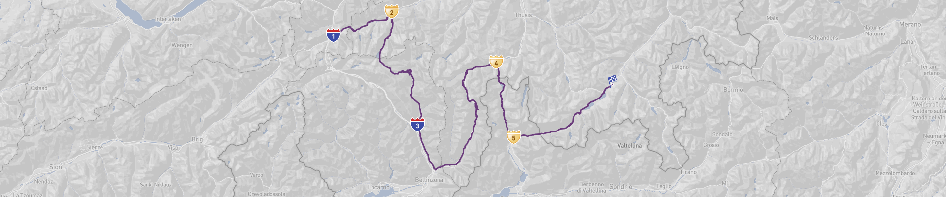
Through Swiss Curves Itinerary
Embark on an unforgettable journey through Swiss curves! This two-day road trip starts in the city of Andermatt, Switzerland and ends in St. Moritz. Along the route, you’ll traverse the stunning towns of Disentis Mustér, Splügen, and Chiavenna, with a total distance of 268km.
The best time to drive this road trip is during summer or early autumn, when the weather is mild and the roads are clear. You’ll be treated to some of the most picturesque views of Switzerland, from the alpine passes to the forested valleys. The roads are generally in excellent condition, although some may be curvy and narrow in places. Do keep in mind that there may be border crossings and seasonal road closures due to weather conditions.
This road trip is suitable for all drivers, and is sure to leave you with memories to last a lifetime. While it can be managed on a budget, it is definitely worth investing in for the highest level of experience.
 2
number of days
2
number of days
 268 km
route length
268 km
route length
 extreme
budget
extreme
budget
 tourist
good for
tourist
good for
 on the right
traffic direction
on the right
traffic direction
 moderate
accident level
moderate
accident level
START
Andermatt
Distance 268 km
Driving time 5.8 h
Pace: modest
69.7 kWh
Airports
ZRH
,
LUG
[detailsContainer]
Andermatt is the perfect starting point for the road trip "Through Swiss Curves". This small mountain village in the Swiss Alps provides a stunning backdrop to explore the surrounding area. Visitors to Andermatt will be greeted by the majestic Gotthard Pass, a winding mountain road that leads to the heart of Switzerland. The town is also home to the beautiful Furka Pass, where travelers can experience the breathtaking views of snow-capped mountains, lush valleys and picturesque Swiss villages.
The town of Andermatt offers plenty of attractions to explore. The Ursern Valley is a great place to explore on foot, with its unique landscape and stunning views. The nearby Oberalp Pass is a great place to go for a drive, and the views from the top are simply stunning. Additionally, the Andermatt Ski Resort is the perfect place to enjoy a day of skiing or snowboarding.
For visitors arriving by air, the closest international airport is Zurich Airport (ZRH). Car rentals are available at the airport for those wanting to explore the area by car.
No matter how you choose to explore Andermatt, visitors will surely be impressed by its picturesque views, unique attractions, and amazing alpine scenery. With its spectacular views and friendly locals, Andermatt is the perfect starting point for the road trip "Through Swiss Curves".
1
Andermatt
- Disentis Mustér
Distance 32 km
Driving time 0.7 h
Pace: modest
8.3 kWh
↓
View map
↓
Itinerary
[detailsContainer]
Embark on an unforgettable road trip from Andermatt to Disentis Mustér – a journey of 32km that will take you less than an hour to complete. As you drive, you’ll be treated to some of the most picturesque landscapes in Switzerland, with plenty of opportunities to take in the breathtaking views along the way. Be sure to keep an eye out for the steep ramps and winding roads, as they will add to the adventure of your journey. As you drive, you’ll come across some of the most beautiful villages in the country, so take your time to explore the area and enjoy all that it has to offer. Once you reach Disentis Mustér, you’ll find plenty of opportunities for accommodation, dining, and camping. For more information on attractions, accommodation options, recommended restaurants, and campsites along the route, please check the “Itinerary” of this stage.
 Disentis Mustér - Switzerland - Europe - Scenic Drive - commons.wikimedia.org
❯
❮
2
Disentis Mustér
- Biasca
Distance 61 km
Driving time 1.1 h
Pace: modest
15.9 kWh
↓
View map
↓
Itinerary
[detailsContainer]
Embark on a 61km road-trip through the stunningly beautiful Swiss mountain landscape, starting in Disentis Mustér, passing through Lucomagno Pass, and ending in Biasca. This journey should take you no longer than two hours and will be a memorable experience. As you drive, take in the stunning views of the Swiss Alps, rivers, and lakes. Pay special attention to the winding roads and narrow sections, as well as steep ramps, as some sections may be inaccessible to cars with camper trailers. In some sections, the road may be closed seasonally, so please take this into account. Along the way, be sure to take a break and explore the breathtaking views of the Swiss countryside. Visit the picturesque Valle Verzasca, located near the Lucomagno Pass, and enjoy the stunning views of the surrounding mountains. Be sure to take a stroll around the quaint village of Biasca, where you can find plenty of restaurants, accommodation options, and campsites. For more information about attractions, accommodation options, recommended restaurants, and campsites along the route, check out the "Itinerary" of this stage.
Biasca - Switzerland - Europe - Scenic Drive - commons.wikimedia.org
❯
❮
3
Biasca
- Splügen
Distance 88 km
Driving time 1.8 h
Pace: modest
22.8 kWh
↓
View map
↓
Itinerary
[detailsContainer]
Embark on an unforgettable road trip from Biasca, Switzerland to Splügen, 88km away! On the way, you'll traverse the San Bernardino Pass, a scenic road full of breathtaking views. With fewer than 2 hours of driving time, you'll be able to take in the majestic beauty of the Swiss Alps. Please be aware that some sections of the route may be closed seasonally, and some sections are inaccessible to cars with camper trailers. In addition, the road is very winding in some sections, and there are steep ramps and narrow parts. To make the most of your journey, keep your eyes peeled for the stunning views, and take advantage of any photo opportunities you come across. For more information regarding attractions, accommodation options, recommended restaurants, and campsites along the route, please refer to the "Itinerary" of this stage. Get ready for an unforgettable experience!
Splügen - Switzerland - Europe - Scenic Drive - www.wallpaperflare.com
❯
❮
4
Splügen
- Chiavenna
Distance 40 km
Driving time 1.1 h
Pace: slow
9.1 kWh
↓
View map
↓
Itinerary
[detailsContainer]
Starting in Splügen, Switzerland, this road trip takes you through some of the most beautiful places in the region. With a distance of 40 km, the trip takes less than 2 hours to complete. As you drive, you will cross the state border, and there will be sections of the route that are inaccessible to cars with camper trailers. Be aware that some sections may be closed seasonally and there will be steep ramps and very winding roads in some sections. In other sections, the road will be narrow. As you drive, you will be surrounded by breathtaking views and scenic roads, so make sure to take your time and enjoy the journey. Along the way, you will be able to visit Spluga Pass, one of the most beautiful places in the area. When you reach Chiavenna, your journey will be complete. For more information about attractions, accommodation options, recommended restaurants, and campsites along the route, please refer to the "Itinerary" of this stage.
Chiavenna - Switzerland - Europe - Scenic Drive - Wikipedia
Chiavenna - Switzerland - Europe - Scenic Drive - Wikipedia
❯
❮
5
Chiavenna
- St. Moritz
Distance 48 km
Driving time 1.0 h
Pace: modest
12.4 kWh
↓
View map
↓
Itinerary
[detailsContainer]
Embark on a scenic road trip from Chiavenna, Italy to St. Moritz, Switzerland! This 48 km long journey will take you less than 1 hour to complete, and you'll be crossing the state border along the way. Get ready to be mesmerized by the picturesque landscapes and the winding roads of Maloja Pass! Be aware that some sections of the route may be closed seasonally, and there are steep ramps in some parts of the road. Enjoy the breathtaking views of the snow-covered mountains, the lush green meadows, and the crystal lakes. Don't forget to take some amazing pictures of the valleys and the rivers that you'll pass by. For more information regarding attractions, accommodation options, recommended restaurants, and campsites along the route, please refer to the "Itinerary" of this stage.
St. Moritz - Switzerland - Europe - Scenic Drive - www.goodfreephotos.com
❯
❮
St. Moritz
[detailsContainer]
St. Moritz is the perfect ending point for the road trip "Through Swiss Curves". Located in the Engadin Valley in Switzerland, St. Moritz is a stunning mountain resort town, surrounded by the glistening Swiss Alps. The town is perfect for adventurers and sightseers alike, with plenty of activities to enjoy and plenty of beautiful sights to take in.
For those who love to explore the great outdoors, St. Moritz offers plenty of opportunities. The town is a great place for skiing and snowboarding, with a variety of slopes and trails to choose from. There are also plenty of other activities to enjoy, such as hiking, mountain biking, and paragliding. For those who prefer an easier pace, St. Moritz also offers plenty of shopping, restaurants, and cafes.
In addition to outdoor activities, St. Moritz is also home to plenty of attractions, including the Segantini Museum, the Engadin Art Museum, and the Alpina Museum. For those looking to take in some of the town’s history, the Church of San Gian is a must-see.
For those traveling by air, the closest international airport is located in Zurich (IATA code ZRH). From there, travelers can rent a car and drive to St. Moritz, taking in the stunning Swiss countryside along the way.
The road trip "Through Swiss Curves" ends in the beautiful mountain resort town of St. Moritz. With plenty of activities to enjoy and beautiful sights to take in, St. Moritz is the perfect place to end your journey.
Through Swiss Curves at a glance
-
Start:
Andermatt
-
End:
St. Moritz
-
Distance:
268 km
-
Stay:
2 days
-
Getting there:
Zürich Airport (ZRH),
Lugano Airport (LUG)
-
When to drive:
June, July, August, September
-
More info:
More info you can find in the "Itinerary" section at each stage.
Before you set off
Embark on a captivating two-day Road Trip from Andermatt to St. Moritz, traversing 268 kilometers of Switzerland's majestic alpine scenery. This journey treats travelers to a series of spectacular alpine passes, verdant valleys, and the enchanting vistas that make Switzerland a top destination for Road Trip enthusiasts.
Key Destinations and Top Sights:
- Andermatt: Kick off your adventure in this idyllic mountain village, nestled in the heart of the Swiss Alps, known for its ski slopes and hiking trails.
- Disentis Mustér: Explore this historic town featuring the Benedictine Disentis Abbey, founded in 720 AD, and a favorite for winter sports aficionados.
- Splügen: Immerse yourself in the charm of a picturesque Swiss village that's a gateway to the Splügen Pass, offering panoramic mountain views.
- Chiavenna: Discover this Italian gem just over the border, where you can marvel at the stunning Acquafraggia Waterfalls and explore rich medieval architecture.
- St. Moritz: Conclude your journey in this world-renowned resort town, synonymous with glamour, offering first-class winter sports, luxury shopping, and the pristine Lake St. Moritz.
Best Time to Go:
Summer and early autumn are the best seasons to enjoy this Road Trip, thanks to temperate weather and optimal driving conditions. During this time, the mountain passes are fully accessible, and the landscape is alive with vibrant colors.
Potential Risks:
- Mountainous terrain features curvy and narrow Roads that demand attentive driving skills.
- Seasonal Road closures, especially in winter, can affect travel plans.
- Border crossing into Italy requires awareness of customs regulations.
Interesting Facts for Roadtrippers:
- This route includes driving on the famous San Bernardino Pass and Julier Pass, each offering unique and breathtaking views.
- Andermatt is home to the impressive Devil's Bridge, part of the ancient Schöllenen Gorge, with legends dating back to the 13th century.
- St. Moritz has twice hosted the Winter Olympics and is often credited with being the birthplace of alpine winter tourism in the 1860s.
A good choice for:
This route is a mesmerizing blend of Switzerland's natural splendor with rich cultural experiences. It caters to a diverse array of interests, from historical exploration and outdoor activities to indulging in luxury and relaxation. Regardless of budget, this Road Trip through the Swiss Alps is a testament to the enduring allure of one of Europe's most beautiful regions.
 -
-