Cime de la Bonette Panoramic Road Itinerary
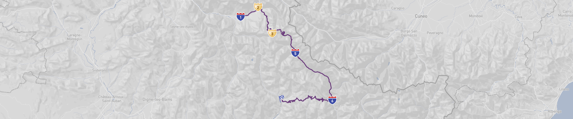
The Cime de la Bonette Panoramic Road is a 130km route through some of the most stunning landscapes in France. Starting in Barcelonnette and ending in Guillaumes, the route passes through Jausiers, Col de la Bonette, Cime de la Bonette, and Roure. You will experience a wide range of landscapes, from rolling hills to mountain peaks and dense forests.
The best time to drive this route is in the spring or summer months, when the weather is mild and the roads are in good condition. However, be aware that road closures due to weather conditions may occur. You may also encounter curvy and narrow roads along the way.
This is an unforgettable road trip that is suitable for all drivers and can be managed on a moderate budget. You can experience unique views and make lasting memories, while enjoying the beauty and tranquility of the French countryside.
 1
number of days
1
number of days
 130 km
route length
130 km
route length
 fair
budget
fair
budget
 tourist
good for
tourist
good for
 on the right
traffic direction
on the right
traffic direction
 moderate
accident level
moderate
accident level
START
Barcelonnette
Distance 130 km
Driving time 3.0 h
Pace: slow
30.0 kWh
Airports
NCE
[detailsContainer]
Barcelonnette is a charming French town located in the Alpes-de-Haute-Provence region, which is an ideal starting point to explore the majestic "Cime de la Bonette Panoramic Road". The town itself is known for its picturesque streets, its traditional architecture and its 18th century church.
Among the most interesting sights in town are the Château de Barcelonnette, the Place Chabaud and the Tour des Echevins. For those who want to take in the views of the surrounding mountains, the nearby Col de Vars is a great spot to visit. The area is also home to a wide variety of wildlife, including marmots, ibex and golden eagles.
For travelers arriving by air, the closest international airport is Nice Cote d'Azur Airport (IATA: NCE). The airport offers a wide range of car rental services for those who wish to explore the area by car.
Barcelonnette is a great place to start your road trip along the "Cime de la Bonette Panoramic Road". With its charming architecture, stunning mountain views and multitude of activities, the town is sure to provide an unforgettable experience for all who visit.
1
Barcelonnette
- Jausiers
Distance 9 km
Driving time 0.2 h
Pace: modest
2.4 kWh
↓
View map
↓
Itinerary
[detailsContainer]
Are you ready for an unforgettable road trip from Barcelonnette to Jausiers? This route is only 9 km long and takes less than 1 hour to drive, so you can easily squeeze it into your itinerary. Be aware that some sections of the road are quite narrow, but the stunning views of the Alps will make up for it. Make sure to take some pictures of the breathtaking landscapes and charming villages along the way.
You can make a stop in Barcelonnette to admire its picturesque architecture and explore the local culture. From there, you can drive to Jausiers, where you can visit the beautiful Notre-Dame de Bon-Secours Church and explore the surrounding nature.
For more information regarding attractions, accommodation options, recommended restaurants, and campsites along the route, please check the "Itinerary" of this stage. Enjoy your journey!
 Jausiers - France - Europe - Scenic Drive - commons.wikimedia.org
Jausiers - France - Europe - Scenic Drive - commons.wikimedia.org
❯
❮
2
Jausiers
- Col de la Bonette
Distance 22 km
Driving time 0.6 h
Pace: slow
5.1 kWh
↓
View map
↓
Itinerary
[detailsContainer]
Embark on an unforgettable road trip from Jausiers, France to Col de la Bonette, a 22 km drive that will take you less than an hour! As you make your way, marvel at the stunning scenic views of the French countryside. Be sure to take extra caution when driving, as some sections of the route may be closed seasonally, and the road has steep ramps, winding curves, and narrow sections. Along the way, you'll come across some of the most interesting places to visit, such as the picturesque Jausiers Valley, the beautiful alpine meadows of the Col de la Bonette, and the breathtaking views of the Mercantour National Park. Don't forget to take a break and explore the area, as there are plenty of activities to enjoy, from hiking and biking to fishing and horseback riding. For more information about attractions, accommodation options, recommended restaurants, and campsites along the route, please refer to the Itinerary of this stage. Enjoy the journey!
Col de la Bonette - France - Europe - Scenic Drive - es.m.wikipedia.org
❯
❮
3
Col de la Bonette
- Cime de la Bonette
Distance 1 km
Driving time 0.0 h
Pace: slow
0.2 kWh
↓
View map
↓
Itinerary
[detailsContainer]
Start your road trip adventure with a drive from Col de la Bonette in France to the Cime de la Bonette. This scenic route is just 1km long and can be driven in less than an hour. Along the way, you will encounter steep ramps, winding roads, and narrow sections of the road. Some sections may be closed seasonally, so be sure to check before you go. You'll be rewarded with stunning views of the countryside, so make sure to take your time and enjoy the journey! Don't forget to look out for the wildlife that may be around. When you reach Cime de la Bonette, you will be rewarded with a breathtaking view of the surrounding area. Make sure to take some time to take in the beauty of the landscape. For more information on attractions, accommodation options, recommended restaurants, and campsites along the route, be sure to check the "Itinerary" of this stage.
Cime de la Bonette - France - Europe - Scenic Drive - www.wallpaperflare.com
❯
❮
4
Cime de la Bonette
- Saint Etienne de Tinee
Distance 26 km
Driving time 0.6 h
Pace: modest
6.7 kWh
↓
View map
↓
Itinerary
[detailsContainer]
Embark on a unique road trip between Cime de la Bonette, France and Saint Etienne de Tinee! This 26km route is a great way to explore the stunning mountain views of the area, and will take you less than an hour to complete. As you drive along, be sure to keep an eye out for the scenic road, as well as some steep ramps and winding sections. The road can be narrow in some places, and some sections may be closed seasonally, so always pay attention and drive safely. Make sure to take advantage of the amazing views of the area and enjoy the journey! For more information on attractions, accommodation options, recommended restaurants, and campsites along the route, please refer to the "Itinerary" of this stage.
Saint Etienne de Tinee - France - Europe - Scenic Drive - commons.wikimedia.org
❯
❮
5
Saint Etienne de Tinee
- Roure
Distance 29 km
Driving time 0.5 h
Pace: modest
7.4 kWh
↓
View map
↓
Itinerary
[detailsContainer]
Are you looking for an exciting road trip? Starting in Saint Etienne de Tinee and ending in Roure, this 29 km journey is perfect for all types of adventurers. With a driving time of less than 1 hour, you'll have plenty of time to explore the best of both destinations.
On your way, you'll pass through winding roads, so take your time and make sure you're driving safely. You'll also find some narrow roads, so be mindful of other drivers and keep an eye out for cyclists.
Once you arrive in Saint Etienne de Tinee, be sure to check out the historical buildings and the beautiful gardens. You can also take a stroll along the River Tinee and take in the stunning views. In Roure, you can explore the local markets and sample some of the delicious cuisine.
For more information about attractions, accommodation options, recommended restaurants, and campsites along the route, be sure to check out the "Itinerary" of this stage. So, what are you waiting for? Start planning your road trip today!
Roure - France - Europe - Scenic Drive - commons.wikimedia.org
❯
❮
6
Roure
- Guillaumes
Distance 44 km
Driving time 1.1 h
Pace: slow
10.0 kWh
↓
View map
↓
Itinerary
[detailsContainer]
Are you ready for an amazing road trip from Roure to Guillaumes? This 44 km journey will take you less than an hour and you will be able to enjoy the beautiful scenery along the way. Be aware that the road is winding in some sections and narrow in others. You can find some of the most interesting places to visit in these locations, such as the Cave of Rouret, the Parc Naturel Régional du Verdon and the Tour de Guillaumes. Make sure to check out the Itinerary of this stage for more information about attractions, accommodation options, recommended restaurants and campsites along the route. So, what are you waiting for? Get ready and enjoy the ride!
Guillaumes - France - Europe - Scenic Drive - www.iha.com
❯
❮
Guillaumes
[detailsContainer]
Guillaumes is a small commune in the French Alps located at the end of the "Cime de la Bonette Panoramic Road". This road is considered one of the most scenic routes in Europe, winding through the mountains with stunning views. Guillaumes itself is a charming village with a relaxed atmosphere and plenty to explore.
The town is home to the Church of St. Jacques and the Museum of Les Merveilles, both of which are worth a visit. The Church of St. Jacques is a beautiful old church with a bell tower and is surrounded by a small park. The Museum of Les Merveilles is a great place to learn about the history and culture of the area.
Guillaumes is also known for its outdoor activities such as hiking, mountain biking, and skiing. There are several trails and ski areas located in and around the town.
For those traveling to Guillaumes by car, the closest international airport is Nice Côte d'Azur Airport (NCE). From there, it is a short drive up the Cime de la Bonette Panoramic Road to reach Guillaumes.
At the end of the Cime de la Bonette Panoramic Road lies the beautiful town of Guillaumes. Whether you want to explore the local culture, go for a hike, or just enjoy the scenery, Guillaumes is the perfect destination for your next road trip.
Cime de la Bonette Panoramic Road at a glance
-
Start:
Barcelonnette
-
End:
Guillaumes
-
Distance:
130 km
-
Stay:
1 day
-
Getting there:
Nice-Côte d'Azur Airport (NCE)
-
When to drive:
July, August, September
-
More info:
More info you can find in the "Itinerary" section at each stage.
Before you set off
The Cime de la Bonette Panoramic Road, encompassing a breathtaking 130km route through the majestic French Alps, offers travelers an unforgettable journey from Barcelonnette to Guillaumes. This picturesque drive is one of the most beautiful in France, showcasing the stunning diversity of alpine landscapes.
Key Destinations and Top Sights:
- Barcelonnette: The starting point featuring a blend of French and Mexican architectural influences, stemming from the historical migration of local residents who made fortunes in Mexico and returned.
- Jausiers: A delightful village known for its grand villas, providing a glimpse into local history and culture.
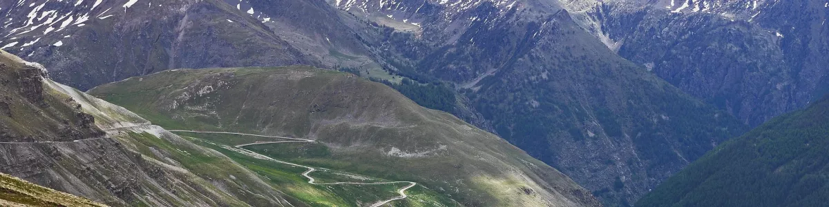
- Col de la Bonette: At an elevation of 2,715 meters, it's among the highest mountain passes in Europe, offering dramatic views and exhilarating driving experiences.
- Cime de la Bonette: At 2,802 meters, this vantage point surpasses the Col de la Bonette, offering a stunning 360-degree panorama of the French Alps. It's often mistaken as the highest Road in Europe, a title that actually belongs to Spain's Pico del Veleta.
- Roure: The endpoint of the route, this area offers enchanting vistas and a chance to observe traditional mountain life.
Best Time to Go:
The optimal season for this Road Trip is from June to September, when the pass is usually free of snow and the flora is in full bloom, creating a vibrant tapestry of colors across the alpine landscape.
Potential Risks:
- Sudden meteorological changes can prompt unexpected Road closures, especially during the shoulder seasons.
- The Road features several hairpin turns and narrow stretches that require careful navigation and a steady hand.
Interesting Facts for Roadtrippers:
- Cime de la Bonette is surrounded by the Mercantour National Park, home to a diverse range of wildlife including marmots, wolves, and golden eagles.
- The route is dotted with remnants of military fortifications, part of the Alpine Line (also known as the Little Maginot Line) built for the defense of France.
- The Road Trip is achievable on a modest budget, with various accommodation and dining options catering to different preferences.
- The panoramic Road is a paradise for cyclists as well, who challenge themselves on the steep climbs and enjoy the thrilling descents.
A good choice for:
A Road Trip along the Cime de la Bonette Panoramic Road is a captivating adventure that combines the thrill of alpine driving with the serenity of nature's grandeur. It's a journey that not only captures the essence of the French Alps but also offers a deep connection with the region's history and culture.
 -
-