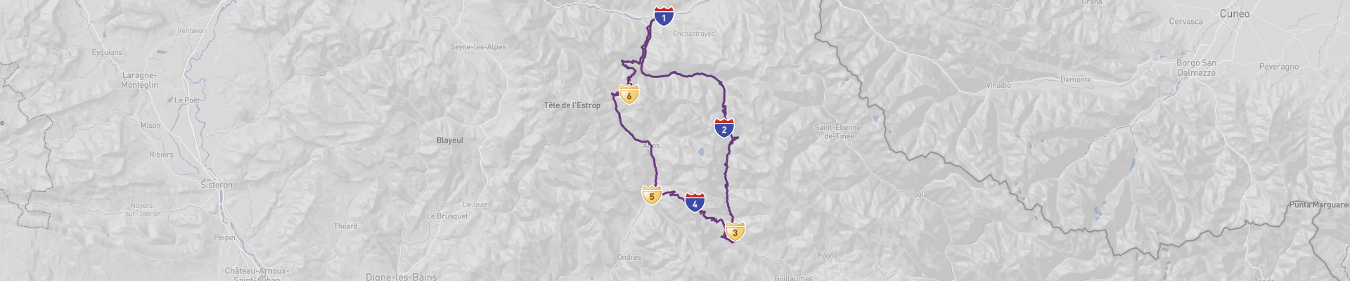
Col D'Allos & Col de Champs Panoramic Road Itinerary
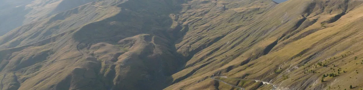
Experience breathtaking views and stunning scenery with the Col D'Allos & Col de Champs Panoramic Road! This 119 km route takes you through some of France's most breathtaking landscapes. The road trip starts in Barcelonnette and takes you through Col de la Cayolle, Saint Martin d'Entraunes, Col des Champs, Colmars les Alpes, and Col d'Allos before returning to Barcelonnette. It can be completed in one day, although taking your time to enjoy the views is highly recommended. The best time of the year to drive is in the summer months, when the weather is most conducive to sightseeing. Do be aware that the road conditions can be poor, and there may be seasonal road closures due to weather conditions. The route is partly curvy and partly narrow, so extra caution is advised. Despite this, the experience is sure to provide you with a very high level of experience and memories, and is suitable for every driver, regardless of budget.
 1
number of days
1
number of days
 119 km
route length
119 km
route length
 fair
budget
fair
budget
 tourist
good for
tourist
good for
 on the right
traffic direction
on the right
traffic direction
 fair
accident level
fair
accident level
START
Barcelonnette
Distance 119 km
Driving time 3.1 h
Pace: slow
27.3 kWh
Airports
NCE
[detailsContainer]
Barcelonnette is a charming French town nestled in the foothills of the Alps and the gateway to the spectacular "Col D'Allos & Col de Champs Panoramic Road", one of the most beautiful road trips in France. Located in the stunning region of Provence-Alpes-Côte d'Azur, Barcelonnette is the perfect starting point for this journey.
The town has plenty to offer, from its beautiful historic squares, to its picturesque churches, to the lively market that takes place every Thursday. Visitors should also take the time to explore the many local museums, galleries, and shops, as well as enjoy the local cuisine.
Those coming from abroad will find the closest international airport to Barcelonnette is Nice Côte d'Azur Airport (NCE), located around 165 km away. Car rentals are available at the airport, making it easy to access the town and begin your road trip.
Once you've arrived in Barcelonnette, you'll be ready to take on the "Col D'Allos & Col de Champs Panoramic Road", a route that will take you through some of the most stunning mountain scenery in France. Along the way, you'll find plenty of stops to take in the views, enjoy a picnic, and even explore some of the nearby villages.
Barcelonnette is truly a destination not to be missed. Whether you are looking to explore the town itself or take on the "Col D'Allos & Col de Champs Panoramic Road", you won't be disappointed with the beauty and culture this region has to offer.
1
Barcelonnette
- Col de la Cayolle
Distance 29 km
Driving time 0.7 h
Pace: modest
7.6 kWh
↓
View map
↓
Itinerary
[detailsContainer]
Embark on an unforgettable road trip from Barcelonnette to Col de la Cayolle! This 29km drive takes less than an hour, and you'll be surrounded by spectacular mountain scenery the whole way. Along the way, you'll be treated to breathtaking views of the snow-capped Alps, and the winding road will take you through stunning forests and past picturesque villages. Be sure to keep an eye out for the steep ramps, narrow roads, and winding sections along the way. Some sections may be closed seasonally, so be sure to check the conditions before you set out. This route is just one stage of a larger tour, and more information about attractions, accommodation options, recommended restaurants, and campsites along the route can be found in the "Itinerary" of this stage. So get ready for an unforgettable journey through the French Alps!
 Col de la Cayolle - France - Europe - Scenic Drive - pxhere.com
❯
❮
2
Col de la Cayolle
- Saint Martin d'Entraunes
Distance 20 km
Driving time 0.5 h
Pace: modest
5.3 kWh
↓
View map
↓
Itinerary
[detailsContainer]
Start your exciting road trip in Col de la Cayolle, France, and take a 20km drive to Saint Martin d'Entraunes. This route will take you less than an hour, and you'll be surrounded by breathtaking views along the way. Be aware that some sections of the road may be closed seasonally, so make sure to check before you go. There are steep ramps and winding roads, so make sure to stay alert and drive carefully. In some sections, the road is quite narrow, so be sure to give way to other drivers. Enjoy the scenic views and make sure to take lots of pictures! Once you reach Saint Martin d'Entraunes, you'll be able to explore the charming town and its surrounding area. For more information on attractions, accommodation options, recommended restaurants, and campsites along the route, check out the Itinerary of this stage.
Saint Martin d'Entraunes - France - Europe - Scenic Drive - commons.wikimedia.org
Saint Martin d'Entraunes - France - Europe - Scenic Drive - www.iha.com
❯
❮
3
Saint Martin d'Entraunes
- Col des Champs
Distance 16 km
Driving time 0.4 h
Pace: slow
3.7 kWh
↓
View map
↓
Itinerary
[detailsContainer]
Embark on a road trip from Saint Martin d'Entraunes to Col des Champs, a journey of only 16 km that will take you less than an hour to complete. As you drive along the winding road, take in the scenic views and pay attention to the steep ramps and narrow sections. You may also find some sections closed seasonally. Make sure to keep your eyes open for interesting sights! Along the way, you can visit the ruins of the Château de Montauban and the nearby waterfall. Further ahead, you can explore the ruins of the 12th century Château de la Garde. Finally, you’ll arrive at Col des Champs, where you can admire the stunning vistas. For more information about attractions, accommodation, restaurants, and campsites, be sure to check the “Itinerary” of this stage.
Col des Champs - France - Europe - Scenic Drive - commons.wikimedia.org
❯
❮
4
Col des Champs
- Colmars les Alpes
Distance 12 km
Driving time 0.3 h
Pace: slow
2.7 kWh
↓
View map
↓
Itinerary
[detailsContainer]
Embark on a 12 km road trip from Col des Champs, France to Colmars les Alpes and experience the beauty of the French countryside! This journey will take you less than an hour, and you’ll be able to take in the stunning views of the surrounding countryside. As you drive, keep an eye out for the steep ramps and winding roads, as some sections may be closed seasonally. You’ll also need to be aware of the narrow roads, so drive carefully and enjoy the scenery! Don’t forget to make a stop in Col des Champs and Colmars les Alpes to explore the local attractions and enjoy some delicious food. For more information on attractions, accommodation options, recommended restaurants, and campsites along the route, be sure to check the “Itinerary” of this stage. Enjoy your road trip!
Colmars les Alpes - France - Europe - Scenic Drive - commons.wikimedia.org
❯
❮
5
Colmars les Alpes
- Col d'Allos
Distance 22 km
Driving time 0.5 h
Pace: slow
5.0 kWh
↓
View map
↓
Itinerary
[detailsContainer]
Embark on a thrilling road trip from Colmars les Alpes to Col d'Allos, a 22 km journey that will take you less than an hour. Enjoy the scenic views of the stunning French countryside as you drive through winding roads, steep ramps and narrow sections. Take a break and enjoy the fresh air and peaceful atmosphere at the Col d'Allos, where you can admire the stunning views of the nearby mountains. Along the way, don't forget to check out the picturesque villages of La Mure and Le Lauzet-Ubaye. Keep in mind that some sections of the route may be closed seasonally, so make sure to check the itinerary of this stage before you go. For more information regarding attractions, accommodation options, recommended restaurants, and campsites along the route, make sure to check the "Itinerary" of this stage. So, what are you waiting for? Get ready to explore the beauty of the French countryside on your road trip from Colmars les Alpes to Col d'Allos!
Col d'Allos - France - Europe - Scenic Drive - www.iha.co.nz
❯
❮
6
Col d'Allos
- Barcelonnette
Distance 20 km
Driving time 0.7 h
Pace: slow
4.5 kWh
↓
View map
↓
Itinerary
[detailsContainer]
Embark on a road trip from Col d'Allos, France to Barcelonnette and take in the stunning views of the Southern Alps. This 20km journey will take you fewer than 1 hour, and you'll be able to take in the breathtaking scenery along the way. Although some sections of the route may be closed seasonally, you'll be able to take in the beauty of the area. Be aware of steep ramps and winding roads, as well as some sections of the road that may be narrow. Enjoy the scenic road as you make your way to Barcelonnette. For more information on attractions, accommodation options, recommended restaurants, and campsites along the route, please check the "Itinerary" of this stage.
Barcelonnette - France - Europe - Scenic Drive - Wikimedia Commons
❯
❮
Barcelonnette
[detailsContainer]
Barcelonnette is a charming French town located at the end of the magnificent "Col D'Allos & Col de Champs Panoramic Road". A drive through this spectacular route, with its winding roads and breathtaking views, is an unforgettable experience.
Barcelonnette is a great place to spend some time. Its winding streets and unique architecture make it a delightful place to explore. The main square, Place de la Republique, is a great spot to take in the atmosphere and watch the world go by. There are also plenty of bars, restaurants and shops to explore.
The area around Barcelonnette is also full of natural beauty. The nearby Ubaye Valley is perfect for hiking, and the scenic Lac de Serre-Poncon is a great place to relax.
For those arriving by air, the closest international airport is Nice-Cote d'Azur Airport (NCE). From there, it's a scenic drive of about 2 hours 15 minutes to Barcelonnette.
No matter how you get there, Barcelonnette is a great place to end your road trip along the "Col D'Allos & Col de Champs Panoramic Road". With its winding streets, unique architecture and stunning natural scenery, it's sure to be an unforgettable experience.
Barcelonnette - France - Europe - Scenic Drive - commons.wikimedia.org
❯
❮
Col D'Allos & Col de Champs Panoramic Road at a glance
-
Start:
Barcelonnette
-
End:
Barcelonnette
-
Distance:
119 km
-
Stay:
1 day
-
Getting there:
Nice-Côte d'Azur Airport (NCE)
-
When to drive:
July, August, September, October
-
More info:
More info you can find in the "Itinerary" section at each stage.
Before you set off
Embark on a mesmerizing 119 km journey along the Col D'Allos & Col de Champs Panoramic Road, nestled in the heart of France's stunning southern Alps, which starts and ends in the quaint town of Barcelonnette. This scenic route, renowned for its breathtaking vistas, is more than just a drive; it's an invitation to explore the rich natural tapestry of the region. While it can be completed in a single day, taking your time allows for a deeper connection with the landscape and its cultural heritage.
Key Destinations and Top Sights:
Traverse the majestic mountain passes of Col de la Cayolle, Col des Champs, and Col d'Allos, each offering unique panoramic views and a chance to marvel at the engineering feat of these winding Roads. En route, discover the charming village of Saint Martin d'Entraunes, with its traditional architecture, and the fortified town of Colmars les Alpes, steeped in history. Not to be missed are the serene Alpine lakes and the endemic flora and fauna, which provide a colorful tapestry against the mountain backdrop.
Best Time to Go:
The prime time for this alpine adventure is the summer months, typically from June to September, when the high-altitude passes are free from snow and the weather is conducive to outdoor activities such as hiking and picnicking amidst the captivating scenery.
Potential Risks:
Mountain Roads are notorious for their hairpin bends and unexpected conditions. Vigilance is required for narrow sections, potential rockfalls, and sudden weather changes, which can include fog and thunderstorms. Seasonal closures, usually from November to May due to snow, should be checked before setting out.
Facts for Roadtrippers:
This Road Trip is a haven for enthusiasts of all skill levels and budgets, offering diverse experiences from leisurely drives to adventurous explorations. It's wise to verify the latest Road conditions, ensure your vehicle is well-maintained, and bring along provisions for comfort and safety, including water, snacks, and warm clothing. Planning strategic stops at lookout points will maximize the visual rewards of this alpine passage.
Interesting Facts:
- The Col d'Allos is one of the highest mountain passes in Europe that is regularly included in the Tour de France cycling race.
- The route is part of the Mercantour National Park, one of France's ten national parks, known for its rich biodiversity including marmots, wolves, and golden eagles.
- Barcelonnette, the starting and ending point of the journey, is influenced by Mexican architecture, a unique legacy from locals who migrated to Mexico in the 19th century and returned to build lavish villas that still stand today.
- Colmars les Alpes is not only picturesque but also historically significant; it was once a strategic military site for defending against invasions during the reign of Louis XIV.
A good choice for:
For those who seek the thrill of the open Road and the serenity of high-altitude landscapes, the Col D'Allos & Col de Champs Panoramic Road is an exceptional journey. It's a treasure trove of natural splendor, offering glimpses into the soul of France's Alpine region and the promise of a truly memorable Road Trip experience.
 -
-